Safety summary
What happened
On 26 and 27 December 2015, the rail traffic crew of trains 9E56 and 9T92 encountered wet weather as they travelled toward Julia Creek. The Bureau of Meteorology had issued a series of localised severe thunderstorm warnings for the North West forecast district, which was normal during the wet season. The Network Control Officer (NCO) at the Queensland train control centre in Townsville was monitoring information on the BoM website and had received some information from the rail traffic crews who were travelling along the section. The NCO acted on the information available by arranging track inspections of the relevant sections of track west of Julia Creek.
As these inspections were occurring, train 9T92 continued travel toward Julia Creek from the east. Shortly after passing through a section of track where floodwaters had previously overtopped the track and receded, the crew of train 9T92 encountered another area where floodwater had overtopped the track. At this location, however, the floodwater had scoured the ballast and compromised the integrity of the track.
The driver became aware of the washout only moments before the locomotive impacted and derailed, causing the locomotive to tip on its side. After sighting the washout, the train crew could do nothing to prevent, or lessen the impact of the incident.
What the ATSB found
Scouring of the ballast and formation adjacent to the 617.190 km point by floodwater meant that the track could not support the weight of train 9T92 as it passed over the affected area. The resulting deformation in alignment of the track initiated the derailment. Reporting procedures implemented by Queensland Rail and Aurizon provided insufficient guidance to the NCO or rail traffic crew to identify and respond to potential hazards from a wet weather event.
What's been done as a result
Queensland Rail has issued Safety Alerts to improve the effectiveness of the current network rules in relation to managing hazards associated with weather events. A review of weather monitoring services and the upskilling knowledge of relevant personnel on interpreting meteorological information has also commenced. Queensland Rail has commenced a review into the feasibility of adopting the Australian Standard AS7637 Railway Infrastructure – Hydrology and Hydraulics.
Aurizon has introduced respiratory protection masks for train crew on trains transporting acid. Additionally Aurizon continues to reassess the emergency evacuation procedures, locomotive windscreens and secondary communication opportunities/options.
Safety message
Rail infrastructure managers must implement adequate operational procedures and training programs to ensure the timely identification and management of a hazard to the integrity of their rail infrastructure, such as a weather event. Rolling stock operators must ensure that their training programs include relevant operational procedures enabling consistent assessment, reporting and response by train crew to conditions that may adversely affect the integrity of rail infrastructure or trains.
Events prior to the derailment
In late December 2015, a tropical low embedded on an active monsoon trough extended across the tropical north of Australia. This weather system brought heavy rainfall to northern Australia and caused moderate rainfall in the northwest, northern, and southern areas of Queensland.
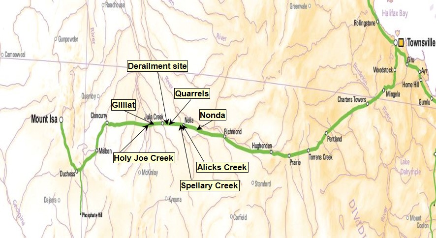
At about 0245[1] on 27 December 2015, the Queensland Rail (QR) Network Control Officer (NCO) for the Townsville far-west train control board received an intermittent alarm from the Rail Management System. The alarm indicated a high water level at Holy Joe Creek, located at the 681 km point, west of Julia Creek (Figure 1) on the Great Northern Railway (Mount Isa line).
About the same time, the crew of Aurizon train 9E56, travelling toward Julia Creek from the east, contacted the NCO to report encountering heavy rainfall around Nonda, located at the 561.340 km point, east of Julia Creek. The NCO recorded details of the alarm and the report from 9E56 on the train control graph.[2]
Figure 1: Locations, Mount Isa railway, Queensland

Railway connecting Townsville and Mount Isa, including the branch line toward Phosphate Hill. Train 9E56 was travelling west and was about 4.5 hours ahead of train 9T92. Train 9T92 was travelling from Townsville to Phosphate Hill but derailed about 20 km east of Julia Creek. Source: Geoscience Australia ©. Annotated by ATSB
Also at about 0245, the Aurizon crew involved in the derailment commenced their shift at Hughenden. The crew was to operate Aurizon train 9T92 (loaded with sulphuric acid) from Hughenden through Julia Creek to Cloncurry. Following the arrival of 9T92 from Townsville, the crew took control and after receiving authority from the NCO, departed for Cloncurry at about 0330 that morning. Train 9T92 was following about 5 hours behind the preceding train 9E56.
At about 0400, a shift change of the NCO for the Townsville far-west train control board occurred. The incoming and outgoing NCO’s performed a handover to provide a brief on the status of relevant train running information for that control area.
At about 0520, the crew of 9E56 reported more heavy rain on their arrival at Gilliat, located at the 664.260 km point, west of Julia Creek. Train 9E56 remained stopped at Gilliat to enable a QR track inspector to access the track at Cloncurry and travel to Gilliat. The track inspector’s task was to examine the track for flood damage through to Gilliat, and to investigate the high water alarm at Holy Joe Creek before train 9E56 traversed the area.
The track inspector left Cloncurry at about 0645, travelling towards Julia Creek from the west.
At the same, train 9T92 continued towards Julia Creek from the east. The latest report of heavy rainfall in the area east of Julia Creek was about 4 hours earlier, by the crew of 9E56 (now situated at Gilliat).
At about 0839, the crew of 9T92 reported to the NCO that they were approaching Nelia, located about 49 km east of Julia Creek. They reported there was ‘plenty of water everywhere’, and that they experienced periods of rainfall during their journey between Hughenden and Nelia – a distance of 212 km. The NCO advised that the previous train 9E56 had reported similar conditions.
A little later, as train 9T92 passed over Alick Creek (located about 42 km east of Julia Creek) the crew noted that there was a substantial water flow along that waterway. The train crew and QR knew this area to be a flooding ‘hot spot’.
At about 0900, as train 9T92 approached Spellary Creek (about 32 km east of Julia Creek), the crew observed floodwaters pooling adjacent to the track formation ahead. The driver slowed the train, stopping about 815 m before Spellary Creek. The train crew noted light debris over the track, indicating that floodwater had overtopped the track formation at some time, before receding.
Meanwhile, the track inspector travelling towards Julia Creek from the west had made several reports to the NCO enroute to Gilliat, noting the presence of floodwaters at the locations that had triggered the alarm. The alarm at Holy Joe Creek was false. The false alarm resulted from low battery voltage due to cloud cover causing insufficient solar charging. At about 0905, the track inspector completed the inspection to Gilliat and advised the NCO that the inspected track was fit for service and that train 9E56 could depart.
After crossing train 9E56 at Gilliat, the inspector requested an authority to continue the inspection toward Julia Creek. The NCO gave authority to continue to Julia Creek and advised the track inspector that a cross was to occur with 9T92, at Julia Creek.
The derailment
While train 9T92 was stationary at Spellary Creek, the train crew took the opportunity to change drivers. Following the crew’s assessment of the conditions ahead, the driver proceeded at a low speed through the affected area. The train crew had no immediate concern in proceeding as they could see the track and ballast. The water adjacent the track was not flowing and appeared to be receding.
After traversing the affected area, train 9T92 continued travelling west. At about 0920, the train crew contacted the NCO to report ‘water just lapping the ballast’ at Spellary Creek between the 605 and 607 km points. They also reported their observation related to light debris over the track, and that the floodwaters appeared to be receding.
In response to the floodwater report from the crew of 9T92, the NCO commenced arrangements for a second track inspection, this time starting from Richmond (behind 9T92) and travelling west toward Julia Creek. The QR Transit Manager at Townsville had also commenced arrangements to notify rail operators of the potential for service disruptions, due to closing the track west of Richmond for the inspection.
At about 0926, the crew of 9T92 again contacted the NCO and reported they were approaching Quarrels. The NCO acknowledged the communication and gave authority through Quarrels. After passing through Quarrels, the driver reduced speed to around 15 km/h to traverse a short section of track with a 15 km/h speed restriction (615 to 615.3 km).
The track between Quarrels and Julia Creek was not an identified flooding hot spot. Consequently, after clearing the 15 km/h speed restriction, the driver started to increase the speed of 9T92 toward the posted maximum track speed of 60 km/h west of the Quarrels loop.
At about 0933, with 9T92 travelling at about 51 km/h, one of the train crew saw an area of disturbed ballast between the rails that indicated a washout[3] about 45 m ahead and called out a warning to the rest of the crew. The driver recalled immediately moving the throttle to idle and the brake handle toward the emergency position. Shortly after, the locomotive entered the washout. The crew felt the locomotive bounce and saw water splash on the windscreen before it derailed and began to tip over. As the locomotive tipped, the diesel engine shut down automatically.
The pitching of the locomotive while traversing the washout and tipping ejected the train crew from their seats. All crewmembers sustained minor injuries (cuts and abrasions) from contact with structures within the locomotive cab.
Events post-derailment
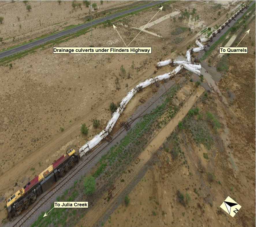
Train 9T92 had travelled about 2.6 km west of Quarrels before encountering the washout. The locomotive came to rest on its side to the north of the track, about 68 m past the washout (Figure 2). The locomotive was lying in about 600 mm of pooled floodwater. All of the 26 trailing tanker wagons had also derailed to the north of the track and were also lying in the pooled floodwaters.
Figure 2: Derailed train 9T92

The derailed locomotive 2814 and 26 trailing tanker wagons of 9T92 laying to the north of the railway about 20 km east of Julia Creek. The floodwaters present at the time of derailment had receded, however pooled water is still visible in the drainage channels from culverts under the Flinders Highway leading toward the washout of the track formation. Source: Queensland Police Service
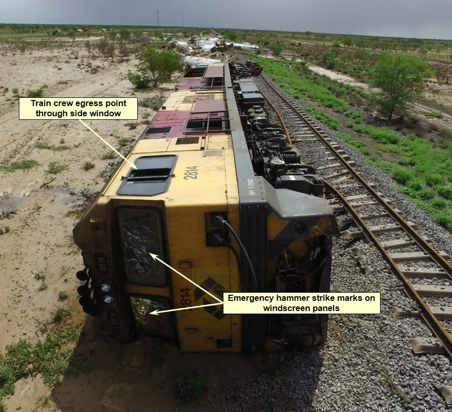
Immediately after the derailment, floodwater entered the cabin, before settling to a depth of about 600 mm. To escape the cab, the train crew attempted to break the front windscreens using the emergency hammer. After repeated strikes, they were unable to open an escape route through the windscreens, so the crew decided to climb up and out of the locomotive’s side window (Figure 3).
The first crewmember, on exiting the locomotive, saw an acid plume rising from the derailed tankers about half way along the train. The plume extended to the north for about 200 m and over the Flinders Highway.
The train crew did not have any breathing apparatus on board and, given the presence of the plume, decided to evacuate the area urgently in case the wind changed direction. The crewmembers assisted each other to climb from the locomotive cab before walking west along the track formation towards Julia Creek.
Figure 3: Derailed locomotive 2814

Derailed locomotive 2814 situated on the northern side of the track. The damage to the inside surface of both windscreens was from numerous strikes using the supplied emergency hammer. The train crew were unable to break out the windscreens. The train crew escaped from the locomotive through climbing up and out the sliding side window. Source: Queensland Police Service.
During the derailment, the radio handsets had fallen into the water and the train crew had no other serviceable communications equipment available to them. The train crew waited on the Flinders Highway until a motorist travelling along the highway arrived at their location. A crewmember borrowed a mobile telephone from the motorist and contacted the Aurizon Team Leader at Cloncurry to advise that train 9T92 had derailed.
The Team Leader then telephoned the emergency services. At about 0950, the Team Leader also contacted the Aurizon Service Delivery Supervisor to relay information of the derailment. About 20 minutes later, emergency services arrived to attend to the train crew and take control of the derailment site. The vapour plume that occurred immediately following the derailment had dispersed. The Police closed the Flinders Highway to road traffic and erected signage to the East and West of the derailment site to control unauthorised access.
Around the same time, the NCO had expected train 9T92 to arrive at Julia Creek. Unaware of the derailment, the NCO had commenced a series of radio and telephone calls in an attempt to raise the crew of train 9T92 and establish its location. At about 1022, the NCO received advice from the Aurizon Team Leader that train 9T92 had derailed about 20 km east of the Julia Creek Township.
The QR Rail Transit Manager reported the derailment internally and contacted representatives of the Incitec Pivot[4] emergency response team at Phosphate Hill. Due to flooding of the Flinders Highway, the emergency response team was unable to respond immediately to the incident.
At about 1815, the emergency response team arrived at Julia Creek. They then commenced preparations to assess the damage to the tanker wagons and the extent of product leakage, and to arrange for its containment.
The presence of floodwaters across the Flinders Highway and saturated soil conditions at the derailment site restricted access by QR, Incitec Pivot and other response teams. Assessment and recovery operations continued for several weeks following the derailment.
Environmental Management
Queensland Rail, Aurizon and Incitec Pivot developed an environmental management plan to minimise potential environmental harm following the derailment. The plan included:
- Containment and Contingency to prevent further adverse impact
- Construction of the rail deviation for the resumption of rail services
- Removal of product
- Removal of wagons
- Monitoring and remediation strategies and actions to restore the receiving environment and prevent further release.
The development and implementation of the plan was in compliance with a clean-up notice issued by the Department of Environment & Heritage Protection pursuant to section 363H of the Queensland Environmental Protection Act 1994.
__________
- The 24-hour clock is used in this report to describe the local time of day, Eastern Standard Time (EST)
- A diagram showing operational information for a train control area
- The washing out of earth by water from an embankment by heavy rain or a freshet
- Incitec Pivot Limited owned the GTAX tanker wagons and the sulfuric acid consignment.
The location
The derailment occurred about 20 km east of Julia Creek, at the 617.190 km mark on the Great Northern Railway between Townsville and Mount Isa. The derailment site was located approximately 350 km east of Mount Isa and 617 km west of Townsville by rail.
Train and train crew information
Train 9T92 was a freight service operated by Australia Eastern Railroad (Aurizon) between Townsville and Phosphate Hill. It consisted of one locomotive (2814) hauling 26-freight tanker wagons. Incitec Pivot Limited owned the GATX freight tanker wagons and the consignment. The train was 354.3 m in total length and had a trailing mass of 2028 t.
The consignment of train 9T92 contained dangerous goods (819,000 litres of sulphuric acid). As a consequence of the derailment, about 60,800 litres of acid leaked from the tanker wagons.
The train was crewed by two drivers. A third driver was also travelling in the locomotive cab to obtain route knowledge along various track sections. All drivers commenced work at Hughenden at about 0245 on 27 December 2015. They were to take control of train 9T92 at Hughenden and drive through to Cloncurry, where they would finish their shift.
The crew operating train 9T92 at the time of the derailment held the required competencies for the tasks being performed and had been assessed as fit for duty in accordance with the requirements of the National Standard for Health Assessment for Rail Safety Workers. Following a review of the drivers’ rosters in combination with interview evidence, the ATSB determined that fatigue impairment was unlikely to have affected their performance.
The driver at the controls of train 9T92, on realising the presence of a washout ahead, acted immediately in removing traction power to the train. There was no anomaly identified in the train speed, handling, rolling stock condition, or operational performance leading up to the derailment.
Aurizon tried to initiate screening tests on the train crew for the presence of a drug or alcohol following the derailment. However, due to flooding and the incident response, this could not be performed. There was no indication that any of the train crew had consumed, or had their performance influenced by, the deleterious effect of a drug or alcohol.
Rolling stock – locomotives
Aurizon was an accredited Rolling Stock Operator in Queensland[5]. It operated the 2800 class, diesel electric locomotive (2814) hauling train 9T92. Aurizon was providing a ‘hook and pull’ service to Incitec Pivot Limited for train 9T92 at the time of the derailment.
The locomotive was fitted with Ultra High Frequency train control radio and a Global Positioning System (GPS). Driver aids such as the Station Protection Device, Vigilance Control system, Automatic Train Protection (ATP) and Direct Traffic Control system were also available. The GPS system enabled the monitoring of the locomotive location and speed by the NCO at the QR train control centre in Townsville.
The locomotive 2814 was fitted with a Wabtec TDR-9000 data recorder (data logger). The data logger recorded various parameters including time, GPS position, speed, distance travelled, throttle position, vigilance, motor current and air reservoir/brake cylinder pressures. The data logger did not record a parameter to monitor the brake handle position.
The download of the data logger (Figure 4) indicates the driver changed the throttle setting from T8 toward T1 about three seconds before the train’s brake pipe displayed a rapid fall in the air pressure. The rate of change in brake pipe pressure suggests either an emergency brake application by the driver or an uncommanded break in continuity along the train’s brake pipe.
Figure 4: Locomotive 2814 data log plot
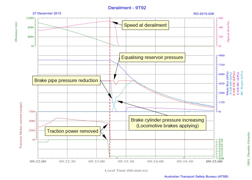
Plot of locomotive 2814 data log parameters. Plot illustrates driver actions in removing traction power immediately before train 9T92 enters the washed out track section. A rapid reduction in air pressure in the brake pipe occurs as train 9T92 traverses the washout and derails. Source: ATSB
Analysis of the data logger and ATP recordings by Aurizon engineering and maintenance staff showed that the reduction in brake pipe pressure did not correspond with a reduction in the equalising reservoir pressure. The movement of the brake handle by a driver toward the service or emergency position would typically cause both these pressures to reduce in unison.
The recorded events illustrate that a brake application, via the movement of the drivers brake handle to the emergency position (as recounted by the driver), did not cause the rapid reduction in brake pipe pressure. The reduction in brake pipe pressure was more likely due to a loss in brake pipe continuity during the derailment. The locomotive’s automatic brake control valve sensed the reduction in brake pipe pressure and began to apply the brakes on the locomotive.
While there is variance between the driver’s recollection and the data log analysis, the exact cause for brake pipe pressure reduction (brake handle or brake pipe continuity) had no material effect on the outcome of 9T92 entering the washout and derailing.
Rolling stock – tanker wagons
Incitec Pivot Limited was an accredited Rolling Stock Operator in Queensland[6]. Incitec Pivot operated the American made GATX tanker wagons. The GATX wagons were hauled under a hook and pull agreement with Aurizon.
The Incitec Pivot tanker fleet comprised 145 wagons, classified as OZSY class wagons. The fleet operated as 11 x 13-wagon strings plus two spare wagons. A product hose interconnected each tanker wagon within a string (Figure 5). This configuration enabled the stabling of the strings at Phosphate Hill and decanting of product as required.
Train 9T92 included wagon strings numbered four and seven. The strings were loaded with 399.9 m3 and 400.2 m3 respectively (819,000 litres in total) of Sulphuric Acid (>98%) at the Sunmetals Corporation facility at Townsville on 25 December 2015.
Figure 5: GATX tank wagons
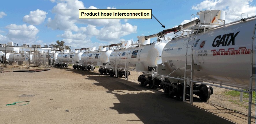
Image of a GATX tanker wagons coupled in a string and the product hoses interconnecting each vessel. Source: Incitec Pivot
The design capacity of each tanker wagon was 33,128 litres of product. The construction of the tanker shell was steel with a thickness of 12mm. The ellipsoidal tank heads were steel with a nominal thickness of 16mm. A phenolic resin coating protected the internal side of the tank shell and heads from a reaction with the product.
The tank wagons were generally grouped in a 3-unit configuration with a double-shelf coupler at each extremity and rigid draw-bar permanently interconnecting each unit. The provision of a Type ‘E’ double-shelf coupler was a safety measure commonly used in tanker wagons to prevent a vertical misalignment causing the accidental uncoupling of the knuckle. In the event of a derailment, an uncoupled knuckle may puncture the shell or head of an adjacent tank.
The design to prevent accidental separation of the coupling between tanker wagons can however lead to the sequential rollover of wagons in a ‘domino-effect’ during a derailment. As a wagon tilts, the torsional force transferred through each coupler (and rigid draw bar) progressively twists successive tanker units from their centre bowl mount in the bogie. Typically, this type of derailment would result in a number of the associated bogies remaining in situ on the track, while their corresponding bodies roll to the side (Figure 6).
Figure 6: Domino effect derailment of GATX tanker wagon string
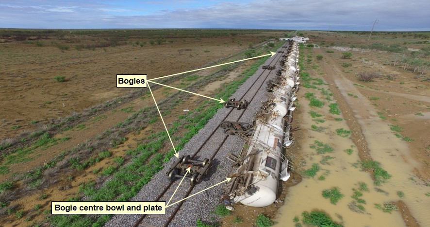
View of rear of 9T92 of the tanker wagons that derailed due to the ‘domino-effect’. A number of the associated bogies remained in situ on the track adjacent to the corresponding position of the tanker unit bogie mounting point. Source: Queensland Police
Derailment damage to tanker wagons in positions nine, eleven, and thirteen of the train caused sulphuric acid to escape (21,500 litres, 31,218 litres, and slightly less than 8,000 litres, respectively). The acid, 98 per cent pure, mixed with the surrounding floodwater and began to etch the damaged external surface of the tanker vessels within the acid pool hot zone[7] (Figure 7).
Figure 7: Acid hot zone
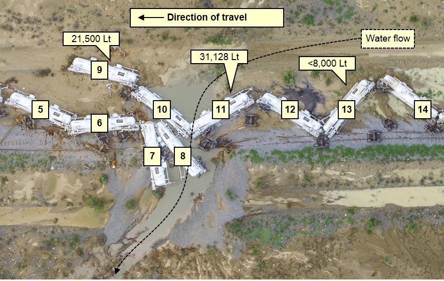
This image identifies the wagons that leaked product before restoration. Wagon 9 leaked 21,500 litres, wagon 11 leaked 31,218 litres (all contents), and wagon 13 leaked less than 8,000 litres. Source: Queensland Police Service. Annotated by ATSB
The etching resulted in further leakage of product, exacerbating the acid etching of the already damaged surfaces (Figure 8).
Figure 8: Acid etch damage to GATX tanker vessel
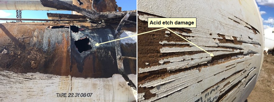
Images of acid etching to external surface of tanker vessel of GATX tanker wagon OZSY 44688. This tanker wagon was in position 11 of the train. Following the derailment, this tanker wagon was within the acid hot zone and lost all contents. Source: Incitec Pivot. Annotation by ATSB
Design standard
The GATX tanker wagons complied with QR requirements specified in the then QR Standard SAF/STD/0056/RSK-NET “Rail Tank Cars”. The standard reflected the requirements of the Railways of Australia Manual of Engineering Standards and Practices, and the Australia Code for the Transport of Dangerous Good by Road and Rail. The GATX tanker wagons were pressure vessels designed to the Australian Standard AS 1210[8] and maintained in accordance with AS 3788[9].
Maintenance records
The Incitec Pivot maintenance program included three levels of inspection:
- Level one – a basic walk-around inspection that occurred at Mount Isa, Phosphate Hill and Townsville
- Level two – An annual visual inspection undertaken at the maintenance facility in Townsville
- Level three – a seven yearly reline inspection undertaken at the maintenance facility in Townsville.
Incitec Pivot provided the ATSB with records detailing the annual visual inspections undertaken in mid-2015 and late 2015. The inspections incorporated wheel-set replacement, minor maintenance works and pressure tests to the tanker wagons in string four and seven respectively. Incitec Pivot also provided records of an overhaul in mid-2014 that included the relining of the vessels for the tanker wagons in string four.
On the 25 December 2015, a walk-around inspection and brake function test was completed at Townsville and the wagons in strings four and seven were certified fit for travel.
The examination of the maintenance records identified no anomaly in the condition of the rolling stock that may have contributed to the derailment of train 9T92.
Track information
Queensland Rail (QR) managed the railway where the derailment occurred, with the movement of rail traffic controlled from the QR Control Centre located at Townsville in Queensland.
The narrow gauge (1,067 mm) track at the derailment location consisted of 41 kg/m rail fastened to steel sleepers by resilient clips. The track formation was composed of black vertosol[10] soil overlaid with ballast to a nominal design depth of 200 mm forming the track bed.
Approaching the derailment site from Quarrels, the track was tangent and the terrain relatively flat and open. The track gradient was a falling grade of 1 in 1649, before transitioning to level through the area adjacent to the derailment location.
Track drainage at derailment site
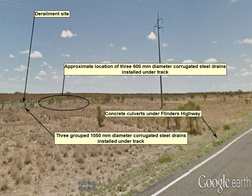
At the derailment site (617.190 km), there was a grouping of three 1050 mm diameter corrugated steel pipes installed under the track formation (Figure 9). Immediately west of the site three additional 600 mm diameter corrugated steel pipes were installed at about 10 m intervals (617.200, 617.210, 617.220 km).
Figure 9: Under-track drainage at the derailment site

Location of the derailment as it appeared before the event - viewed in a south-westerly direction from the Flinders Highway. Rainwater runoff flows from the catchment to the north, passes through a series of concrete culverts under the highway and toward the railway formation. A series of circular corrugated steel pipes installed under the track formation allows water to then flow into the watercourses located to the south of the railway. Source: Google Earth, annotated by ATSB
Queensland Rail (QR) advised that the group of three 1050 mm corrugated steel pipes were installed during the re-construction of the Mount Isa line completed in the early 1960s. In the 1980s a flood occurred that resulted in scouring of the formation adjacent the three existing pipes. This event resulted in the addition of the three 600 mm corrugated steel pipes to the west.
Track standards
The QR Civil Engineering Track Standard (CETS)[11] and Civil Engineering Structures Standard (CESS)[12] specified the safety standards and good practice guidelines for the construction and maintenance of track and structures owned by QR.
The standards noted that areas of the existing infrastructure may not meet the standards specified. Where a variance existed, the QR Rail Infrastructure Manager was to exercise sound professional judgement in the management of risk, rather than adhering to the literal application of specific detail contained in the standards. The QR Rail Infrastructure Manager was also required to ensure that the design of railway infrastructure broadly met the risk management intent of the standards.
With respect to track drainage systems, the structures standard provided guidance for monitoring and maintenance actions but was limited for design and construction. For example, the standard did not specify the QR design criteria for the standard of service (annual exceedance probability) used in designing track drainage systems. Typically, rail infrastructure managers specified the design of major and minor track drainage systems to accommodate an annual exceedance probability (AEP) of 1% or 2% respectively.
For minor track drainage systems, such as the corrugated pipe type drains installed along the Mount Isa line, QR had developed standard installation drawings. QR advised that the level of adherence to the standard installation drawings was at the discretion of the designer. Inclusion or modification of details contained in the drawings, for features such as head walls, aprons or flood rock protection, were dependent on an engineering assessment of the nature of the waterway. In effect, engineering design for the undertrack drainage was on a case-by-case basis. The final design relied on engineering judgement based on the known historical conditions for the location.
With respect to the track drainage systems near the derailment location, QR advised that based on local knowledge the designers decided not to install headwalls, aprons or flood rock, as the addition of the three waterway openings would adequately improve the site to handle localised flows. The selection of design features for the additional culverts was to match the existing waterway openings along the railway.
Queensland Rail (QR) could not provide records of the hydrologic modelling and hydraulic assessment for the location where train 9T92 derailed. Similarly, there were no records for the design criteria or the designed AEP flood immunity for the installed drainage infrastructure.
Track drainage inspections
The QR track and structures standards provided for multiple types of inspection:
- Scheduled Patrol
- Scheduled General Inspection
- Unscheduled Patrol
- Unscheduled General Inspection
- Unscheduled Detailed Inspection.
Assessment of infrastructure condition and actions necessary could then be determined using:
- Predetermined condition standards
- Predetermined assessment rules
- Engineering analysis.
Where the standards specified a condition standard or assessment rule, its application was mandatory to determine the required response.
With respect to drainage systems, the structures standard required scheduled inspection of culverts and other structures to assess their condition and monitor or action repairs.
A scheduled detailed inspection conducted on the 30 August 2015 of the corrugated pipes at the derailment location recorded a drain at the 617.220 km mark (600 mm diameter corrugated pipe) as ‘buried’. QR completed remediation work to clear the drain on the 15 September 2015.
The standards also required that condition standards or assessment rules determined for hazard locations must take into consideration the defined event that may require initiation of an unscheduled inspection. For example, a flood hazard location would require consideration of water levels, scour depths and water velocities to determine the condition standard or assessment rule applicable.
The track standard specified that unscheduled inspections must be undertaken at affected locations or operational restriction applied in response to environmental events such as:
- Heavy rainfall / inundation / floods / washaways / ingress of underground water
- Earth movements / subsidence / slops / earthquake
- Loss of track support, such as collapsing soils, culvert or structure failure, erosion
- Temperature extremes
In the hours prior to the derailment of 9T92, QR initiated unscheduled inspections of affected locations west of Julia Creek in response to information provided by the crew of 9E56 and the high water alarm at an automated monitoring station. For the area east of Julia Creek, the information received by the NCO from the train crew of 9T92 (reported overtopping at Spellary Creek) resulted in the NCO placing an operational restriction by closing the track behind 9T92 to enable a second track inspection to commence from Richmond.
Hazard locations register
The standards required the Rail Infrastructure Manager to prepare and maintain a Hazard Location Register. The register was to detail the hazards and the required action (such as unscheduled inspections) where defined events might rapidly reduce the capability of the track to safely perform the required function.
The hazard location register for the corridor between Hughenden and Cloncurry identified 40 individual locations. The identified hazards present at a location were either:
- The potential for track buckle
- Ineffective sleeper type
- The potential for fouling of ballast following periods of heavy rainfall
- Track alignment
- Formation failure due to animals (foxes) digging.
The hazards identified near the derailment location were foxholes at the 617.420 and 618.270 km points.
In this case, QR initiated unscheduled inspections in response to potential flooding hazards both east and west of Julia Creek. However, the hazard location register showed no location identified between Hughenden and Cloncurry where a floodwater runoff event may result in a hazard to infrastructure.
Flinders Highway
The Flinders Highway extends around 754 km between Townsville and Cloncurry. The route of the highway and the Mount Isa railway follow a similar corridor for much of their length. At the location of the derailment, there was a separation of around 90 m between the road and rail alignment.
The Department of Transport and Main Roads (TMR) was responsible for the management of the road infrastructure. The Flinders Highway was susceptible to frequent closures caused by inundation following rainfall events, particularly during the annual wet season from November to March.
To improve the resilience of Flinders Highway, TMR commissioned a number of flood studies. The objectives were generally to identify flood delay priorities from closures, setting of performance targets for flood immunity across the road corridor and the prioritising of associated infrastructure projects.
There was limited hydrological data available for the various catchments along the corridor as many of the waterway crossings on the Flinders Highway were unmetered. TMR flood studies used historical data and local knowledge to develop hydrologic models on which to base flood assessment and the prediction of flow thresholds for road closure at key waterway crossings.
TMR flood studies identified a number of segments of the Flinders Highway between Townsville and Cloncurry that were prone to flooding. The Richmond and Julia Creek segment was not the most flood prone section but, on occasion had the potential to be significantly affected by road closures due to inundation (Figure 10).
Figure 10: Flinders Highway road closures per year between Richmond and Julia Creek
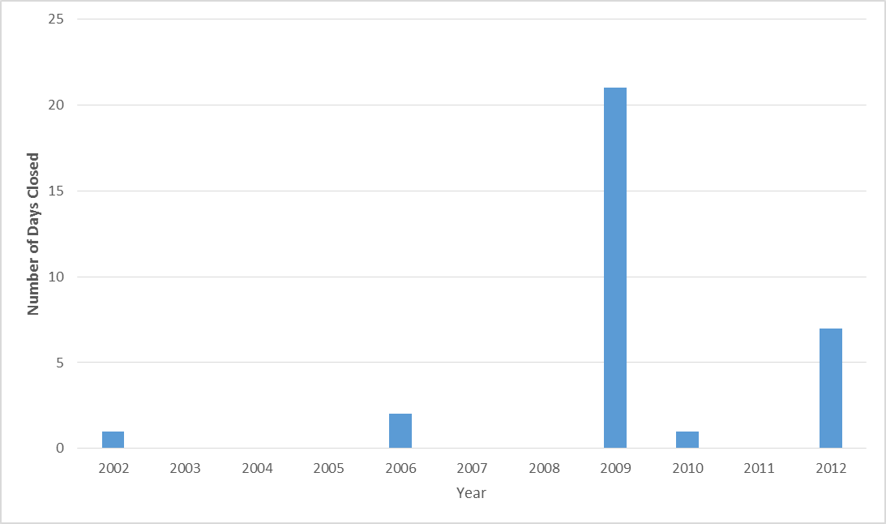
Illustration of the number of days each year that rainfall runoff inundated the Flinders Highway at locations between Richmond and Julia Creek, resulting the closure of the highway to road traffic. The 2009 year shows a significantly larger number of days closed, which aligns with severe flood events in the region (due to active monsoon trout that developed into tropical cyclones Charlotte and Ellie). Source: Queensland Department of Transport and Main Roads data, plotted by ATSB
The Richmond to Julia Creek segment contained the Alick, Spellary, Horse and Julia Creek waterways. The TMR flood study found that this segment of the highway had an overall 0.5-year ARI (86.47% AEP) flood immunity, with the Alick Creek crossing overtopping on frequent occasions.
The Mount Isa rail line ran roughly parallel to the Flinders Highway between Richmond and Julia Creek. The elevation of the rail track formation varied between 1.0 and 1.5 m higher than the adjacent highway. A review of QR records indicated the rainfall events during 2009 and 2012 that had closed the Flinders Highway also resulted in the closure of the railway on several occasions. These closures followed reports of rising water levels under rail bridges or overtopping of the track formation at the Alick or Spellary Creeks. These closures did not correspond to any report of damage to rail infrastructure.
Water catchment adjacent derailment site
TMR flood studies identified five major river basins and 32 individual catchments adjacent to the Flinders Highway between Stuart and Cloncurry. The catchment adjacent the derailment site included land areas located to the north and south of the Flinders Highway (Figure 11). The waterway at the derailment site flowed from the north to south into tributaries feeding Horse Creek. The Horse Creek subsequently flowed from south to north, crossing the Flinders Highway before joining to Julia Creek north of the Julia Creek Township.
Figure 11: Catchment Delineation Julia Creek area
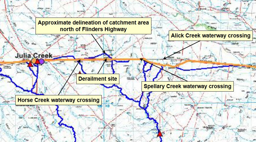
Extract from Flinders Highway Flood Study Catchment Delineation – Richmond to Cloncurry. Image illustrates catchment area to the north and south of the Flinders Highway at the derailment site. Source: Queensland Department of Transport and Main Roads
The catchment land area to the north was a relatively flat plain with sparse vegetation. As much of central Queensland was in drought following below average rainfall since 2013, the catchment area was largely devoid of vegetative cover. This likely affected the amount of rainwater infiltration into the soil, subsequently increasing the overland flow of runoff from the catchment north of the highway and railway following a rain event (Figure 12).
The runoff followed south, crossing the Flinders Highway at two locations into excavated channels that directed the flow toward the location of drainage pipes under the track formation. At the location of the derailment, the two drainage channels converged the outflow from culverts under the Flinders Highway toward the under track drainage pipes.
The location of the under track drainage pipes was at the point of lowest elevation of the surrounding ground surface in the immediate area. As the construction of the track formation generally followed the elevation of the ground surface through that area, it was likely that the location of the derailment also corresponded to the lowest longitudinal vertical alignment of the track formation.
Figure 12: Northward view of catchment area and watercourses
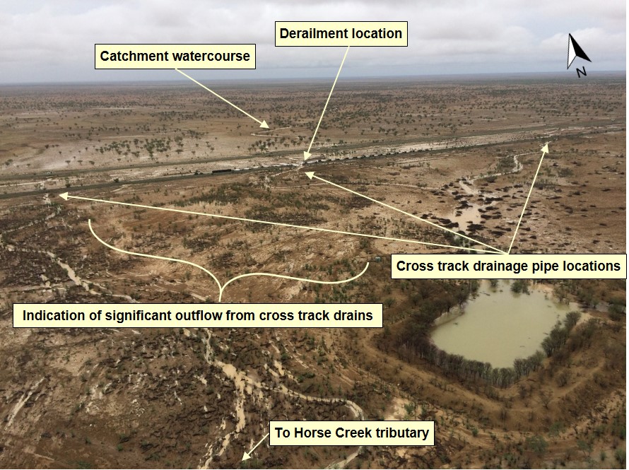
Northward view of the catchment area and associated water courses that cross the Flinders Highway and the Mount Isa railway. The view shows the path of floodwater outflow from the cross track drains adjacent the derailment site. Source: Queensland Police
The train crew of 9E56 and 9T92 had both reported periods of heavy rainfall and areas of ponded water at locations next to the track formation enroute to Julia Creek. The crew of 9T92 reported that water had overtopped the track at Spellary Creek before receding to the level of the shoulder at the top of the ballast formation.
Approaching the derailment site, the train crew of 9T92 recalled observing water ponded on either side of the track formation. The water did not appear to be flowing and the depth was equal on either side of the formation, about 500mm below the top of the rails.
The train crew noticed that there was no ballast covering the top of some sleepers ahead, which was abnormal for this track section. The surrounding ballast, being wet, appeared black in colour but a section about 6.0 m wide of formation ahead, that also appeared black, had a different texture. This was the washed out track section.
When the locomotive derailed into floodwaters on the northern side of the track, the train crew recalled the cab filling with water to a depth of about 600mm. Watermarks on the locomotive supported the estimation of depth (Figure 13)
After evacuating the locomotive cab, the train crew had to walk about 800 m toward Julia Creek to avoid ponded water between the track and the highway. A crewmember recounted sighting evidence of inundation along the highway that extended for a distance of around 300 m immediately to the north of the derailment site. There was no estimation of the depth of water that had overtopped the highway at that location.
Figure 13: Approximate water depth following derailment
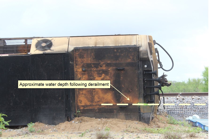
Watermark on the locomotive indicating the depth of the floodwater. Source: Queensland Rail
Based on the observed depth of water following the derailment, and evidence of sediment and scouring south of the track from water outflow (from under track drains and the washout), it was likely the level of floodwater that damaged the track formation was higher than was present at the time of the derailment. It is likely that water had banked up against the track formation, and the water level receded once the formation had washed away.
Environmental conditions
During 26 and 27 December 2015, the BoM was monitoring an active period of tropical weather that was affecting the Gulf of Carpentaria and surrounding inland, including north –western Queensland (Figure 14). The BoM analysis of the synoptic weather conditions, which gave rise to the rainfall near the derailment, found that:
A tropical low-pressure system located over the top end of the Northern Territory was moving slowly east during the period. This low extended a monsoon trough east through the far southern Gulf of Carpentaria, across southern Cape York Peninsula, and into the northern Coral Sea. Elsewhere, a cold front moving through south-eastern Australia extended an inland trough through western Queensland, which was located over inland north-western Queensland through the period. The atmosphere over north-western Queensland was moist and unstable and conducive to heavy rainfall, as is common in northern Queensland in late December.
The monsoon trough and the inland trough together provided triggers for widespread shower and thunderstorm activity during the period, particularly overnight on Saturday 26th December and in the early morning of Sunday 27th December.
Figure 14: Mean sea level weather chart at 1100 on Sunday 27 December 2015
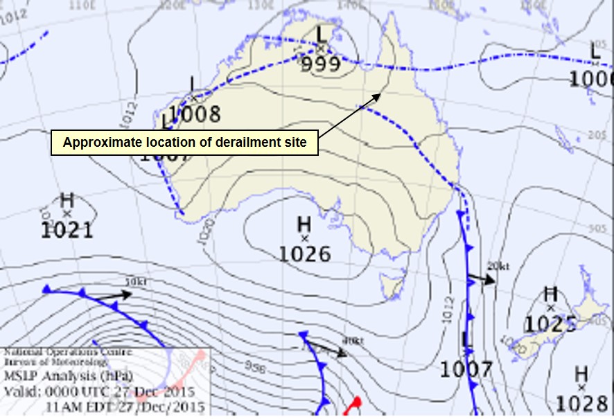
Image shows the approximate location of the derailment site relative to the path of the tropical low-pressure system tacking eastward across the Gulf of Carpentaria and the trough from the cold front extending into inland north-western Queensland. Source: Bureau of Meteorology
The BoM had issued a series of localised severe thunderstorm warnings that included the potential for heavy rainfall and flash flooding for the North West district, which included the area around Julia Creek. It was common for the BoM to issue localised thunderstorm warnings during the northern wet season.
The rainfall measurement network is very sparse in the region near the derailment. The closest BoM weather station was at Julia Creek (Julia Creek Airport), about 23 km west of the derailment site. To 0900 on 27 December 2015, Julia Creek Airport recorded a daily rainfall 60.2 mm. The next nearest rain gauges with available data were at Corella Creek (about 24 km to the east) and Punchbowl (about 27 km to the north-northeast). These stations recorded rainfall over the same period, of 104 and 48 mm respectively.
The BoM rain gauge at Proa, located about 33.5 km to the southeast of the derailment site, recorded rainfall of 140 mm. This gauging was the record for the highest December daily rainfall at that station.
Post-incident analysis by the BoM concluded that the rainfall recorded from the weather event in the North West forecast area was typical of an Annual Exceedance Probability (AEP) of 9.5%. An AEP of 9.5% equates to an Average Recurrence Interval (ARI) of 10 years.
Queensland Rail risk management
The QR Enterprise Risk Management System (RMS) mapped relevant procedural and engineering controls against identified hazards. In February 2015, QR initiated a complete redesign and rebuild of the RMS. A tiered roll out the revised RMS through the business then commenced and was ongoing at the time of the derailment of 9T92.
Queensland Rail (QR) was aware that during the rollout of the RMS, the level of detail and maturity of the risk registers would vary due to factors, including by not limited to the:
- Assigning of risk resources as a priority to higher risk areas of operation (passenger)
- Access to subject matter expertise and a distributed delivery network
- Working in a top down methodology addressing policy and administrative controls initially.
In managing risk associated with a derailment, QR developed a risk profile that addressed the management of rail infrastructure to prevent a ‘major avoidable event’[13]. The risk profile included a series of subset registers grouped under the headings:
- Signalling and Operational Systems Discipline
- Track and Structures Discipline
- South East Queensland Track and Civil risk register
- Supply Chain North Risk Register
- Risk Management Risk Register.
On 16 December 2015, QR management at Townsville approved the subset of risk assessments linked to the Supply Chain North Risk Register, which included the rail infrastructure on the Mount Isa railway.
The assessments identified the risk from derailment caused by a number of factors that included damage to a bridge, culvert, track formation, or ballast from flooding. The associated treatments linked to various procedural controls contained in the QR track and structures standards (CESS and CETS). These controls primarily related to the inspection of track, competencies of network staff and network assurance audits.
The assessment recorded the risk as ‘high’ for ‘track failure or irregularity’, due to the onset of the wet season and the increased potential for flooding. However, the risk reduced to ‘medium’ for the dry season, since the assessed likelihood that a track failure would occur had diminished.
Assessments for the Track and Structures Discipline identified a related risk where track and structures standards/specifications did not adequately address the required reliability and safety of structural components. The identified causes associated with this risk were:
- Track & Structures standards and specifications are incomplete or inadequate
- Track & Structures specifications may be missing or not yet identified as necessary
- Track & Structures standards and specifications are not maintained.
The risk treatments similarly linked to procedural controls within the standards. The modules contained within the structure standards (CESS) specified the construction, inspection, and maintenance requirements for structures that included corrugated steel pipe under track drainage systems. QR assessed these controls would also reduce the risk of derailment to a rating of ‘medium’.
For an assessed risk score of high or medium, QR’s processes require the ongoing monitoring of controls through network assurance audits.
The controls applicable to construction included the QR practice for undertaking engineering design work. With respect to under track drainage, this work was not only reliant on the application of the relevant standards but also on the application of engineering judgement based on the historical conditions at a particular location.
The standards did not adequately define the requirements for undertaking hydrologic modelling and hydraulic assessment. Similarly, the standards did not include the requirement to document the specifications or design criteria of the drainage infrastructure specifying the designed flood immunity for areas of the Mount Isa line, such as a culvert location, where 9T92 derailed.
Although the QR Enterprise Risk Management System included the identification of hazards and the management of risk to prevent a major avoidable event, (derailment) caused by a number of factors that included damage to a bridge, culvert, track formation, or ballast from flooding, QR advised that there was no legal requirement to know the flood immunity at a particular location.
Queensland Rail wet weather operational procedures
Queensland Rail (QR) had implemented a variety of management systems and operational procedures/protocols to assist staff to detect and respond to a weather event that may affect the network. At the Townsville control centre, staff had available historical flooding information, trackside weather monitoring station information and BoM data for the district encompassing the Mount Isa railway.
Identified flood hazard areas
Operations staff at the control centre in Townsville referred to the Flood Hot Spot Information record to identify the location of areas prone to flooding. Staff also accessed trackside weather monitoring stations installed along the rail corridor to detect a defined weather event (Figure 15).
Between Richmond and Julia Creek, the hot spot information identified one flooding hot spot located between the 590 and 601 km points that encompassed the Corella and Alick Creeks. There was no record of a flooding event at the derailment site since the early 1980s, after which QR installed the three additional 600 mm drains. QR did not consider this location to be a flooding hot spot.
Figure 15: Great Northern Line flood spot information

Map showing locations of weather monitoring stations and identified flood hotspot areas. Weather stations indicated by green markers. Areas identified as prone to flooding identified by blue markers. Source: Queensland Rail
Queensland Rail (QR) advised that the document was general in nature and developed as a guidance tool for operational staff at the Townsville control centre. Updating the document to add a location in the record as a hot spot was dependent on local knowledge of the terrain and historical information of previous flooding occurrences. The Flood Hotspot Information was last updated in 2011 and was independent of the Hazard Location Register maintained by the QR Rail Infrastructure Manager.
The hazard register maintained by the Rail Infrastructure Manger did not reflect the 16 hazard locations identified by operational staff as prone to flooding between Hughenden and Cloncurry.
Weather monitoring systems
Trackside weather monitoring stations
The nearest QR trackside weather monitoring stations to the derailment site (617.190 km) were located Corella Creek (593.00 km) and Eastern Creek (658.620 km). The weather stations incorporated the following alarms to detect rainfall and flooding:
- Heavy Rainfall, calibrated to detect a rainfall rate that exceeded 100mm/h for more than 5 minutes
- One-hour total rainfall, calibrated to detect a rainfall over the last hour that exceeds 50 mm
- Flood alarm, configured to detect pre-set measurements of water levels relative to the rail and current rate of rise or fall of the water level with the alarm.
The Townsville Train Control Centre was responsible for actioning any alarms received from the trackside weather monitoring stations. The measurement of water levels relative to the rail was available for display on monitors located at the Regional Transit Managers workstation (Figure 16).
Figure 16: Corella Creek graph of measured water level under rail
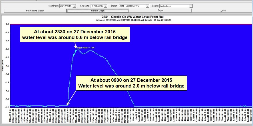
Graph of data from the Corella Creek weather station illustrating of rise in water level under the rail bridge at that location. After the passage to train 9T92, the water level rose about 1.4 metres over the next 14 hours to a level around 0.6 m below the rail level. Source: Queensland Rail
Information of rainfall recorded at a trackside weather monitoring station was also available for display to the Regional Transit Manager. The display was configurable to indicate rainfall information as an hourly rainfall rate or as hourly, daily, monthly totals.
For the 12-hour period to 0900 on the morning of the 27 December 2015, the weather station at Corella Creek recorded a rainfall of around 104 mm. The BoM estimated the intensity of the rainfall recorded at Corella Creek to an ARI of between 5–10 years.
Prior to the passage of 9T92, the intensity of the rainfall and water level measured was below the calibrated threshold to trigger an alarm at the Corella Creek weather station. There were no data available from the Eastern Creek weather station, as it was not functioning at the time of the derailment due to faulty sensors.
The Regional Transit Manager was unlikely to have identified a potential hazard to train 9T92 based on information from the Corella Creek trackside weather station.
Bureau of Meteorology data
In addition to the trackside monitoring systems, the Townsville control centre operational staff had access at each workstation to BoM weather information that included rainfall observations and radar images.
Plan Position Index radar reflectivity imagery
An overview screen, visible from various areas of the control centre (including the far west control board) displayed selected radar loops (Figure 17). The images displayed on this monitor were configurable from the Regional Transit Managers workstation.
Figure 17: Monitor at Townsville Control Centre displaying BoM radar images
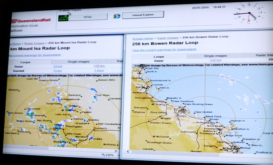
Image of displayed BoM radar loops available to the QR staff at the Townsville Train Control centre. The screens displayed provide an overview of the area containing the Great Northern Rai line. The image does not represent the radar loop at the time of the derailment of train 9T92. Source: ATSB
The radar images do not display cloud formations but depicted echoes received from rainfall droplets produced by the clouds. These images provided an effective tool to determine the location of rainfall relative to points along the railway.
The radar image also displayed an indication of the intensity of the rainfall through the colour of the formation. The colour displayed corresponded to an approximated rainfall intensity in mm/hr at that location. Colours ranged from Off-white to Dark Brown indicating rainfall intensities of under 0.5 to over 360 mm/hr respectively.
Shortly after the passage of 9E56 through Quarrels (about 0400) and the shift change by NCOs, the incoming NCO recalled observing the BoM Mount Isa radar loop that indicated heavy cloud cover (rainfall) to the north-west of Julia Creek. The NCO recalled the display showed nothing of significance near the railway east of Julia Creek, where the derailment occurred. Nothing seen on the radar images raised any immediate alarm with the NCO about the presence of a potential hazard from the weather conditions.
At the commencement of their shift, the train crew of 9T92 had also monitored the BoM website, via their personal electronic devices, to identify likely weather conditions for the track ahead. A crewmember recalled that the BoM images showed some indication of rainfall, which they considered was normal for the time of year.
The rainfall distribution appeared light to medium colour shadings, with only a couple of areas showing heavy falls. The crewmember also checked the weather stations to the west noting rainfall recordings of around 30 mm up to 40 mm at Richmond. Nothing seen on the BoM website raised any immediate concern with the train crew about the presence a potential hazard from the weather conditions.
Post derailment data analysis
The BoM undertook post derailment analysis of the prevailing weather conditions for the north-western area of Queensland on the morning of Sunday 27 December 2015. The analysis used information from Mean Sea Level Pressure charts, Radio sonde devices and combined infrared imagery from the Himawari-8 geostationary satellite and radar reflectivity imagery.
The information indicated a considerable amount of moisture and instability in the tropical atmosphere and the presence of heavy cloud cover and an intense cluster of thunderstorms in a rough line south of Cloncurry in the west to south of Julia Creek in the east (Figure 18). For several hours from about 0130 on Sunday 27 December thunderstorms and rainfall in the general area of the derailment appeared to be at a peak
Figure 18: Combined satellite and radar reflectivity imagery over north-western Queensland at 0430
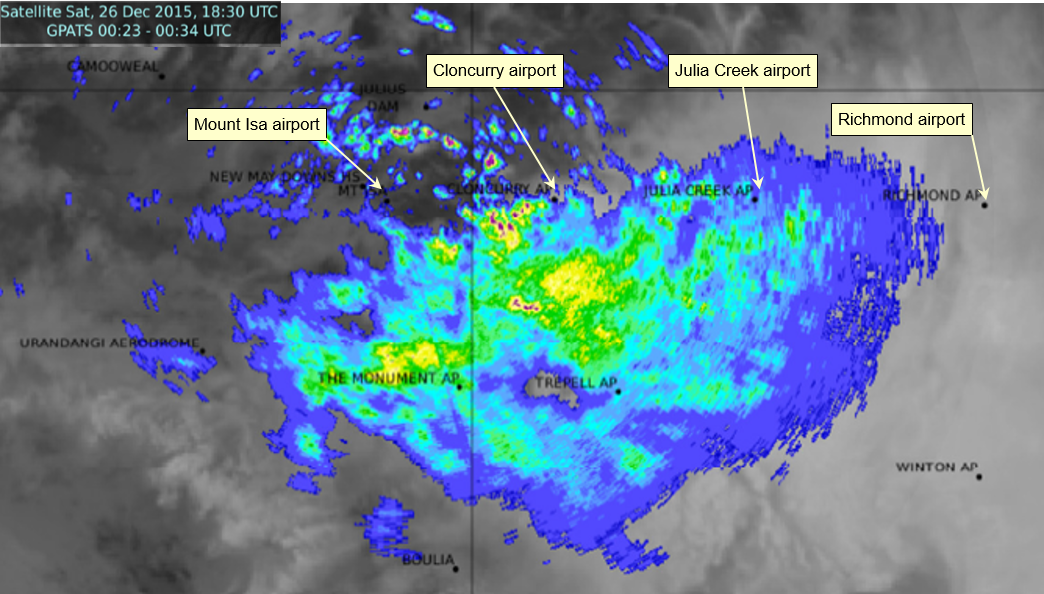
Image depicts cloud cover at 1830UTC Saturday 26 December 2015. This equates to 0430 AEST on Sunday 27 December 2015, about 5 hours before the derailment of 9T92. Colour on image blue through green/yellow to red indicate increasing rain rate from light toward Heavy. Source: Australian Bureau of Meteorology
By about 0730 on Sunday morning, the intense storms appeared to have weakened considerably, though areas of rain and showers persisted about the Julia Creek area for the remainder of the morning – most notably to the east of Julia Creek between 0800 and 0930 prior to the passage of 9T92 through Quarrels (Figure 19).
In assessing the likely rainfall, BoM advised that optimal radar coverage areas typically extend approximately 200 km away from the radar location. The derailment of 9T92 occurred around 250 km east of the Mount Isa radar installation.
Based on the distance between the radar installation and the location of the derailment, the BoM cautioned that:
At this distance, radar detection loses accuracy and generally underestimates actual rainfall intensities at the ground due to a combination of radar beam broadening with distance and subsequent partial beam filling by discrete storm cells earth curvature causing the radar beam to sample only the storm tops.
The fact that significant radar returns were measured at this distance could indicate the presence a very intense rainfall, but this is by no means certain.
Figure 19: Combined satellite and radar reflectivity imagery over north-western Queensland at 0830
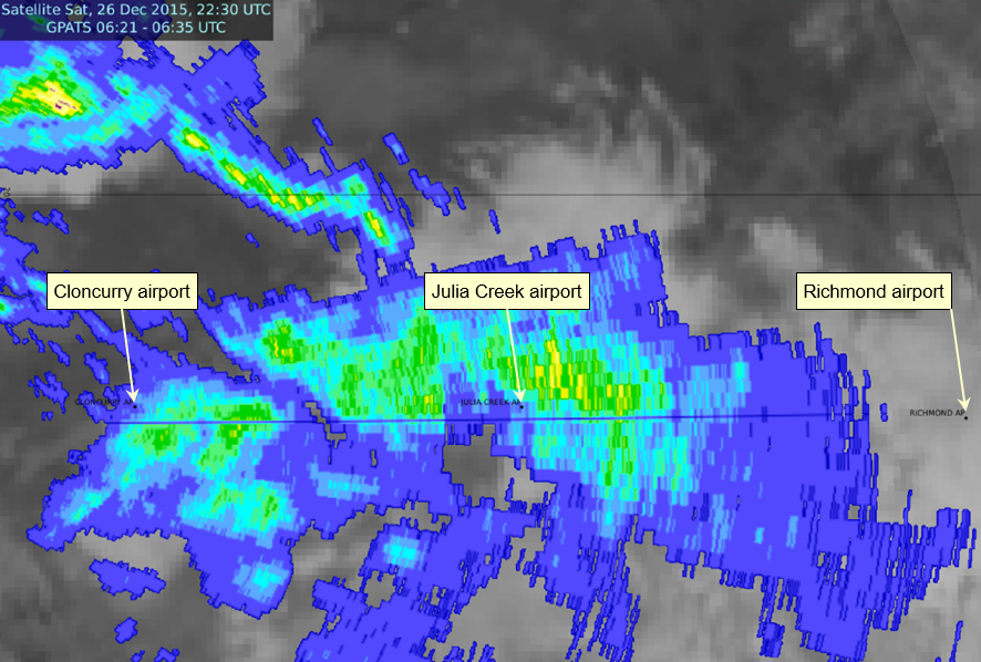
Image depicts cloud cover at 2230UTC Saturday 26 December 2015. This equates to 0830 AEST on Sunday 27 December 2015, about one hour before the derailment of 9T92. Colour on image blue through green to yellow indicate increasing rain rate from light toward moderate. Source: Australian Bureau of Meteorology
Radar imagery – optimal coverage limitations
The operational staff at the Townsville control centre referenced the BoM weather radar installations at Mount Isa, Townsville and Bowen to identify weather conditions along the Mount Isa railway. At the 256 km radius webpage view, the Mount Isa radar provided coverage that extended to around Richmond. The Townsville and Bowen radars provided 256 km radius coverage that extended a short distance west of Charters Towers. Radar coverage of the entire Mount Isa line was only available through composite view of radar images. However, the BoM advised that optimal coverage only extends to approximately 200km away from the radar and can be further restricted due to hills or mountains. The area of optimal radar range for each radar that provided coverage for the Mount Isa line was considerably less that the views typically accessed by operational staff at the Townsville control centre (Figure 20).
Staff at the Townsville control centre and train crews operating on the Mount Isa railway accessed the BoM weather information to identify weather conditions that may affect the network. Considering the limitations of the BoM weather radar images and the absence of formal training, their assessment of likely conditions relied on a combination of the individual’s interpretation of information and possibly their local knowledge.
An over reliance on the individual interpretation of radar images to obtain predictive information could result in the underestimation/inconsistency in assessment of likely hazard posed by weather present along the railway.
Figure 20: BoM radar optimal coverage areas - Queensland
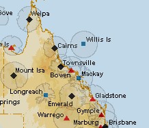
Image shows the optimal coverage areas surrounding BoM weather radar installations in Queensland. Queensland Rail references images from the Mount Isa and Bowen weather radars to identify weather conditions that may affect the Mount Isa railway. Source: Bureau of Meteorology
BoM weather warnings
The QR Regional Transit and Freight Operations managers at the Townsville operations centre received weather warnings published by the BoM.
For a weather event, such as a Monsoonal Low affecting coastal and inland areas, the BoM issues a suite of warnings for one or all of the following:
Severe Weather Warnings for the following potentially hazardous or dangerous weather that is not directly related to severe thunderstorms, tropical cyclones or bushfires:
• Sustained winds of gale force (63 km/h) or more
• Wind gusts of 90 km/h or more
• Very heavy rain that may lead to flash flooding (taken to be an hourly rainfall which equals or exceeds that which recurs on average once every 10 years)
• Abnormally high tides (or storm tides) expected to exceed highest astronomical tide
• Unusually large surf waves expected to cause dangerous conditions on the coast.
To warrant a Severe Weather Warning, the dominant mechanism causing the above phenomena should be a synoptic-scale weather system, not localised severe thunderstorms.
Severe Thunderstorm Warnings for the following potentially hazardous or dangerous weather:
• Large hail (greater than 2 cm in diameter)
• Damaging wind gusts (generally wind gusts exceeding 90 km/h)
• Heavy rainfall which may cause flash flooding
• Tornadoes
Flood Watch Products to provide early advice of potential riverine flooding to communities at risk.
Flood Warning Products to provide advice that riverine flooding is occurring or expected to occur in a geographical area based on defined criteria. Flood warning products may include either qualitative or quantitative predictions for defined forecast locations or a more generalised statement about current and expected flooding at forecast and information locations.
These warnings are to alert communities in the forecast area of a potential threat from a weather event.
The Regional Transit Manager and Manager Freight Operations at the Townsville control centre receive weather warnings issued by the BoM. In the days preceding the derailment of 9T92 (26 and 27 December 2015), the BoM assessment of the weather conditions identified the presence of localised severe thunderstorms. This resulted in the broadcast of a series of Severe Thunderstorm Warnings at various times (Figure 21, with details of each warning included under Appendix A).
Figure 21: Timeline of weather warnings issued on 26 and 27 December 2015 for the Julia Creek area
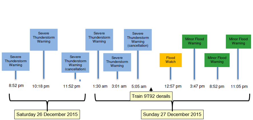
Image depicts the time line for the issuance and cancellation of severe thunderstorm warning, which included the warning of potential flash flooding. An advice for the cancellation of severe weather warnings occurred about 4 hours before train 9T92 encountered the washout and derailed. Source: Bureau of Meteorology, annotations by ATSB
Around the time of the cancellation of the Severe Thunderstorm Warnings (0505) train 9T92 was approaching the passing loop at Marathon, about 170 km from the derailment site. There was no Severe Weather Alert, Severe Thunderstorm or Flood Warning current for the Julia Creek area at the time 9T92 derailed.
In addition to BoM weather warnings, customised weather alert services were also available to provide a range of predictive warnings/alerts of weather events. QR was using the alert services to provide predictive information on thunderstorm activity that may occur in the South East QR network area. This information assisted QR to plan contingency arrangements for delivery of passenger services in the event of power outages.
There was no arrangement with an alert service to provide information that could assist operational staff at Townsville to assess the potential risk from rainfall, flooding or flash flooding at locations along the Mount Isa line.
Disaster Management
In the event a situation is declared a disaster, the Department of Transport and Main Roads undertakes the lead in implementing the Queensland Disaster Management Arrangements applicable to transport systems. The type and severity of the situation determines the level of response that QR was to provide in support.
The QR disaster management plan[14] outlined the roles and responsibilities within QR and its relationship with other stakeholders in responding to any declared disaster. The response to an emerging event comprised a three-tiered structure involving emergency management, coordination and response by appointed teams.
To assist in providing a timely and effective response, region specific plans for preparedness, response and initial recovery actions were included for disaster events involving:
- Severe Weather (incl. heavy torrential rain/strong winds)
- Flooding (incl. flash flooding/rising water)
- Cyclones (incl. tropical lows)
- Fire
- Earthquake
- Tsunami.
On advice from the BoM, Emergency Warning Network or other relevant weather warning systems of an approaching severe storm, heavy torrential rain and/or high winds, the plan required the network control centre to implement processes to prepare, respond and if necessary recover from that event. Preparations for severe weather and flooding involved the:
- Monitoring of emergency warnings, threat alerts, media and operational warning systems and advice from BoM.
- Monitoring creek and river levels and weather conditions in the region
- Identifying potential impacted locations
- Advising Rail Traffic Crews and work crews on the network of the approaching threat
- Reviewing train manifest and Train Diagrams concerning dangerous goods, hazardous goods, explosives and passenger train services considering the level of risk imposed by the severity of the event.
- Reviewing flood prediction maps to determine potential impact
- Developing plans to manage risks to train services on or approaching the section/corridor.
Prior to the derailment of 9T92, there were warnings for severe thunderstorms and the potential for flash flooding. However, there was no synoptic scale weather system to trigger a Severe Weather Warning, or the declaration of a disaster, to activate the Queensland Disaster Management Arrangements for the Cloncurry, McKinlay or Mount Isa districts[15].
QR Operational rules, procedures and safety manuals
Queensland Rail (QR) developed a suite of operational standards, rules and procedures that specified the requirements for the safe operation of rai traffic on the rail network. The General Operational Safety Manual, MD-10-107 and Queensland Network Rules and Procedures, (QNRP) MD-12-189 provided information and guidance on conditions affecting the network. Section 2009 of QNRP prescribed the rules for reporting and responding to unsafe conditions affecting or potentially affecting the network. A key element of the rules was the prompt reporting of conditions that can or do affect the safety of operations to the NCO.
If necessary, the Competent Worker[16] identifying such a condition must prevent rail traffic from approaching the affected portions of the line and apply protection for rail traffic.
On receipt of a report or when becoming aware of conditions that may affect the safety of operations, the NCO was required (as necessary) to respond by managing the conditions as a Condition Affecting the Network[17] by:
- Notifying the nominated Operators’ Representatives
- Arranging to warn rail traffic crews approaching the affected portions of the line
- Arrange to prevent rail traffic from approaching the affected portions of the line and apply blocking facilities as necessary
- Ask Maintenance Representatives to investigate
The general operational safety manual contained advice and guidance to train crew and NCOs for the operation of rail traffic under adverse conditions caused by:
- Heavy rain
- High wind
- Reduced visibility from fog or smoke.
The train crew were required to operate rail traffic to suit the current conditions and advise the NCO when encountering such conditions. The NCO in turn was to consult with train crew, track supervisors, and any other resources available to determine factors that may affect the running of rail traffic. Where information was available to Network Control indicating an issue, the NCO could stop traffic or impose special conditions that include:
- Continual monitoring
- Restricting speed
- Increased exchange of information to ensure safety
- Updates on changes in weather conditions.
The QR general operational safety manual also contained an instruction to train crew for the working of rail traffic through flooded areas[18]. Flooded areas related to situations where running or still waters were overtopping the rails. The instructions specified the restrictions where it was necessary to operate rolling stock through the floodwater. This could only occur however following an inspection of the track and approval by operations management. No guidance was provided to train crew for situations where floodwater had overtopped the track and then receded.
On the 27 December 2015, the floodwaters were not overtopping the track at Spellary Creek when encountered by 9T92. However, the train crew identified that water has previously overtopped the track and therefore bought their train to a stop. After assessing and discussing the current conditions, the train crew proceeded through the area at low speed, before reporting to the NCO.
Supplementary to the QR rules and procedures, the Townsville Regional Safety Committee published a set of wet weather protocols for use by NCOs in the Townsville Control Centre. These protocols provided additional guidance to the NCO for the stopping of trains when conditions were uncertain, or until track inspection verifies the infrastructure is safe for traffic.
The protocol identified that the NCO may stop trains if ‘water is in the ballast’. The protocol did not clearly specify a level of water relative to the ballast that would trigger a decision to stop trains. The NCO responded to the train crew report that water had previously overtopped the track by closing the track west of Richmond and arranging a track inspection of the area.
The train crews reported observations of periods of heavy rainfall enroute and floodwaters at Spellary Creek. The NCO and train crews responded generally in accordance with the guidance available in the QR rules and procedures for conditions affecting the network.
The application of the rules, procedures or protocols did not assist the NCO or train crew to identify the magnitude of the potential hazard that existed ahead of train 9T92 from this weather event or describe the response when encountering water that had previously overtopped the track and receded or was pooled against the formation (ballast).
Aurizon operational procedures
The Aurizon operating plan[19] defined the services provided by Aurizon for the operation of sulphuric acid trains between Townsville and Phosphate Hill. The operations plan contained information related to the resourcing, rolling stock information and other service information. The operations plan augmented local procedures, and the infrastructure managers (QR) rules and procedures and general operational safety manual.
Aurizon Risk identification
The Aurizon procedures for the management of hazard and risk[20] listed natural influences arising from cyclones, flooding, or heat as hazards that may (due to the changing conditions) result in an incident.
The risk treatments identified by Aurizon were principally dependent on the effectiveness of the infrastructure manager’s (QR) procedures for:
- Track inspections
- Monitoring of river/flood heights
- Track design to limit impacts of natural influences
- Track upgrade program
- Train control protocols.
The risk arising from derailment on the main line caused by washaway/flooding identified like treatments that were also dependent on the infrastructure manager’s procedures. Aurizon incorporated the following additional procedures to mitigate risk:
- Driver training and competency
- Reporting of hazards
- Route knowledge
- Dangerous Goods regulations.
Supplementary to the above, Aurizon proposed that the introduction of its representative into the infrastructure manager’s network audits would aid in gaining a thorough understanding of track condition and the management of associated issues.
Aurizon assessed the treatments would mitigate the risk associated with natural influences and derailment caused by washaway to a residual risk level of moderate.
Driver training
To raise awareness of the various mechanisms leading to a derailment, the Aurizon Derailment Prevention Community of Competence (CoC) provided an information package[21] to rail safety workers. The package included sections on derailment incidents attributed to Flooding and Washouts and Water Damage and Obstructions.
For flooding and washouts, the package identified that:
- Heavy rainfall occurrences can cause unexpected events like flooding and washouts, which can be further compromised by reduction in driver visibility.
- An extreme rainfall event or floodwater trackside should be immediately reported to control as it may affect the track integrity affecting the safety of the train and its crew. The consequences of a derailment in these conditions can be significant.
- The installation of trackside weather monitoring stations with automatic alarms is one way that the track maintainer is trying to control the risk of these events.
- Any running water on or approaching ballast should be reported to control or road infrastructure to inspect.
Should a driver encounter conditions outlined above the recommended “do’s and don’ts” for driver reaction included:
- Know the road
- Be more vigilant after rain
- Stop if it is unsafe and walk
- Wait for a track supervisor
- If a driver can’t stop, hit the generator field switch to remove power
- Don’t drive though water.
The key learning was that if a train crew had issues with limited visibility or concerns with the condition of the track (including water and high or extreme winds) they should notify the network controller with their concerns.
The section pertaining to water damage and obstructions contained similar information to the above reinforcing the key learning of not to drive locomotives over track where water was overtopping the sleepers.
The CoC also produced a series of training videos providing advice to train crew for the prevention of derailment. In 2013, an Aurizon iron ore train was involved in a derailment caused by a washout to a wide section of track from floodwater runoff near Salmon Gums, 140 km north of Esperance in Western Australia. The floodwater runoff resulted from a localised thunderstorm event that caused heavy rainfall.
On this occasion, the locomotives remained on track but around 30 of the 160 loaded iron ore wagons derailed. The Aurizon training video attributed the locomotive remaining on track and wagons not piling up, by the crew (on this occasion) being able to control the locomotives speed and braking through the degraded section.
Aurizon alert notices
In addition to the information packages, Aurizon circulated advice or alert notices to train crew. The advice and alert notices were colour coded to indicate importance.
- Red icon for Alert = Stop, Assess the alert and take any required action before proceeding (Face to face communication of the alert was critical)
- Amber icon for an Advice = Pause, Prepare to stop if necessary, assess the advice and take any required actions
- Green icon for an Advice = Proceed but pay attention.
The advice and alert notices were posted on notice boards for three months after which they were removed but remained within the Aurizon intranet.
On 2 September 2015, Aurizon issued an advice notice related to ‘Summer Season Preparedness’. The purpose of this advice was to increase Aurizon employees’ awareness of potential threat from natural disasters and to prepare accordingly. The advice provided information on actions for review of functional plans and related risk assessments to ensure they are appropriate for the potential regional hazards. The advice also contained safety information for actions in the event of cyclone, storm or flooding. These actions related to general preparedness of buildings and emergency supplies for a severe weather event. No information was included specifically relating rail operations.
On 10 December 2010, Aurizon issued a Critical Safety Alert concerning the ‘Working of Rail Traffic in Flooded Areas’. The alert was for the attention of staff operating the Aurizon Central Queensland Coal Network but had relevance to all Aurizon rail traffic crews.
The distribution of the alert was in response to the larger that average rainfalls at that time (2010) and the high potential that the integrity of that network may be affected. The alert noted that different interpretations existed about when the integrity of the network was affected by adverse conditions.
Instructions in the alert specified that:
- Rail Traffic Crews must immediately report any water that is on the formation and near the ballast to the Network Controller
- If Rail Traffic Crews cannot see the track formation and/or supporting ballast, the trains must stop
- If there are signs of any washouts or scouring on the side of the ballast formation the rail traffic must not proceed until the track can be inspected by infrastructure staff.
Although the safety alert was retained and was available within the Aurizon intranet for viewing by train crew, there was no record that the advice was distributed to staff on the Mount Isa line or that the train crew of 9T92 had received ‘face to face communication’ of the Critical Safety Alert.
Although the Critical Safety Alert had relevance to the train crew of 9T92 as Aurizon employees, they were operating on the Mount Isa line, which was part of the QR network. On the QR network, the General Operational Safety Manual MD-10-107 governed the actions of rail crews. The section of the QR manual relating to ‘working of rail traffic through flooded areas’, contained different criteria for operating trains under those situations when compared to the Aurizon documentation.
Rail Regulation Unit activity
The Department of Transport and Main Roads (Rail regulation unit) was the rail safety regulator administering the provisions of the Queensland Transport (Rail Safety) Act 2010. The rail regulation unit interacted with the rail industry to enhance safety through:
- Conducting regular safety audits of operators
- Investigating rail safety incidents
- Overseeing compliance with rail safety legislation
- Working with rail operators on potential opportunities to improve safety management
- Collecting and analysing rail safety incident statistics.
Safety audits
In the 5 years preceding the derailment of train 9T92, the rail regulation unit undertook 10 compliance activities (audits or inspections) of the safety management systems implemented by QR or Aurizon to manage risk associated with wet weather events.
These activities targeted:
- Post flood rail infrastructure recovery
- Emergency preparedness including the management of train operations during adverse weather events
- The identification and management of flood prone rail infrastructure
- The implementation of occurrence investigation recommendations following a coal train derailment caused by a track washout
The rail regulation unit found, for the scope of the compliance activity undertaken, the organisations safety management system satisfied the legislative requirements, evidence of the application of relevant procedures, and that organisations had undertaken corrective action to address occurrence investigation recommendations.
Investigation of rail safety incidents
Between 2008 and 2013, 41 main line derailments occurred on the Mount Isa line. Due to the significant number of derailments, the rail regulation unit undertook the study titled Mount Isa Derailment Analysis 2008 -2013 to examine the causes. The purpose of the study was to improve rail safety by reducing the frequency of derailments and subsequently increase availability and capacity of the corridor. In October 2015, the rail regulation unit published the report[22].
The report focused on the operating practices of the:
- Rail infrastructure manager in terms of incident prevention, maintenance, repair and upgrade
- Rolling stock operators who use the Mount Isa line with respect to the age and suitability of rolling stock, inspection, maintenance practices and incident investigation.
The examination of the 41 derailments relevant to the scope of the report[23] found 35 of these occurred on the main line, five when travelling through passing loops and one when traversing a yard.
The rail regulation unit assessed each derailment to identify the principal causal factor identifying rolling stock and track related defects as the majority contributors (Figure 22). Flooding was the causal factor identified against one main line derailment.
This derailment occurred in November 2008 at Homestead near Charters Towers. Unexpected flooding resulted in loss of track integrity because of significant scouring to the track formation. In this derailment, locomotive 2813 derailed and tipped onto its side. There was no injury to the train crew.
Figure 22: Mount Isa line derailment principal causal factors

Graph illustrating relative incidence for each identified causal factor to a main line derailment. Source: The State of Queensland (Department of Transport and Main Roads)
The rail regulation unit cited legacy issues associated with rail infrastructure and rolling stock together with loading irregularities and identified a series of recommendations to the rolling stock and rail infrastructure managers for consideration.
With only one derailment linked to flooding, none of the recommendations directly related to the identification and management of the hazard to rail operations from weather events.
Following the release of the report, TMR established the Mount Isa Line Safety Working Group (SWG) in March 2016. A key objective of the SWG was to provide a platform to rail transport operators for jointly addressing specific recommendations. The SWG incorporated representatives from TMR and the rail transport operators that conducted rail safety work on the Mount Isa railway.
Rail safety incident statistics
The Queensland Transport (Rail Safety) Act 2010requires rail transport operators conducting rail operations in Queensland to report notifiable occurrences[24] to the rail regulation unit.
A sample of the notifiable occurrence data reported to the rail regulation unit for the 10-year period (2006 to 2015) records 85[25] derailment incidents on the Mount Isa line. The occurrences included two running line derailments and one yard derailment attributable to a washout of the track formation (Figure 23).
The report for a yard derailment related to the derailment of a train carrying railway ballast on the 8 January 2009. The ballast train was engaged in track repair work following a flooding event and was operating on a closed section of track. Due to the closure of the track to revenue operations, the rail regulation unit categorised the track as a yard as per the guideline for occurrence classification[26].
Figure 23: Derailments resulting from a track washout, Mount Isa line, 2006-2015

Table illustrating the distribution of occurrence reports by track section where a derailment occurred following a washout of the track formation. The table includes the derailment of 9T92 that occurred in December 2015 Source: Department of Transport and Main Roads (Rail Regulation Unit)
The occurrence data also contained 15 notifications recording track flooding or washout as the top event[27] (Figure 24). The identification of these track irregularities generally followed reports to QR from train crew or track patrol inspections.
Figure 24: Notifications of flooding or track washout, Mount Isa line, 2006-2015

Table illustrating the distribution of occurrence reports by track section where track flooding or washout occurred Source: Department of Transport and Main Roads (Rail Regulation Unit)
Of the 15 notifications, three occurred between Richmond and Julia Creek. All three occurrences related to a report of water overtopping the track at a location either east of Maxwelton, at Alick Creek, or at Spellary Creek.
While flooding of the track had occurred between Richmond and Julia Creek, there was no reported washout of the track between Quarrels and Julia Creek prior to the derailment of train 9T92 on 27 December 2015.
The number of derailments on the Mount Isa line actually caused by track washout was relatively low in comparison to other causes of derailment.
__________
- Accreditation granted on 1 September 2008 in accordance with the Queensland Transport (Rail Safety) Act
- Accreditation granted on 15 March 2013 in accordance with the Queensland Transport (Rail Safety) Act
- The area immediately surrounding a dangerous goods incident
- Australian Standard AS 1210 - 1997 Pressure vessels
- Australian Standard AS 3788 - 1990 Boilers and pressure vessels – In service inspection
- Clay soils with shrink-swell properties that exhibit strong cracking when dry
- Queensland Rail Civil Engineering Track Standard MD-10-575, version 3.2, dated 11 November 1994
- Queensland Rail Civil Engineering Structures Standard MD-10-586, version 3.0, dated 22 October 2015
- Major avoidable event included Derailment, Collisions, Signal Passed at Danger and Level Crossings
- Disaster Management Townsville Region MD-15-486, Version 1.0, 9 December 2015
- As defined in the Queensland Local Disaster Management Guidelines, The state of Queensland (Emergency Management Queensland, Department of Community Safety). 2012
- A worker certified as competent to carry out the relevant task.
- A situation or condition that affects, or has potential to affect, the safety of the Network
- General Operational Safety Manual MD-10-107, Module GS 1, 1.9 Working Traffic through Flooded Areas
- Operating Plan for Sulphuric Acid (IPL) Version 1.0, 17 July 2015.
- Hazard and Risk Inventory – Driving Trains on Mainline (all crew configurations) RIS.012, version 3, 9 February 2011
- Aurizon Derailments – Education Pack, issue date 21 September 2012
- Mount Isa Line Derailment Analysis 2008 – 2013, V2 25 August 2014, Transport and Main Roads
- This count excludes on track vehicles, track maintenance and inspection machinery and shunting vehicles
- An accident or incident associated with railway operations, caused or could have caused significant property damage, serious injury or death
- Total includes the derailment of train 9T92 on 27 December 2015
- Queensland Transport Occurrence classification guideline one (OC-G1), Document No OC-G1 Version, 13 June 2008
- The event with the greatest adverse outcome – expressed in terms of casualties, damage or accident potential.
The following safety analysis examines the adequacy/effectiveness of triggers to identify conditions affecting the network and procedures to manage risk due to a weather event. The analysis also examines arrangements for train crew evacuation and the provision of personal protective equipment for use in the event of an emergency.
Train crew emergency evacuation
The Rail Industry Safety and Standards Board (RISSB) of Australia produces and maintains a suite of Australian Standards relevant to railway operations and safety. RISSB develop these standards using input from rail experts from across the rail industry to represent good practice for the industry in Australia. The RISSB standard AS7522.1-2012 Australian Standard - Railway Rolling Stock Access and Egress - Part 1: Locomotive Rolling Stock addresses the requirements for access and egress. Section 6.2 New and Modified Rolling Stock[28] states:
Enclosed cabs of new and modified rolling stock shall be fitted with sufficient emergency exits to provide escape paths to the vehicle exterior when the vehicle is upright and when overturned on the side.
A suitable solution is for emergency exit windows on each side and another emergency exit either in the front or rear of the compartment.
The construction of the 2800 class locomotive (2814) occurred prior to the publication of the RISSB Standard AS 7522. However, Aurizon had included the provision of an alternate escape path and had provided an emergency smash glass hammer to facilitate the breaking out of locomotive cab side windows.
The locomotive was a 2800 class locomotive, which had an enclosed cab. Access and egress to the cab was via two external doors into a central vestibule, then a central door into the rear of the cab (Figure 25). This access was also the primary emergency escape path. The supplemental escape path through side windows was available after sliding open the window, or using an emergency smash glass hammer to break out the side window.
Figure 25: 2800 class locomotive cab access/egress schematic
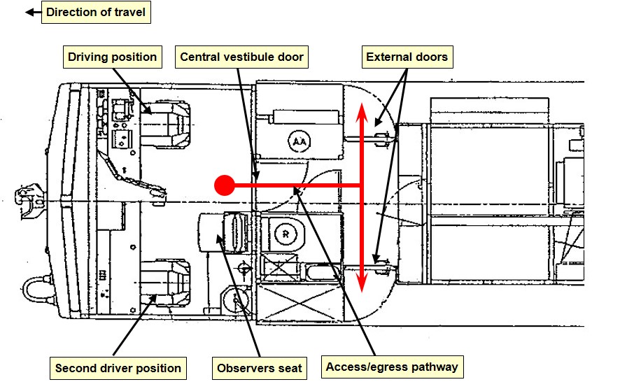
Diagram of 2800 class locomotive emergency egress path (in red) through centre vestibule and rear side doors. Source: Queensland Rail Annotated by ATSB.
Following the derailment on 27 December 2015, locomotive 2814 came to rest on the driver’s side, right side in direction of travel, in about 600 mm of muddy water. All crewmembers were thrown into the muddy water that had entered the cab (Figure 26). A crewmember located the emergency smash glass hammer and began to strike the front windshield of the locomotive.
Crewmembers struck the right side windshield (closest to the ground) about 24 times and the left side windshield (upper) about 35 times. The train crews’ attempts to smash the windscreen using the hammer were futile (Figure 27). The train crew tried using other items in the cab to smash through the windshields without success.
The windshields were laminated glass, used to prevent external objects from piercing the windshield and injuring the crew. The emergency smash glass hammer was completely ineffective on the laminated glass of the windshields. Furthermore, the wire tether connecting the hammer to the mount was not long enough to allow an effective swing. As the locomotive had rolled onto its side, the crew did not use the emergency hammer on the side windows; its effectiveness on the side windows of the locomotive was unknown.
Figure 26: Locomotive 2814 cab
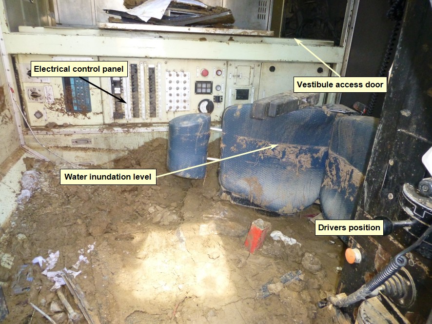
Image showing drivers side seating position and vestibule access door at the rear of the cab post derailment. Floodwaters and sediment entered the locomotive cab to a depth of 600 mm inundating communications and electrical systems. Debris in vestibule door was placed in vestibule during recovery operations. Source: ATSB
Aurizon advised that the emergency escape paths/arrangements to evacuate from a locomotive were part of the training delivered during trainee development. The effectiveness of this training for an escape from a situation where a locomotive had tipped was not evident.
Although the emergency escape paths from a 2800 class locomotive provided options, these options became less accessible with the locomotive on its side.
In the derailment of train 9T92, both identified escape paths necessitated the crew climbing on internal structures to facilitate egress. One of the crewmembers had sustained injuries, and required substantial assistance by other crew to facilitate their escape in climbing up through the cab and out of the side window (now on top).
For comparison, the newer Aurizon 4100 class locomotives, also constructed prior to the publishing of the RISSB Standard AS 7522, were fitted with removable windshields. During an emergency, train crew could readily remove the windshields and evacuate the cab at ground level, even with the locomotive tipped on its side. The provision of an additional emergency exit through the front of the locomotive was consistent with the RISSB Standard by having a supplemental escape path at the front of the compartment in addition to the routine entry and egress paths through the vestibule at the rear.
Figure 27: Damage to windscreens of locomotive 2814
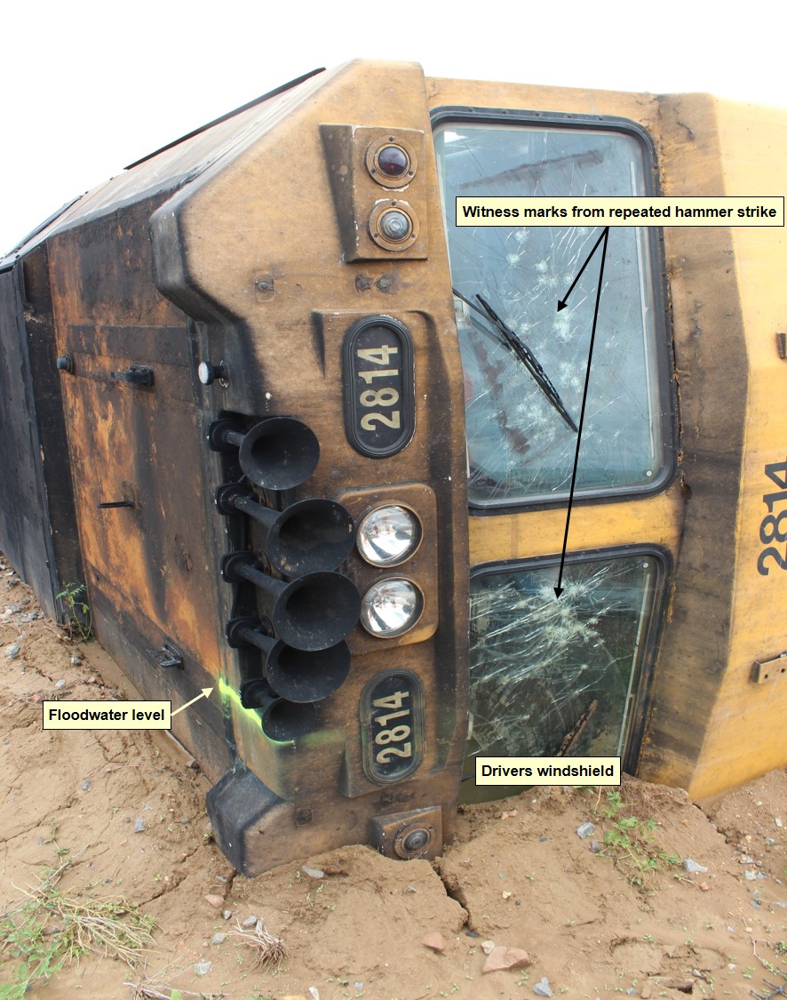
Image of leading locomotive 2814 in its final resting place and indicative water level. The image displays repeated attempt by train crew to smash out the windscreens with the emergency hammer. Source: Queensland Rail
When locomotive 2814 derailed, the ingress of water or loss of power affected all communication equipment (train radio, mobile phones, etc.) rendering it unserviceable. This meant that the train crew were initially unable to alert anyone about the incident.
The train crew knew the train was carrying dangerous goods. Their immediate concern was to evacuate the inundated locomotive cab, find a safe place, and communicate the details of the incident.
During evacuation, the train crew noticed vapour emanating from the wreckage (derailed tanker wagons). The train crew were not equipped with personal protective equipment (PPE) specific to the sulphuric acid product transported.
Train crews were however required to carry PPE breathing apparatus when attending the train in areas where loading or unloading operations occurred. The respective product handling companies provided the PPE apparatus for train crew to use within their facilities. There were no similar PPE requirements stipulated by Aurizon when transporting the product between facilities.
Following the incident, Aurizon introduced breathing apparatus on trains transporting acid. The arrangements to manage the control, training, issue, compliance, or maintenance of the equipment were to be finalised. Aurizon also commenced a review of emergency evacuation procedures, locomotive windscreens and secondary communication opportunities/options.
QR assessment of risk
Track drainage design
An upgrade of the Mount Isa rail corridor between Townsville and Mount Isa occurred circa 1960, using the standards and practices at that time. A hydrological study was conducted to assist in the design of bridges and culverts for the line at that time. The study was completed under time pressure and as a result, the assessment of the track provided ‘quick fix’ solutions to upgrade the railway line. Information kept by QR did not detail the hydrologic modelling or hydraulic assessment defining the designed flood immunity for the constructed track infrastructure.
Current QR standards (revised on 16 December 2015) did not specify the standard of service required of track infrastructure in relation to flooding. The standards required the QR Rail Infrastructure Manager to exercise ‘sound professional judgement’ in the management of risk. No records were available detailing the hydrologic modelling, hydraulic assessment or design criteria for the alterations to the drainage infrastructure at the location where train 9T92 derailed.
The RISSB published Australian Standard AS7637:2014 Hydrology and Hydraulics. The standard describes the hydrologic and hydraulic requirements (functions, performance, design constraints and risk attributes) for the design and assessment of railway infrastructure in relation to all forms of drainage and flood-prone areas.
The Standard provides a framework that promotes consistency and efficiency in design, construction, commissioning, maintenance, monitoring and decommissioning of track drainage and waterway crossings.
The Australian standard AS7637-2014 Hydrology and Hydraulicsstates:
Managing risks from flooding may include improving the flood immunity of railway infrastructure and surrounding areas, as well as reducing the impacts of flooding by minimising the railway's vulnerability and exposure to flooding.
Flood risk management should be addressed in a Flood Management Plan and include the following:
(a) Flood hazard identification
(b) Flood risk assessment
(c) Emergency response plan
(d) Flood management and mitigation
(e) Flood warning system
(f) Vulnerability assessment
(g) Identification of roles and responsibilities.
QR had undertaken work that incorporated several elements identified in the AS 7637 in undertaking improvement to the flood immunity of the rail infrastructure at the identified flood hotspot areas. However, flood hazard identification and flood risk assessment was not available for the majority of the Mount Isa railway to establish the flood immunity of the rail infrastructure, such as the culvert location where train 9T92 derailed.
Risk registers
The QR infrastructure hazard location register did not include all the locations identified by the QR Townsville Control centre as hotspots prone to flooding. Each business division controlled the records independently of the other.
On 31 January 2013, passenger train T842 collided with the station platform at Cleveland. The ATSB investigation into the occurrence identified a number of safety issues. One relevant safety issue was:
Despite numerous occurrences of slip-slide events in the years leading up to the accident at Cleveland, Queensland Rail’s risk management processes did not precipitate a broad, cross-divisional, consideration of solutions to the issue including an investigation of the factors relating to poor wheel/rail adhesion. [Safety issue]
This safety issue, although not directly related to this incident, highlighted deficiencies in organisational processes to identify hazards and disseminate them through the individual business divisions.
Queensland RaillAurizon procedures
Queensland Rail (QR) had developed and implemented operational rules and procedures for the management of flooding on their rail network. In this case, Aurizon was operating on the QR network. However, Aurizon is also an infrastructure manager and had similar operational rules and procedures for the management of flooding on their rail network.
These documents included:
- Queensland Rail – Queensland Network Rules and Procedures (MD-12-189, Ver. 2.1) 14 April 2014
- Queensland Rail – General Operational Safety Manual (MD-10-107, Ver. 2.4) 10 March 2014
- Queensland Rail – Townsville Regional Safety Committee Newsletter, Wet Weather Protocols
- Aurizon – Critical safety alert – Working rail traffic in flooded areas (CSA QR National 04-2014) 10 December 2010
- Aurizon – Community of Competence - Derailment education pack 21 September 2010
- Aurizon – Hazard and Risk Inventory - Driving Trains on Mainline [all crew configurations] (RIS.012, Ver. 3) (February 2011).
Each document outlined various requirements on staff when responding to an identified flood-affected area of the respective rail network. Table 1 highlights variances between the requirements in documents maintained by the rail infrastructure managers to define the particular conditions for reporting or level of water required to stop trains on their respective networks. Additional variances are evident when the train crew of one organisation is operating rolling stock on the other organisation’s rail network.
Table 1: Comparison of procedural actions
| Rule / procedure | Reporting | Stop trains |
| QR MD-12-189 (QR 2009 Reporting And Responding To A Condition Affecting The Network) | Conditions that can or do affect the network must be reported promptly…If there is any doubt about the safety of rail traffic…tell the NCO | If necessary prevent rail traffic from approaching and apply protection…The NCO must, as necessary, warn train crew and prevent rail traffic from approaching… |
| QR MD-12-189 (QR 3027 Operating Rail Traffic In Flood Affected Areas) | Nil specified (consequent to QR 2009) | If made aware of flood affected track NCO must stop trains |
| QR MD-10-107 (Module GS-1, Sect 1.3 Adverse Conditions Affecting Operations On The Network) | Where it is required to operate trains in adverse conditions, such as heavy rain...Train crew to advise the NCO | The NCO should consult to determine other factors that may impact on the running of rail traffic.Where information is available, the network control officer will advise if it is unsafe for rail traffic to travel |
| QR MD-10-107 (Module GS-1, Sect 1.9 Working Traffic Through Flooded Areas) | Nil specified (consequent to Module GS-1, Sect 1.3) | Until track has been checked and provided floodwaters were > 250mm (maximum depth for type of rolling stock) above top of rail. |
| QR Wet Weather Protocols | NCO to provide information to train crew:Weather report advice, when neededConditions that could stop traffic* Water levels rising.* Water entering the ballast* Severe localised storm | Conditions are uncertain.Weather monitors indicate a problemWater is in ballast.Report from the last train over the section that indicates a problemCyclone or other severe weather event |
| Aurizon Critical Safety Alert | Floodwaters on the track formation or near the ballast | If train crew cannot see formation and/or ballastSigns of washout or scouring |
| Aurizon community of Competence | Running water on or approaching ballast. | If train crew had concernsTrain crew not to drive through water |
| Aurizon Driving Trains on Mainline | Train control protocols. | Train control protocols. |
Neither the QR nor Aurizon documents provided unambiguous triggers/descriptors to quantify conditions that constituted a ‘flood affected track’ or to enable consistent identification and assessment or communication of a potential hazard from floodwaters that may affect the integrity of the track or safety of the train.
On 27 December 2015, the train crew were operating train 9T92 on the Mount Isa line, managed by QR. After stopping and assessing the floodwaters at Spellary Creek, the Aurizon train crew of train 9T92 proceeded, prior to notifying the conditions to the QR NCO.
The QR documents, MD-12-189 and MD-10-107 detailed the applicable network rules and operational procedures applied by train crew operating on the railway. The documents identified procedures[29] for the NCO if made aware of flood affected track and train crew (when necessary) to operate rolling stock through areas of ‘flood affected track’. The procedures specified the train speeds, after receipt of approval to proceed, for driving through the water. The allowable speed was dependent on the depth overtopping the track for type of rolling stock operated. The procedures contained no reference to what conditions defined a flood-affected area other that reference to where floodwaters had overtopped the track.
In this case, the train crew likely assessed the conditions as not meeting the trigger to stop the train at that point from proceeding or immediately report to the NCO. It is likely that if a clear trigger existed regarding floodwaters that have overtopped the track before receding, the train crew would have immediately reported or not have proceeded.
Neither document contained a clear definition of the flood conditions that constituted a hazard to the integrity of the track if water had not yet overtopped the track. Without an unambiguous definition of the conditions that are likely to affect the integrity of the track, including freeboard[30], reporting is reliant on individual assessment of the train crew or NCO.
The Aurizon documents also included trigger events for reporting floodwater. The triggers varied from those that the QR NCO was looking for to determine what action to take. Aurizon train crew training included both the Aurizon and relevant QR rules and procedures for crew operating on the Mount Isa line. Additionally, Aurizon train crews received training on the ‘do’s and don’ts’ when driving trains during a wet weather event. Aurizon also referred train crew to supplementary information contained in advice or alert notices issued from time to time.
The triggers included within the train crew training covering identifying hazards from wet weather were inconsistent between the Aurizon documents and the QR documents. Although Aurizon’s alert to their staff included information for network controllers, this was not applicable to the network controllers managing the QR network.
Furthermore, the document was marked to ‘remove from circulation: 10-12-11’. Aurizon advised that although it was marked for removal from circulation, it was still current and available from the Aurizon intranet for reference by the train crew. A critical safety alert stored within the intranet since 2011 has the potential to lose significance to train crew when removed from circulation, particularly given that subsequent documents did not reflect the critical content of the alert. Similarly, there is the potential that withdrawn critical alerts may not be included in training documentation. This increases the risk that personnel undertaking subsequent training may be unaware of the critical alert and its contents.
In summary, the QR NCO and Aurizon rail traffic crew relied on different triggers to determine action in response to conditions potentially affecting the network from a weather event. Train crew were likely assessing hazards based on a go-no go schema of water covering the track. Conversely, NCO was looking for information to predict conditions likely to affect the network.
The train crews operating on the network perform a key role in the timely identification of a condition affecting or likely to affect the network. This is particularly relevant for weather related events in remote areas where there is a sparse distribution of weather monitoring stations.
Rail infrastructure managers of a network and rolling stock operators conducting operations on a network need to ensure that train crew are provided with unambiguous guidance to identify a potential hazard to the rail infrastructure on the network.
Predictive information
The NCOs used various means to detect or monitor risks to the network. During a wet weather event, NCOs typically referred to information from the BoM website. The use of the BoM information, including the rain radar, assisted the NCOs to identify potential locations for flooding along the rail corridor. However, the information attainable from the publically available BoM rain radar images has limitations and may be misleading, especially when used in isolation.
The ATSB investigated several previous occurrences on other rail networks where ineffective weather prediction increased risk for rail operations. The investigations explored the use of specialist weather advice and warnings for predicting weather events.
Queensland Rail (QR) already source specialist advice on electrical storms that may affect the electrical rail network in southeast Queensland. However, provision of this type of advice at the Townsville Train Control Centre was not evident. Specialist weather advice and warnings may assist operational staff at Townsville to respond to potential hazards from weather events in the northern areas of Queensland.
__________
- Rolling stock where a change has been implemented that affects its compliance with the requirements in this standard.
- MD-10-189, QR 3027 Operating Rail Traffic in Flood Areas and MD-10-107 GS 1, 1.9 Working traffic through flooded areas.
- The difference in height between the calculated water surface elevation and the top, overt, crest of a structure, and provided for the purpose of ensuring a safety margin above the design water elevation.
From the evidence available, the following findings are made with respect to the derailment of train 9T92 that occurred about 20 km east of the Julia Creek, Queensland on 27 December 2015. These findings should not be read as apportioning blame or liability to any particular organisation or individual.
Safety issues, or system problems, are highlighted in bold to emphasise their importance. A safety issue is an event or condition that increases safety risk and (a) can reasonably be regarded as having the potential to adversely affect the safety of future operations, and (b) is a characteristic of an organisation or a system, rather than a characteristic of a specific individual, or characteristic of an operating environment at a specific point in time.
Contributing factors
- Scouring of the ballast and formation adjacent to the 617.190 km point by floodwater meant that the track could not support the weight of train 9T92 as it passed over the affected area. The resulting deformation in alignment of the track initiated the derailment.
- The Queensland Rail General Operational Safety Manual (MD-10-107) contained insufficient guidance for rail traffic crews to ensure the timely identification and management of a potential hazard (resulting from a weather event) that might affect the safe progress of the train.[Safety issue]
Other factors that increased risk
- The information kept by Queensland Rail about hydrological and hydraulic assessments undertaken on Great Northern Railway was inadequate to define the designed flood immunity of rail infrastructure.
- The Queensland Rail procedures provided insufficient guidance on the limitations of the weather information available on the Bureau of Meteorology website applicable to areas of the Great Northern Railway.
- The Queensland Rail network rules, procedures and safety manual provided insufficient guidance to identify the magnitude of the potential hazard from a weather event, or define the response when encountering water that had previously overtopped the track and receded or was pooled against the track formation or ballast.[Safety issue]
- The Aurizon emergency egress arrangements for rail crew from the 2800 class locomotive were not effective in all foreseeable circumstances.
- Appropriate Personal Protective Equipment was not available to the Aurizon train crew for an emergency involving the escape of vapour from a dangerous goods consignment (in this case, sulphuric acid).
- Wet Weather Protocols and Flood Hot Spot documents used by the Townsville Control Centre operational staff were not included within the Queensland Rail safety management system.
Other findings
- There were no anomalies identified with the train speed, handling, rolling stock condition, or operational performance preceding the derailment.
- Queensland Rail’s management of operations in response to the wet weather event was generally in accordance with the organisation’s existing policies and procedures.
- There were no anomalies identified with the construction of the Incitec Pivot GATX tanker wagons that contributed to the loss of product from the derailment of train 9T92.
Safety issues and actions
The safety issues identified during this investigation are listed in the Findings and Safety issues and actions sections of this report. The Australian Transport Safety Bureau (ATSB) expects that all safety issues identified by the investigation should be addressed by the relevant organisation(s). In addressing those issues, the ATSB prefers to encourage relevant organisation(s) to proactively initiate safety action, rather than to issue formal safety recommendations or safety advisory notices.
Depending on the level of risk of the safety issue, the extent of corrective action taken by the relevant organisation, or the desirability of directing a broad safety message to the [aviation, marine, rail - as applicable] industry, the ATSB may issue safety recommendations or safety advisory notices as part of the final report.
All of the directly involved parties were provided with a draft report and invited to provide submissions. As part of that process, each organisation was asked to communicate what safety actions, if any, they had carried out or were planning to carry out in relation to each safety issue relevant to their organisation.
The initial public version of these safety issues and actions are repeated separately on the ATSB website to facilitate monitoring by interested parties. Where relevant the safety issues and actions will be updated on the ATSB website as information comes to hand.
Hazard identification and assessment by rail traffic crew
The Queensland Rail General Operational Safety Manual (MD-10-107) contained insufficient guidance for rail traffic crews to ensure the timely identification and management of a potential hazard (resulting from a weather event) that might affect the safe progress of the train.
Rail safety Issue: RO-2015-028-SI-01
Rail safety Issue: RO-2015-028-SI-02
Sources of information
The sources of information during the investigation included the:
- Australia Eastern Railroad (Aurizon)
- Bureau of Meteorology
- Incitec Pivot
- Office of the national rail safety regulator
- Queensland Police Service
- Queensland Rail
- Queensland Department of Transport and Main Roads (Rail Regulation)
- Queensland Department of Transport and Main Roads
- Train crew of 9T92
References
- Aurizon Critical Safety Alert, Working Rail Traffic in Flooded Areas, CSA QR National 04-2010, dated 10-12-2010
- Aurizon Derailments – Education Pack, issue date 21 September 2012
- Aurizon Hazard and Risk Inventory – Driving Trans on Mainline (all crew configurations) RIS.012, version 3, 9 February 2011
- Aurizon Operating Plan for Sulphuric Acid (IPL) Version 1.0, 17 July 2015
- Australian Standard AS 1210 – 1997 Pressure vessels
- Australian Standard AS 3788 – 1990 Boilers and pressure vessels – In service inspection
- Australian Standard AS 7637:2014 – Hydrology and Hydraulics
- Bureau of Meteorology Monthly Weather Review - Australia December 2015 Product code IDCKGC17R1. Prepared on 9 February 2016, ISSN 1836-3067
- Bureau of Meteorology report – Derailment of train 9T92 near Julia Creek, QLD on 27 December 2015, Version 0.3 Draft, 19 May 2016
- Mount Isa Line Derailment Analysis 2008 – 2013, V2 25 August 2014, Transport and Main Roads
- Queensland Local Disaster Management Guidelines, The state of Queensland (Emergency Management Queensland, Department of Community Safety) - 2012
- Queensland Rail Civil Engineering Track Standard MD-10-575, version 3.2, dated 11 November 1994
- Queensland Rail Civil Engineering Structures Standard MD-10-586, version 3.0, dated 22 October 2015
- Queensland Rail Disaster Management Townsville Region Plan, MD-15-486, version 1.0, dated 9/12/2015
- Queensland Rail Major Avoidable Event – Risk Profile: CR1.2
- Queensland Rail Standard, General Operational Safety Manual, MD-10-107, version 2.4, dated 10/03/2014
- Queensland Rail Standard, Queensland Network Rules and Procedures, MD-12-189, version 2.1, dated 14/04/2014
- Queensland Rail Townsville Regional Safety Committee Newsletter, Wet Weather Protocols, Thursday 1 December 2011
- Queensland Transport Occurrence classification guideline one (OC-G1), Document No OC-G1 Version 1, 13 June 2008
- RISSB National Guideline Glossary of Rail Terminology, 3 December 2010
Submissions
Under Part 4, Division 2 (Investigation Reports), Section 26 of the Transport Safety Investigation Act 2003 (the Act), the Australian Transport Safety Bureau (ATSB) may provide a draft report, on a confidential basis, to any person whom the ATSB considers appropriate. Section 26 (1) (a) of the Act allows a person receiving a draft report to make submissions to the ATSB about the draft report.
A draft of this report was provided to:
- Australia Eastern Railroad (Aurizon)
- Bureau of Meteorology
- Incitec Pivot
- Queensland Police Service
- Queensland Rail
- Queensland Transport and Main Roads (Rail Regulation)
- Queensland Transport and Main Roads (Program Delivery and Operations)
- Witnesses and individuals
Submissions were received from Australia Eastern Railroad (Aurizon), Queensland Rail, Queensland Transport and Main Roads (Rail Regulation), Queensland Transport and Main Roads (Program Delivery and Operations) and witnesses and individuals. The submissions were reviewed and where considered appropriate, the text of the report was amended accordingly.
Appendix A – BoM Weather and Flood warnings issued during 26 and 27 December 2015
The following information details the weather warnings issued by the Bureau of Meteorology for the area around Julia Creek between 2053 on Saturday 26 and 0301 on Sunday 27 December 2015. The BoM provided the information to the ATSB within the report titled Derailment of train 9T92 near Julia Creek, Qld on 27 December 2015.
Severe Thunderstorm Warnings
IDQ20041
Bureau of Meteorology
Queensland Regional Office
TOP PRIORITY FOR IMMEDIATE BROADCAST
SEVERE THUNDERSTORM WARNING
for HEAVY RAINFALL
For people in parts of the Northwest Forecast District.
Issued at 8:53 pm Saturday, 26 December 2015.
Severe thunderstorms are likely to produce heavy rainfall that may lead to flash flooding in the warning area over the next several hours. Locations which may be affected include New May Downs and Mount Isa.
Queensland Fire and Emergency Services advises that people should:
- Never drive, walk or ride through flood waters. If it's flooded, forget it.
- Seek shelter, preferably indoors and never under trees.
- Avoid using the telephone during a thunderstorm.
- Beware of fallen trees and powerlines.
- For emergency assistance contact the SES on 132 500
The next warning is due to be issued by 11:55 pm.
Warnings are also available through TV and Radio broadcasts, the Bureau's website at www.bom.gov.au or call 1300 659 219. The Bureau and Queensland Fire and Emergency Services would appreciate warnings being broadcast regularly.

IDQ20041
Bureau of Meteorology
Queensland Regional Office
TOP PRIORITY FOR IMMEDIATE BROADCAST SEVERE THUNDERSTORM WARNING
for HEAVY RAINFALL
For people in parts of the Gulf Country, Northern Goldfields and Upper Flinders, Northwest and Central West Forecast Districts.
Issued at 10:18 pm Saturday, 26 December 2015.
Severe thunderstorms are likely to produce heavy rainfall that may lead to flash flooding in the warning area over the next several hours. Locations which may be affected include Cloncurry, Dajarra Hotel, Duchess Hotel, Selwyn and Mckinlay Roadhouse.
Queensland Fire and Emergency Services advises that people should:
- Never drive, walk or ride through flood waters. If it's flooded, forget it.
- Seek shelter, preferably indoors and never under trees.
- Avoid using the telephone during a thunderstorm.
- Beware of fallen trees and powerlines.
- For emergency assistance contact the SES on 132 500
The next warning is due to be issued by 1:20 am Sunday.
Warnings are also available through TV and Radio broadcasts, the Bureau's website at www.bom.gov.au or call 1300 659 219. The Bureau and Queensland Fire and Emergency Services would appreciate warnings being broadcast regularly.
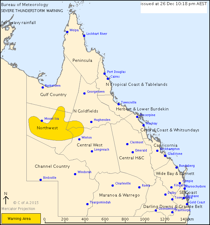
IDQ20041
Bureau of Meteorology
Queensland Regional Office
TOP PRIORITY FOR IMMEDIATE BROADCAST
CANCELLATION SEVERE THUNDERSTORM WARNING
Issued at 11:52 pm Saturday, 26 December 2015.
Severe thunderstorms are no longer occurring in QUEENSLAND.
The immediate threat of severe thunderstorms has passed, but the situation will continue to be monitored and further warnings will be issued if necessary.
Queensland Fire and Emergency Services advises that people should:
- Beware of fallen trees and powerlines.
- Never drive, walk or ride through flood waters. If it's flooded, forget it.
- For emergency assistance contact the SES on 132 500.
Warnings are also available through TV and Radio broadcasts, the Bureau's website at www.bom.gov.au or call 1300 659 219. The Bureau and Queensland Fire and Emergency Services would appreciate warnings being broadcast regularly.
IDQ20041
Bureau of Meteorology
Queensland Regional Office
TOP PRIORITY FOR IMMEDIATE BROADCAST SEVERE THUNDERSTORM WARNING
for HEAVY RAINFALL
For people in parts of the Northern Goldfields and Upper Flinders, Northwest and Central West Forecast Districts.
Issued at 1:30 am Sunday, 27 December 2015.
Severe thunderstorms are likely to produce heavy rainfall that may lead to flash flooding in the warning area over the next several hours. Locations which may be affected include Duchess Hotel, Selwyn and Mckinlay Roadhouse.
Queensland Fire and Emergency Services advises that people should:
- Never drive, walk or ride through flood waters. If it's flooded, forget it.
- Seek shelter, preferably indoors and never under trees.
- Avoid using the telephone during a thunderstorm.
- Beware of fallen trees and powerlines.
- For emergency assistance contact the SES on 132 500. The next warning is due to be issued by 4:30 am.
Warnings are also available through TV and Radio broadcasts, the Bureau's website at www.bom.gov.au or call 1300 659 219. The Bureau and Queensland Fire and Emergency Services would appreciate warnings being broadcast regularly.

IDQ20041
Bureau of Meteorology
Queensland Regional Office
TOP PRIORITY FOR IMMEDIATE BROADCAST SEVERE THUNDERSTORM WARNING
for HEAVY RAINFALL
For people in parts of the Northern Goldfields and Upper Flinders, Northwest and Central West Forecast Districts.
Issued at 3:01 am Sunday, 27 December 2015.
Severe thunderstorms are likely to produce heavy rainfall that may lead to flash flooding in the warning area over the next several hours. Locations which may be affected include Mckinlay Roadhouse.
Queensland Fire and Emergency Services advises that people should:
- Never drive, walk or ride through flood waters. If it's flooded, forget it.
- Seek shelter, preferably indoors and never under trees.
- Avoid using the telephone during a thunderstorm.
- Beware of fallen trees and powerlines.
- For emergency assistance contact the SES on 132 500. The next warning is due to be issued by 6:05 am.
Warnings are also available through TV and Radio broadcasts, the Bureau's website at www.bom.gov.au or call 1300 659 219. The Bureau and Queensland Fire and Emergency Services would appreciate warnings being broadcast regularly.
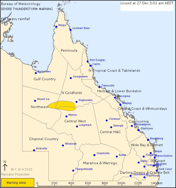
IDQ20041
Bureau of Meteorology
Queensland Regional Office
TOP PRIORITY FOR IMMEDIATE BROADCAST CANCELLATION SEVERE THUNDERSTORM WARNING
Issued at 5:05 am Sunday, 27 December 2015.
Severe thunderstorms are no longer occurring in QUEENSLAND.
The immediate threat of severe thunderstorms has passed, but the situation will continue to be monitored and further warnings will be issued if necessary.
Queensland Fire and Emergency Services advises that people should:
- Beware of fallen trees and powerlines.
- Never drive, walk or ride through flood waters. If it's flooded, forget it.
- For emergency assistance contact the SES on 132 500.
Warnings are also available through TV and Radio broadcasts, the Bureau's website at www.bom.gov.au or call 1300 659 219. The Bureau and Queensland Fire and Emergency Services would appreciate warnings being broadcast regularly.
Flood Watch
IDQ20890
Australian Government Bureau of Meteorology
Queensland
INITIAL FLOOD WATCH FOR THE GULF RIVERS CATCHMENTS
Issued at 12:57 pm EST on Sunday 27 December 2015 Issue Number: 1
Heavy rainfall associated with a low pressure system will affect the Gulf Rivers catchments over the next few days. The heaviest rainfall is expected to occur from Monday through to Wednesday.
Widespread daily rainfall totals of 50-100 mm are expected, with isolated falls of up to 150 mm possible with thunderstorms.
River level rises above the minor flood level are possible. Heavy rainfall may also lead to localised flash flooding.
Catchments at risk within the Flood Watch area include the Nicholson, Leichhardt, Flinders, Norman and Gilbert Rivers.
See www.bom.gov.au/qld/warnings to view the current flood warnings for Queensland.
This Flood Watch means that people living or working along rivers and creeks should monitor the latest weather forecasts and warnings and be ready to move to higher ground should flooding develop.
See www.bom.gov.au/qld/flood/brochures/flood_watch/ for further information about Flood Watch.
Remember: If it's flooded, forget it.
For flood emergency assistance contact the SES on 132 500
For life threatening emergencies, call Triple Zero (000) immediately Current emergency information is available at Disasters and alerts | Queensland Government (www.qld.gov.au)
Weather Forecast:
For the latest weather forecasts see: www.bom.gov.au/qld/forecasts
Next Issue:
The next Flood Watch is due to be issued by midday (12:00 pm) AEST on Monday 28th December 2015.
This advice is also available by dialling 1300 659 219 at a low call cost of 27.5 cents, more from mobile, public and satellite phones. Warning, rainfall and river information are available at www.bom.gov.au/qld/flood
Flood Warnings
IDQ20875
Australian Government Bureau of Meteorology
Queensland
INITIAL MINOR FLOOD WARNING FOR THE FLINDERS RIVER
Issued at 3:47 pm EST on Sunday 27 December 2015 by the Bureau of Meteorology, Brisbane.
Issue Number: 1
Minor flood levels are occurring in the Cloncurry River at Cloncurry.
Rainfall totals of 60-80 mm have been recorded in the Cloncurry River in the 24 hours to 9:00 am Sunday.
Further heavy rainfall is forecast over the next 3 days. Widespread daily rainfall totals of 50- 100 mm are expected with isolated heavier falls of up to 150 mm possible with thunderstorms.
FLINDERS RIVER:
Minor flood levels are being recorded on the Cloncurry River at Cloncurry. River level rises are also being recorded in the upper Flinders catchment at Richmond but are currently below the minor flood level.
Predicted River Heights/Flows: CLONCURRY RIVER at:
CLONCURRY: Minor flood levels will continue into Sunday evening. River levels may fall below the minor flood level overnight Sunday into Monday, however, with further heavy rainfall forecast, renewed river level rises and minor flood levels are expected again during Monday.
Remember: If it's flooded, forget it.
For flood emergency assistance contact the SES on 132 500
For life threatening emergencies, call Triple Zero (000) immediately Current emergency information is available at Disasters and alerts | Queensland Government (www.qld.gov.au)
Weather Forecast:
For the latest weather forecasts see: www.bom.gov.au/qld/forecasts
Next Issue:
The next warning is due to be issued by 9:00 pm AEST on Sunday 27th December 2015. Latest River Heights:
Flinders R at Richmond *3.26m rising 02:40 PM SUN 27/12/15
Cloncurry R at Cloncurry *3.33m rising 02:00 PM SUN 27/12/15
Julia Ck at Julia Ck *2.39m rising 12:47 PM SUN 27/12/15
Dugald R at Rail Crossing *2m rising 01:30 PM SUN 27/12/15
Williams R at Landsborough Hwy *2.24m falling 02:00 PM SUN 27/12/15
Flinders R at Etta Plains *0.06m steady 12:00 PM SUN 27/12/15
Cloncurry R at Canobie Auto *1.94m falling 12:00 PM SUN 27/12/15
Flinders R at Walkers Bend *0.74m steady 12:00 PM SUN 27/12/15
* auto station
Warnings and River Height Bulletins are available at www.bom.gov.au/qld/flood Flood Warnings are also available on telephone 1300 659 219 at a low call cost of 27.5 cents, more from mobile, public and satellite phones.
IDQ20875
Australian Government Bureau of Meteorology
Queensland
MINOR FLOOD WARNING FOR THE FLINDERS RIVER
Issued at 8:52 pm EST on Sunday 27 December 2015 by the Bureau of Meteorology, Brisbane.
Issue Number: 2
Minor flood levels are being recorded in the Cloncurry River at Cloncurry.
Rainfall totals of 60-80 mm have been recorded in the Cloncurry River catchment in the 24 hours to 9:00 am Sunday.
Further heavy rainfall is forecast over the next 3 days. Widespread daily rainfall totals of 50- 100 mm are expected with isolated heavier falls of up to 150 mm possible with thunderstorms.
FLINDERS RIVER:
Minor flood levels are starting to fall on the Cloncurry River at Cloncurry. River level rises are continuing in the upper Flinders catchment at Glendower Crossing and Richmond but are currently below the minor flood level.
Predicted River Heights/Flows: CLONCURRY RIVER at:
CLONCURRY: River levels will fall below the minor flood level overnight Sunday into Monday, however, with further heavy rainfall forecast, renewed river level rises and minor flood levels are expected again during Monday.
Remember: If it's flooded, forget it.
For flood emergency assistance contact the SES on 132 500
For life threatening emergencies, call Triple Zero (000) immediately
Current emergency information is available at Disasters and alerts | Queensland Government (www.qld.gov.au)
Weather Forecast:
For the latest weather forecasts see: www.bom.gov.au/qld/forecasts
Next Issue:
The next warning is due to be issued by 8:00 am AEST on Monday 28th December 2015.
Latest River Heights:
Flinders R at Richmond *3.75m rising 07:00 PM SUN 27/12/15
Cloncurry R at Cloncurry *3.27m falling 07:00 PM SUN 27/12/15
Julia Ck at Julia Ck *3.74m rising 07:30 PM SUN 27/12/15
Dugald R at Rail Crossing *1.62m falling 07:00 PM SUN 27/12/15
Williams R at Landsborough Hwy *2.05m falling 07:10 PM SUN 27/12/15
Flinders R at Etta Plains *0.19m rising 04:00 PM SUN 27/12/15
Cloncurry R at Canobie Auto *1.93m rising 04:00 PM SUN 27/12/15
Flinders R at Walkers Bend *0.75m steady 04:00 PM SUN 27/12/15
* auto station
Warnings and River Height Bulletins are available at www.bom.gov.au/qld/flood Flood Warnings are also available on telephone 1300 659 219 at a low call cost of 27.5 cents, more from mobile, public and satellite phones.
IDQ20875
Australian Government Bureau of Meteorology
Queensland
MINOR FLOOD WARNING FOR THE FLINDERS RIVER
Issued at 11:05 pm EST on Sunday 27 December 2015 by the Bureau of Meteorology, Brisbane.
Issue Number: 3
Minor flood levels are being recorded in the Cloncurry River at Cloncurry.
Rainfall totals of 60-80 mm have been recorded in the Cloncurry River catchment in the 24 hours to 9:00 am Sunday.
Further heavy rainfall is forecast over the next 3 days. Widespread daily rainfall totals of 50- 100 mm are expected with isolated heavier falls of up to 150 mm possible with thunderstorms.
FLINDERS RIVER:
Major flood levels are rising on Julia Creek at Julia Creek. Minor flood levels are starting to fall on the Cloncurry River at Cloncurry. River level rises are continuing in the upper Flinders catchment at Glendower Crossing and Richmond but are currently below the minor flood level.
Predicted River Heights/Flows: CLONCURRY RIVER at:
CLONCURRY: River levels will fall below the minor flood level overnight Sunday into Monday, however, with further heavy rainfall forecast, renewed river level rises and minor flood levels are expected again during Monday.
Remember: If it's flooded, forget it.
For flood emergency assistance contact the SES on 132 500
For life threatening emergencies, call Triple Zero (000) immediately Current emergency information is available at Disasters and alerts | Queensland Government (www.qld.gov.au)
Weather Forecast:
For the latest weather forecasts see: www.bom.gov.au/qld/forecasts
Next Issue:
The next warning is due to be issued by 8:00 am AEST on Monday 28th December 2015.
Latest River Heights:
Flinders R at Richmond *4.01m rising 10:00 PM SUN 27/12/15
Cloncurry R at Cloncurry *3.26m rising 10:00 PM SUN 27/12/15
Julia Ck at Julia Ck *4.51m rising 10:25 PM SUN 27/12/15
Dugald R at Rail Crossing *1.37m falling 09:00 PM SUN 27/12/15
Williams R at Landsborough Hwy *1.4m falling 10:28 PM SUN 27/12/15
Flinders R at Etta Plains *0.19m steady 08:00 PM SUN 27/12/15
Cloncurry R at Canobie Auto *2.24m rising 08:00 PM SUN 27/12/15
Flinders R at Walkers Bend *0.74m steady 08:00 PM SUN 27/12/15
* auto station
Warnings and River Height Bulletins are available at www.bom.gov.au/qld/flood Flood Warnings are also available on telephone 1300 659 219 at a low call cost of 27.5 cents, more from mobile, public and satellite phones.
Purpose of safety investigationsThe objective of a safety investigation is to enhance transport safety. This is done through:
It is not a function of the ATSB to apportion blame or provide a means for determining liability. At the same time, an investigation report must include factual material of sufficient weight to support the analysis and findings. At all times the ATSB endeavours to balance the use of material that could imply adverse comment with the need to properly explain what happened, and why, in a fair and unbiased manner. The ATSB does not investigate for the purpose of taking administrative, regulatory or criminal action. TerminologyAn explanation of terminology used in ATSB investigation reports is available here. This includes terms such as occurrence, contributing factor, other factor that increased risk, and safety issue. Publishing informationReleased in accordance with section 25 of the Transport Safety Investigation Act 2003 Published by: Australian Transport Safety Bureau © Commonwealth of Australia 2016
Ownership of intellectual property rights in this publication Unless otherwise noted, copyright (and any other intellectual property rights, if any) in this report publication is owned by the Commonwealth of Australia. Creative Commons licence With the exception of the Coat of Arms, ATSB logo, and photos and graphics in which a third party holds copyright, this publication is licensed under a Creative Commons Attribution 3.0 Australia licence. Creative Commons Attribution 3.0 Australia Licence is a standard form licence agreement that allows you to copy, distribute, transmit and adapt this publication provided that you attribute the work. The ATSB’s preference is that you attribute this publication (and any material sourced from it) using the following wording: Source: Australian Transport Safety Bureau Copyright in material obtained from other agencies, private individuals or organisations, belongs to those agencies, individuals or organisations. Where you wish to use their material, you will need to contact them directly. |


