Preliminary report released 29 May 2024
This preliminary report details factual information established in the investigation’s early evidence collection phase, and has been prepared to provide timely information to the industry and public. Preliminary reports contain no analysis or findings, which will be detailed in the investigation’s final report. The information contained in this preliminary report is released in accordance with section 25 of the Transport Safety Investigation Act 2003.
The occurrence
On 31 December 2023, at about 0902 local time, a truck configured as an A-double[1] road-train (truck) departed Yunta, South Australia on the Barrier Highway in the direction of Broken Hill, New South Wales.
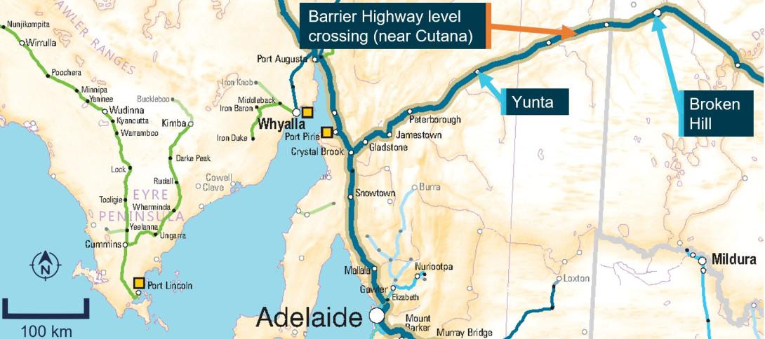
On the same day, following a crew change, the crew of Pacific National train 7SP5 reported to the network control officer that they had departed Broken Hill (towards Yunta) at 0919 (Figure 1).
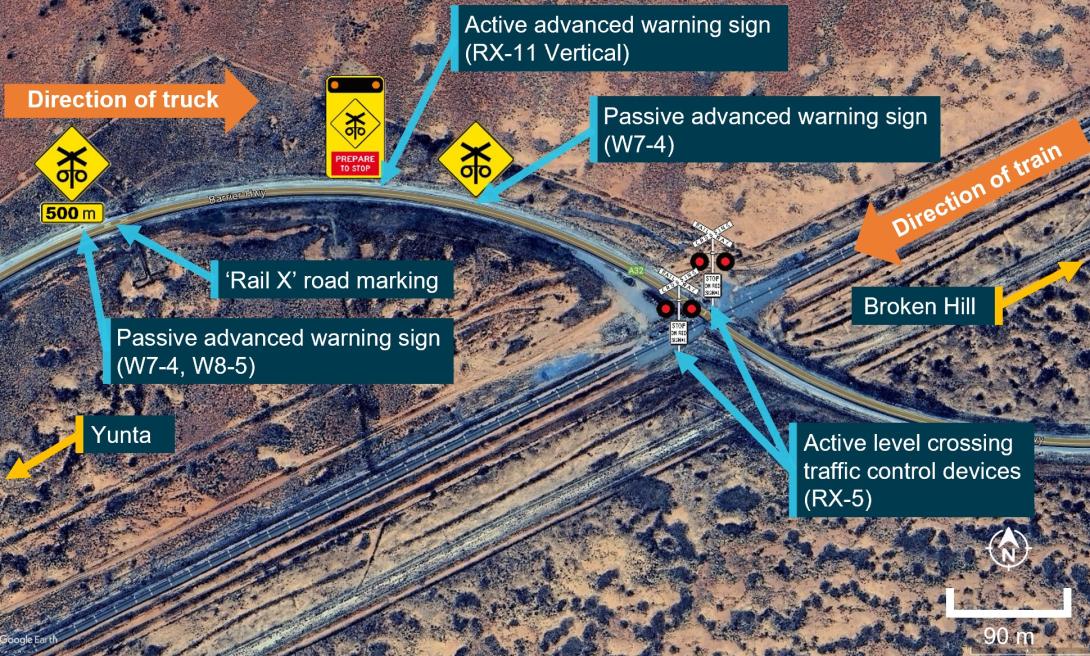
The road approach to the Barrier Highway level crossing near Cutana in the direction the truck was travelling consisted of a sweeping right curve. Passive road surface markings, as well as 2 passive[2] level crossing advanced warning signs, and an active[3] advanced warning sign provided advice to approaching road traffic of a crossing ahead.
The level crossing had active level crossing traffic control devices (flashing red light level crossing controls and bells). Further information about the advanced warning signs and traffic control devices is provided in the Level crossing section.
Figure 1: Map showing location of level crossing

Note: The image shows the Barrier Highway level crossing near Cutana, South Australia, in relation to Broken Hill, and Adelaide.
Source: ARA Railways of Australia Map 2014, annotated by the ATSB
As the train approached the level crossing, the active advanced warning sign and level crossing traffic control devices began operating. Recorded video from the truck as it approached the level crossing confirmed that the active advanced warning signs (flashing amber lights) and the active traffic control devices (flashing red lights) were operating. Recorded information from the locomotives confirmed that, during the approach to the level crossing, the headlight was on, the horn[4] was activated and an emergency brake application was made prior to the collision.
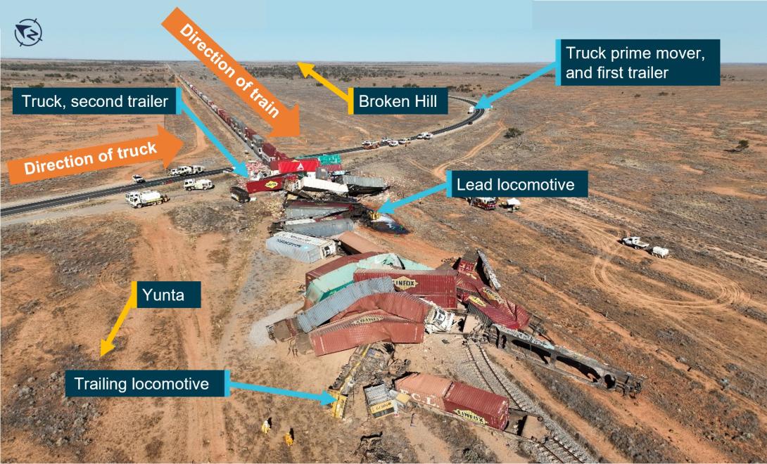
At approximately 1015 the truck, travelling at about 90 km/h, entered the activated level crossing into the path of Pacific National train 7SP5. The train, travelling at about 84 km/h, collided with the trailers of the truck, resulting in the derailment of both locomotives and 6 multi-platform 5-pack[5] wagons. The second trailer of the truck, both locomotives and several wagons were destroyed in the collision as well as substantial damage to the track and signal infrastructure, and active level crossing traffic controls (Figure 2). The train drivers received fatal injuries and no injuries were reported for the truck driver.
Figure 2: Overhead image of the accident site

Source: South Australia Police, annotated by the ATSB
At about 1030, the rail infrastructure manager (ARTC) received a number of calls from emergency services querying reports about a collision with a truck and derailment east of Yunta. The ARTC network control officer was unaware of a derailment or collision and commenced calling the crew of train 7SP5 that was known to be in that area.
The network control officer made multiple attempts to contact the crew via the train radio, before contacting Pacific National who then concurrently commenced trying to contact the crew via their personal mobile phones. At about 1124, a member of the public answered one of the train driver’s personal phones and confirmed to Pacific National that both drivers were fatally injured. Pacific National passed this information on to ARTC at about 1130, approximately the same time that the emergency services, despatched from Broken Hill, arrived at the scene.
Context
Truck information
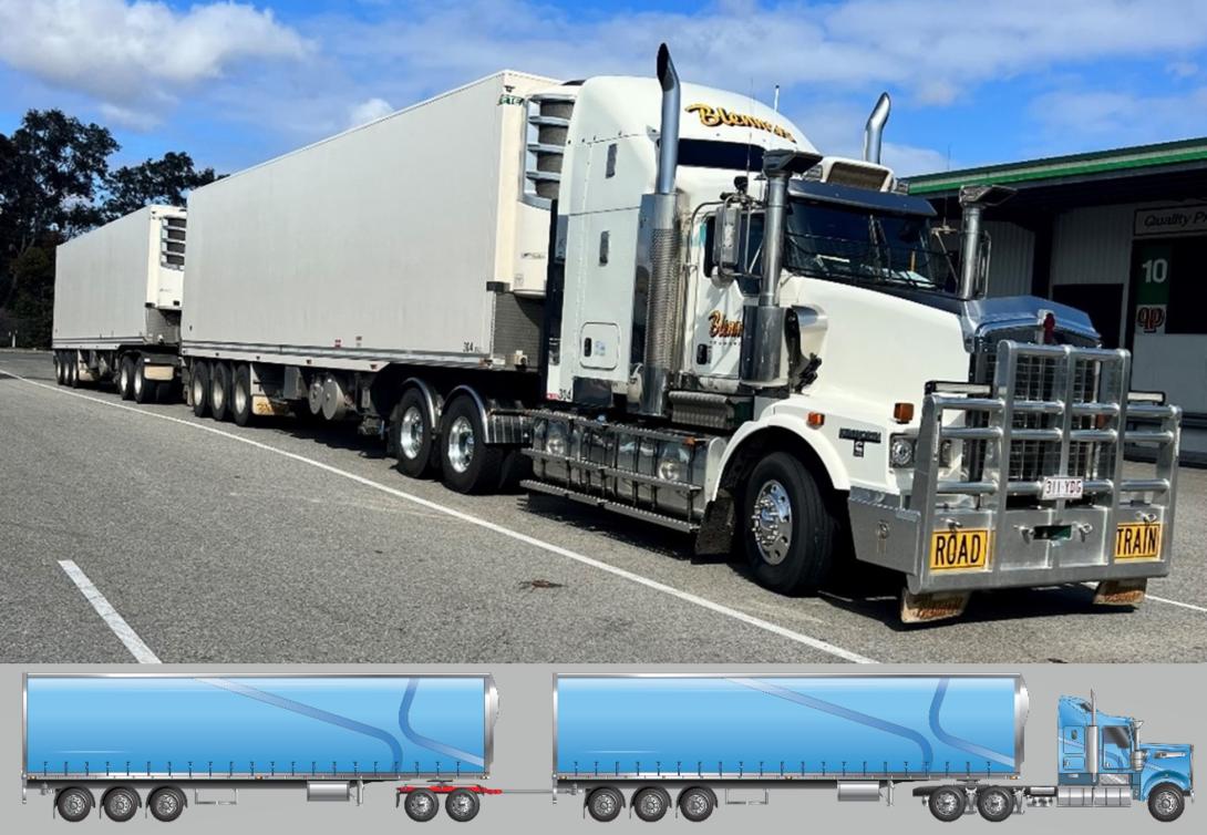
The truck was a 2018 Kenworth T659 prime mover, coupled to 2 FTE3A model refrigerated semi‑trailers in an A-double road train configuration (Figure 3). The combined unloaded weight of the truck and trailer was about 35 t. At the time of the collision, the truck was loaded with avocados and was on a return trip from Perth, Western Australia. The estimated weight of the loaded truck trailer combination was 78 t.
The truck driver was an experienced driver who was familiar with the route along the Barrier Highway and this level crossing.
Figure 3: Truck configuration prior to collision

Source: Main image, Blenners Transport; inset image National Heavy Vehicle Regulator, annotated by the ATSB
Train information
Train 7SP5 was a Pacific National intermodal freight service, crewed by 2 drivers that was scheduled to travel from Sydney, New South Wales to Perth, Western Australia. Train 7SP5 consisted of 2 locomotives, lead locomotive NR41 and trailing locomotive NR79, with 27 loaded multi-platformed wagons. The train was 1,771 m in length, with a total weight of 3,898 t.
The train crew involved in the collision had commenced their driving shift at Broken Hill about an hour before the collision.
Infrastructure information
Road
The Barrier Highway was a sealed road surface and key road transport corridor connecting South Australia and Western Australia to the far and central west of New South Wales. The road manager for the section of the highway, including this level crossing, was the South Australian Department of Infrastructure (DIT).
The Barrier Highway at the location of the level crossing is oriented in a north-east to south-west direction before curving right immediately prior to the level crossing. On the other side of the level crossing, the road returned to a north-east to south-west orientation (Figure 4). The maximum speed limit for road-trains was 90 km/h.
Rail
The rail corridor at this location forms part of the defined interstate rail network, connecting New South Wales to South Australia, Western Australia, and the Northern Territory. The rail infrastructure manager for this section of the rail network was the Australian Rail Track Corporation (ARTC).
The rail infrastructure at the level crossing was a single bi-directional standard gauge line. The line had tangent track[6] with minimal gradient (about 1 in 450). The maximum track speed at the level crossing was 115 km/h.
Level crossing
The level crossing was located on the Barrier Highway, about 114 km north-east of Yunta and 84 km south-west of Broken Hill at the 309.701 km mark (Figure 1).
The land adjacent to the Barrier Highway on the approach to the level crossing was sparsely vegetated with low-lying stubble and minimal trees. There was minimal road gradient, with the road being about the same height as the train line around the vicinity of the rail approach towards the level crossing. On the southern side of the track, the ground surface did fall below the height of the road and rail infrastructure.
The level crossing approaches were fitted with passive road markings, passive advanced warning signs and active advanced warning signs (Figure 4). The placement of these signs from the level crossing, in the direction the truck approached the crossing, was about:
- 500 m for the first passive advanced warning sign (sign type W7-4 and W8-5)
- 485 m for the ‘Rail X’ road marking
- 267 m for the active advanced warning sign (sign type RX-11 vertical)
- 193 m for the last advanced warning sign (sign type W7-4).
The road manager (DIT) was responsible for the road markings and signage, and the maintenance and operation of the advanced warning signs.
The level crossing was equipped with active level crossing traffic control devices (flashing red light level crossing controls and bells). This consisted of 2 RX-5 style active level crossing traffic control devices on either side of the track and road. The active level crossing traffic control devices were comprised of light-emitting diode type lights with hooded housings and target boards to enhance visibility and were focused to provide warning to each road approach. The rail infrastructure manager (ARTC) was responsible for the maintenance and operation of the active level crossing traffic control devices.
Figure 4: Aerial view of the level crossing approach and road alignment

Source: Google Earth, annotated by the ATSB
Further investigation
To date, the ATSB has:
- attended and completed site inspections
- interviewed directly involved parties
- undertaken preliminary analysis of a number of sources of recorded data, including from the locomotive, the truck and network control.
The investigation is continuing and will include:
- further analysis of the recorded data
- review and examination of similar occurrences
- analysis of the operation of the truck and train
- review and examination of safety interface agreements
- analysis of the locomotive human survivability aspects with respect to train crew injuries
- review of train emergency alerting and location systems
- examination of the road-rail interface infrastructure, design, and environment.
A final report will be released at the conclusion of the investigation. Should a critical safety issue be identified during the course of the investigation, the ATSB will immediately notify relevant parties so appropriate and timely safety action can be taken.
Purpose of safety investigationsThe objective of a safety investigation is to enhance transport safety. This is done through:
It is not a function of the ATSB to apportion blame or provide a means for determining liability. At the same time, an investigation report must include factual material of sufficient weight to support the analysis and findings. At all times the ATSB endeavours to balance the use of material that could imply adverse comment with the need to properly explain what happened, and why, in a fair and unbiased manner. The ATSB does not investigate for the purpose of taking administrative, regulatory or criminal action. TerminologyAn explanation of terminology used in ATSB investigation reports is available here. This includes terms such as occurrence, contributing factor, other factor that increased risk, and safety issue. Publishing informationReleased in accordance with section 25 of the Transport Safety Investigation Act 2003 Published by: Australian Transport Safety Bureau © Commonwealth of Australia 2024
Ownership of intellectual property rights in this publication Unless otherwise noted, copyright (and any other intellectual property rights, if any) in this report publication is owned by the Commonwealth of Australia. Creative Commons licence With the exception of the Coat of Arms, ATSB logo, and photos and graphics in which a third party holds copyright, this publication is licensed under a Creative Commons Attribution 3.0 Australia licence. Creative Commons Attribution 3.0 Australia Licence is a standard form licence agreement that allows you to copy, distribute, transmit and adapt this publication provided that you attribute the work. The ATSB’s preference is that you attribute this publication (and any material sourced from it) using the following wording: Source: Australian Transport Safety Bureau Copyright in material obtained from other agencies, private individuals or organisations, belongs to those agencies, individuals or organisations. Where you wish to use their material, you will need to contact them directly. |
[1] A-double means a heavy road vehicle combination not longer than 36.5 m consisting of a prime mover towing two trailers in which the first semi-trailer is connected to the prime mover by a roll coupled connection and the second trailer is a dog trailer. A-doubles are sometimes called double road trains.
[2] Passive: warning or control of the movement of vehicular or pedestrian traffic across a railway crossing by signs and devices, none of which are activated during the approach or passage of a train, and which rely on the road user including pedestrians detecting the approach or presence of a train by direct observation.
[3] Active: warning or control of the movement of vehicular or pedestrian traffic across a railway crossing by devices such as flashing signs/signals, gates or barriers, or a combination of these, where the device is activated prior to and during the passage of a train through the crossing.
[4] The operation of the locomotive horn in a NR class locomotive also commences operation of the oscillating ditch lights on the front of the locomotive intended for enhancing the visibility of the leading vehicle of a train from the perspective of a driver of a motor vehicle approaching a level crossing.
[5] 5-pack wagon: an articulated wagon comprising 5 platforms.
[6] A track segment without any curves.


