
Investigation summary
What happened
On 9 October 2024, VH-ZMW, a Beech Aircraft B200, was conducting an air transport flight with 6 persons on board, from Toowoomba to Normanton, Queensland. The aircraft departed and, approximately 30 minutes into the flight, entered a thunderstorm. The pilot diverted the aircraft to Roma, Queensland, where it was assessed by an engineer. The aircraft sustained minor damage, and the passengers and pilot were uninjured.
What the ATSB found
The ATSB found that although the pilot delayed the initial departure, reviewed the available weather information, and discussed their plan with more experienced colleagues, the aircraft entered a thunderstorm resulting in minor damage to the aircraft.
The ATSB also found that as the airborne weather radar had been incorrectly installed, its effectiveness at detecting cloud was reduced and was providing misleading information, which degraded the pilot's in-flight assessing and planning.
In addition, the pilot’s fuel planning using the company software included a fixed reserve that was less than the value detailed in the company’s exposition.
Finally, prior to departure the pilot informed the passengers of possible turbulence and kept the seatbelt sign on throughout the flight. This briefing and decision‑making likely contributed to the safety of the passengers when turbulence was experienced.
What has been done as a result
The operator rectified the incorrect installation of the weather radar. While the operator already provided weather radar theory training, it was not specific to the device installed on the aircraft. A Garmin training course is now provided to company pilots.
The flight planning software has also been reviewed to ensure the correct parameters are used as per the operator’s exposition.
Additionally, even though fatigue was not considered a safety factor, the operator has introduced a new fatigue reporting tool and monitoring system for rostering.
Safety message
This incident highlights how quickly weather conditions can change and, where possible, remaining visual can provide better identification of the weather. Using equipment such as airborne weather radar, can provide pilots with better situational awareness. However, the equipment is only useful if it is installed correctly, and the pilot has previously used and become knowledgeable with operating it before they’re required to use it to assist with navigating weather.
Areas of known weather should be avoided by 20 NM (37 km) and weather radar should not be used for penetrating areas of known weather. Instead, it should be used at longer range to plan around the precipitation returns.

The ATSB SafetyWatch highlights the broad safety concerns that come out of our investigation findings and from the occurrence data reported to us by industry.
One of the safety concerns is reducing the severity of injuries in accidents involving small aircraft. In this case, the briefed use of seatbelts assisted to reduce injuries when the aircraft encountered significant turbulence.
The investigation
| Decisions regarding the scope of an investigation are based on many factors, including the level of safety benefit likely to be obtained from an investigation and the associated resources required. For this occurrence, a limited-scope investigation was conducted in order to produce a short investigation report, and allow for greater industry awareness of findings that affect safety and potential learning opportunities. |
The occurrence
On 9 October 2024, a Beechcraft B200, registered VH-ZMW and operated by Austrek Aviation, was being prepared for a passenger transport flight with a pilot and 5 passengers from Toowoomba Airport to Normanton Airport, Queensland. At 1138 local time, the pilot submitted a flight plan to air traffic services for a direct route to Normanton (route A) (Figure 1), intending to depart at 1600.
During the pilot’s preparations, they identified that thunderstorm activity was likely along the intended flight path. Consequently, they reported accessing multiple weather forecasts and observations via their electronic flight bag (EFB), which was running a flight planning application. Additionally, they used the Bureau of Meteorology weather radar to obtain an indication of likely thunderstorm activity in the area. The pilot also reported discussing the weather with their more experienced colleagues. At 1517, they revised the flight plan to route B, to overfly Roma Airport and then to Normanton, which was assessed as a more suitable route around the thunderstorm activity.
Figure 1: Planned flight routes
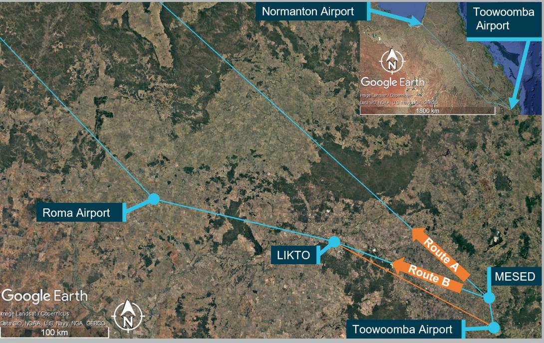
Source: Flight route submission provided by AirServices Australia, recreated and annotated by the ATSB overlaid on Google Earth
The pilot delayed departure due to a passing thunderstorm in the vicinity of Toowoomba. The pilot advised that prior to departure at 1620, they provided a briefing to the passengers, which included the possibility of encountering turbulence. Additionally, they kept the seatbelt sign on throughout the flight.
At 1624, the pilot reported to air traffic control (ATC) that they were taxiing for departure at Toowoomba. The controller advised that the pilot of another aircraft, approximately 20 NM (37 km) north‑west of Toowoomba, was currently deviating around multiple cloud build-ups[1] and asked what their intentions on departure were concerning the deteriorating weather in the area. The pilot opted to further revise their flight plan at this time and requested to fly directly to LIKTO waypoint[2] (Figure 1) rather than tracking north to the MESED waypoint as planned. Additionally, they advised that they would initially level at an altitude of 4,000 ft to remain clear of cloud until they could climb without entering it. On departure, the pilot estimated they would reach LIKTO at 1654.
At 1634, approximately 20 NM (37 km) north-west of Toowoomba, passing 10,900 ft on climb and clear of cloud, the pilot requested and received clearance to deviate 10 NM (18.5 km) right and left of the flight plan track to avoid cloud. They then turned onto a more northerly heading (Figure 2). The pilot later reported that they were able to maintain visual conditions up to the intended cruise level of FL 240.[3] Reaching FL 240 at 1645, the pilot observed a return on the weather radar to the right of the aircraft’s intended flight path, which they associated with a thunderstorm cell. Consequently, they deviated to the left toward the Toowoomba to LIKTO direct flight track. At this time another Beechcraft B200 departed Dalby Airport and climbed to an altitude of 4,000 ft, tracking for Roma Airport. This aircraft also reported an expected LIKTO arrival of 1654.
Figure 2: VH-ZMW actual flight track
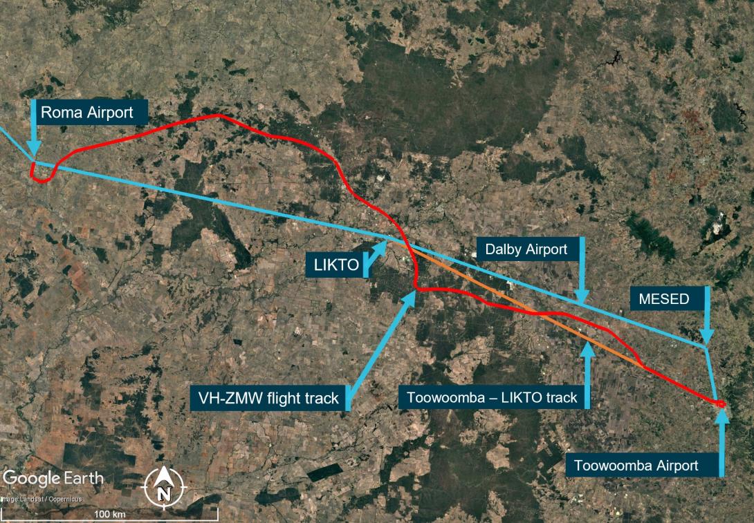
Source: Google Earth, annotated by the ATSB
Expecting that FL 260 would provide smoother conditions for the passengers, the pilot obtained ATC approval to climb. At approximately 1648, as they captured the new altitude, they entered what the pilot later described as ‘wispy cloud’, which the sun could be seen through.
With the aircraft operating at 150 kt indicated airspeed, the pilot noted that the outside air temperature at this time was −23°C and that the aircraft had begun to accumulate ice (see the section titled Icing). With the ice vanes for the air inlet on the engine cowl open (see the section titled Anti-Icing and de-icing equipment), the aircraft was operating near its altitude limit. As the pilot did not feel comfortable attempting to climb higher to exit the icing conditions, they instead requested to descend.
At about this time, the turbulence increased and the autopilot disconnected showing multiple failure annunciations. In response, the pilot manually flew the aircraft. They also attempted to adjust the weather radar to find the best route. However, due to the turbulence, they had difficulties adjusting the settings using the equipment’s touch screen.
At 1654 on descent and passing through approximately 18,500 ft, and still experiencing turbulence, the pilot of VH-ZMW contacted the pilot of the other Beechcraft B200, who had deviated to the north of LIKTO due to the weather in that area. Based on the discussion with that pilot, the pilot of VH-ZMW elected to track north. At 1656, the pilot of VH-ZMW contacted ATC and obtained a clearance to divert to Roma Airport to land and assess if they could continue to Normanton safely. They then tracked toward the other B200 location, which they observed on their traffic display.
The pilot later reported that between entering cloud at FL 260 and becoming visual at approximately 1705 at 4,000 ft they encountered turbulence, updrafts, downdrafts, icing, and observed lightning flashes. They also stated that they remained in control of the aircraft at all times.
At 1735, after landing at Roma Airport, the pilot endorsed the maintenance release with a possible lightning strike during a severe weather event. The subsequent engineering inspection did not identify any lightning strike damage however, there was minor damage observed to the leading edges of the aircraft’s wings and radome.[4] There were no injuries to the pilot or passengers.
Context
Pilot
The pilot held a commercial pilot licence (aeroplane) and a valid class 1 aviation medical certificate. They had completed an instrument proficiency check in a multi-engine aircraft and held the required design feature endorsements for the B200 aircraft. They had also completed an operator proficiency check flight on 23 September 2024.
The pilot had a total flight experience of 1,691.3 hours, of which 609.8 were on B200 type aircraft. The pilot had also accrued 190.3 hours of instrument flight experience and had completed a theory course in weather radar principles and operations on 8 August 2023.
Prior to the incident, they reported having 9.5 hours of sleep in the previous 24 hours and described feeling fully alert and wide awake.
Aircraft
VH-ZMW was a Beech Aircraft Corporation B200, manufactured in the United States in 1993 and issued serial number BB1460. It was registered in Australia on 9 June 2010 and registered with the operator on 9 October 2019. The aircraft could be operated by a single qualified pilot and was powered by 2 Pratt & Whitney PT6A-42 turbine engines driving 4‑blade Hartzell propellers.
Weather radar
The aircraft was equipped with an airborne weather radar capable of detecting and displaying areas of precipitation along the intended flight path. The device fitted to VH-ZMW had a 12-inch antenna, allowing a maximum weather avoidance range of 320 NM (593 km).
A weather radar detects moisture by sending out a microwave pulse beam that is reflected by moisture such as precipitation, and solid objects such as terrain. The return beam is captured by the weather radar antenna and presented to the pilot. As the initial radar beam leaves the aircraft, it expands the further it is from the aircraft (Figure 3).
Figure 3: Radar beam expansion
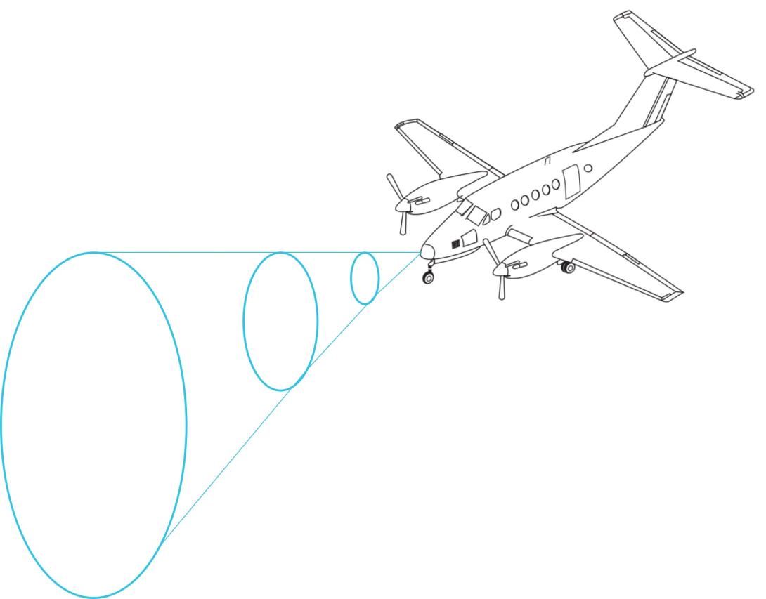
Source: Aircraft image from FlightSafety International–Super King Air 200/B200 pilot training manual 2002
The reflectivity of precipitation is dependent on the type of precipitation, which itself is affected by the outside air temperature (Figure 4). Lower air temperatures, where the precipitation has not yet frozen, results in good reflectivity and useful information presented to the pilot. However, frozen materials are less reflective and can be misrepresented or undetected. The weather radar training course stated that the least reflective areas occur below −20°C.
Figure 4: Reflectivity of precipitation types
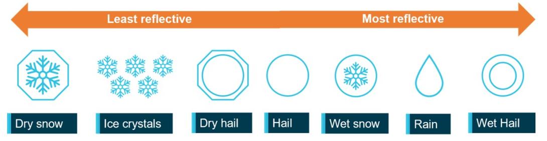
ATSB’s recreation of a similar image from the weather radar training video. Source: ATSB.
As the temperature of precipitation within a cloud decreases with altitude, the proportion of liquid water in the atmosphere will also decrease. That will generally reduce the reflectivity within the cloud. This means that a thunderstorm does not have the same reflectivity over its altitude range with the lower/middle altitudes of the cloud having much better visibility to weather radar.
The weather radar automatically pans left and right multiple times per minute to continually refresh the information provided to the pilot. The pilot can adjust the beam position by tilting the antenna up or down, with the maximum tilt angle of 15°, both up and down. If the radar beam is tilted too low, it can return terrain which can be misinterpreted as weather, this is known as ground clutter. To reduce ground clutter, the manufacturer advised the best practise is to set the tilt angle so ground returns are visible, then slowly tilt the radar up until the ground clutter is minimised.
Over-scanning occurs when the weather radar tilt angle is set too high, providing an inaccurate radar return (Figure 5).
Figure 5: Over-scanning
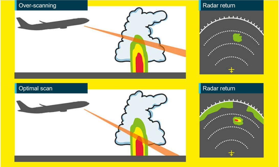
Source: Optimum use of weather radar, Safety first | July 2016 - Airbus S.A.S, annotated by the ATSB
When the pilot in command was asked about their technique for determining the best tilt angle, they described a similar method. They could not recall the exact tilt setting used on the day however, stated that they believed it was set at a 1° up tilt.
If the radar detects a return, it is displayed to the pilot in different colours, dependent on the intensity of the return (Figure 6).
Figure 6: Garmin GTN 700 series weather radar
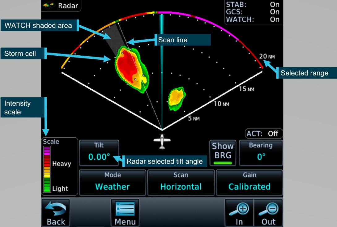
Source: Garmin GTN700 series manual, annotated by the ATSB
The weather radar has multiple options and settings to assist the pilot under different circumstances. The pilot reported that during the occurrence flight the range was set to 80–100 NM (148–185 km) and the following settings were used:
Table 1: Weather radar settings
| Radar optional setting | Active (ON/OFF) | Description |
| Altitude compensation tilt | ON | Automatically adjusts the tilt during climb and descent to keep centre of beam at same altitude (75% of selected range). The manufacturer recommend turning this setting off once reaching desired altitude. |
| WATCH | (default position is ON and pilot did not recall changing this setting) | Weather attenuated colour highlight (WATCH), highlights areas that are likely associated with radar shadow.[5] |
| Weather messages | ON | Provides alerts when presence of heavy precipitation beyond the currently displayed range and 80 to 320 NM from aircraft present position. Messages appear when the detected weather is within 10° of current heading. |
| Antenna stabilisation | ON | Corrects for pitch and roll changes, it keeps radar beam relative to horizon as aircraft attitude changes. |
The pilot’s guide stated the following:
The GWX weather radar should be used to avoid severe weather, not for penetrating severe weather. The decision to fly into an area of radar targets depends on target intensity, spacing between targets, aircraft capabilities, and pilot experience.
The weather radar training video stated that intense returns should be avoided by at least 20 NM (37 km).
The aircraft flight manual made the following statement regarding the use of weather radar:
Airborne weather avoidance radar is, as its name implies, for avoiding severe weather – not for penetrating it… Thunderstorms build and dissipate rapidly. Therefore, do not attempt to plan a course between echoes[6]…Remember that while hail always gives a radar echo, it may fall several miles from the nearest visible cloud and hazardous turbulence may extend to as much as 20 miles from the echo edge, avoid intense or extreme level echoes by at least 20 miles; that is, such echoes should be separated by at least 40 miles before you fly between them…
The operator’s exposition provided similar guidance to company pilots:
To minimise the risk of exceeding aircraft structural limitations due to thunderstorm turbulence,
the pilot in command should:
- ensure the aircraft does not take-off when thunderstorms are active within 10 NM of the aerodrome
- avoid thunderstorms enroute by diverting by a minimum of 10 NM upwind or 20 NM downwind
- the pilot in command must either hold or divert to an alternate aerodrome if a thunderstorm is within 20 NM of the destination aerodrome.
Forecast and reported areas of turbulence should be avoided whenever possible.
Weather radar installation
The operator advised that, as part of an aircraft upgrade, the weather radar was installed approximately 3 weeks prior to the occurrence. During the installation, it was inadvertently mounted into position offset from the lateral aircraft axis by approximately 1.9° right side low, rather than level (Figure 7).
Figure 7: Installation of the weather radar on VH-ZMW
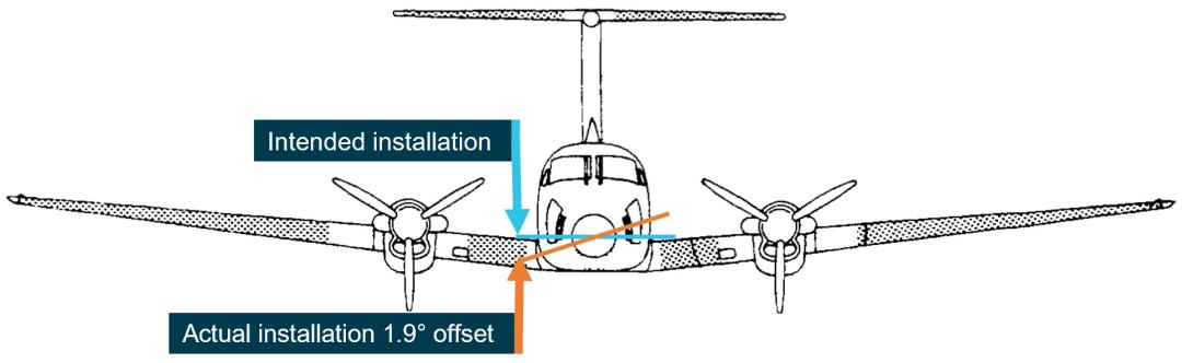
Source: VH-ZMW flight manual, annotated by the ATSB
This meant that, with the aircraft level, when the radar panned to the maximum left position, it was tilted up 1.9° and at the maximum right position, it was tilted down 1.9°. This resulted in ground clutter appearing on the right side of the radar when the left side was clear (Figure 8).
Figure 8: Weather radar ground clutter on VH-ZMW
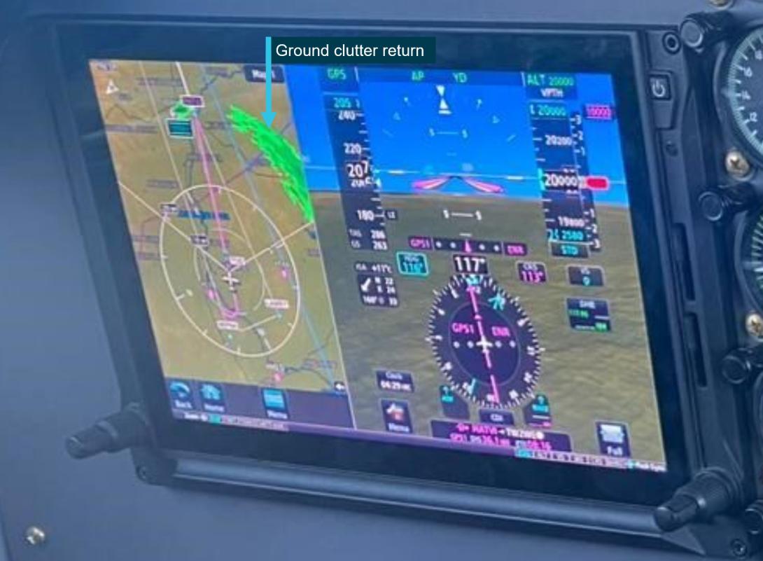
Source: Operator, annotated by the ATSB
Effect on the weather radar returns
Using the return from 10 NM (18.5 km) in front of the aircraft as an example, for a correct installation, the beam scanned a vertical range of approximately 8,300 ft. Therefore, if the tilt was 0° approximately 4,150 ft would be scanned below the aircraft and 4,150 ft would be scanned above the aircraft.
Based on the pilot’s recollection that the tilt angle was set at 1° up tilt, the following would be true at approximately 10 NM (18.5 km) from the aircraft’s position at FL 260:
Table 2: Minimum and maximum radar scan altitudes
| Aircraft altitude = FL 260 | Left scan 1.9° up from centre | Centre scan 1° above aircraft attitude | right scan right 1.9° below centre |
| Maximum altitude scanned | FL 330 | FL 310 | FL 290 |
| Minimum altitude scanned | FL 250 | FL 230 | FL 210 |
The table shows approximate values for an aircraft at FL 260, a 12-inch antenna, the radar set at a 1° up tilt and does not consider the curvature of the earth.
Autopilot
The aircraft was equipped with an autopilot that could manipulate the aircraft in pitch, roll, and yaw. The autopilot maintained lateral and vertical navigation based on the pilot’s mode selection.
The autopilot could be disconnected by pressing the autopilot ‘AP’ button on the device or by pressing the ’AP DISC / TRIM INT’ on the control yoke. Additionally, the manufacturer’s pilot’s guide stated:
Automatic disengagement may occur due to a failure within the … system, loss of both GPS and air data inputs, strong turbulence, or exceeding the engagement attitude limits.
Anti-icing and de-icing equipment
The aircraft was capable of flying into known icing conditions and was equipped with multiple anti‑icing[7] and de-icing[8] devices. The aircraft limitations required a minimum airspeed for sustained flight in icing conditions of 140 kt.
There was a pitot tube located on each side of the aircraft nose, and they were both equipped with individually‑selectable heating elements. The heated surface prevented ice from building up and blocking the pitot tube. Additionally, the stall warning vane was equipped with a heating element.
The propeller blades were equipped with electrically‑heated de-ice boots that loosened the attachment point of any ice build-up along the propeller blade. The ice was then detached due to forces associated with the rotating propeller. In the ‘AUTO’ position all electrical heating was provided to one propeller for 90 seconds and then cycled to the other propeller for 90 seconds.
De-ice boots were located on the leading edge of the wings and horizontal stabiliser. They were pneumatically inflated by bleed air[9] from the engines. The selector switch was spring loaded to the OFF position and could be selected to either single or manual. With single selected, the distributor valve opened to inflate the wing boots for approximately 6 seconds, it then deflated the wing boots and inflated the horizontal stabiliser boots for approximately 4 seconds, this completed the cycle. With manual mode selected, all boots inflated simultaneously and remained inflated until the switch was released.
There were 2 levels of windshield heat – normal and high. When normal mode was used, heat was applied to the majority of the windshield area. When high was selected, a higher level of heat was applied to a smaller area of the windshield.
Ice vanes in the air inlet of the engine cowl were required to be extended for operations in ambient temperatures of 5°C and below, when flight free of visible moisture could not be assured. When the ice vanes were extended, it introduced a sharp turn in the engine inlet air resulting in any moisture or frozen materials continuing undeflected, due to their momentum, and being discharged overboard. This reduced the amount of moisture entering the engine. When the ice vanes were in their extended position, the aircraft’s engine performance was reduced.
The pilot reported using the available anti-icing and de-icing equipment during the flight due to the accumulation of ice, which was observed to be building rapidly.
Turbulence
The aircraft flight manual specified a turbulence penetration speed of 170 kt. The flight manual also included the following caution for turbulent air penetration:
For turbulent air penetration, use an airspeed of 170 knots. Avoid over-action on power levers. Turn off autopilot altitude hold. Keep wings level, maintain attitude and avoid use of trim. Do not chase airspeed or altitude. Penetration should be at an altitude which provides adequate manoeuvring margins when severe turbulence is encountered.
Weather
Graphical area forecast
At 1417, a graphical area forecast (GAF) was issued for the south Queensland area. It was valid between 1500 and 2300, which included the planned and actual departure time. The GAF predicted occasional[10] cumulonimbus cloud (CB) from 4,000 ft extending above 10,000 ft. It also stated that CB implied severe icing and severe turbulence.
Icing
Ice can accumulate at temperatures below 0°C in visible moisture such as cloud and rain. According to the Bureau of Meteorology, the highest risk of ice accumulation is between 0°C and −15°C. However, ice can accumulate at temperatures as low as −40°C. The Bureau of Meteorology’s–Hazardous Weather Phenomena Airframe Icing stated:
The rate of ice accumulation is directly proportional to the amount of supercooled liquid water present. In clouds, the worst-case scenario is most likely to occur in towering cumulus and cumulonimbus because of their vertical extent, the abundant supply of moisture and the large droplet size found in them.
Severity classification
The Bureau of Meteorology classified icing into different severities, depending on the rate at which it accumulated:
- Trace is used when the rate of accumulation is slightly greater than rate of sublimation (the process of ice changing directly to vapour, bypassing the liquid phase).
- Light means the rate of accumulation may create a problem if flight is prolonged in the environment (i.e more than one hour). Occasional use of de-icing/anti-icing equipment is used.
- Moderate means the rate of accumulation is such that even short encounters become potentially hazardous, and use of de-icing/anti-icing equipment or diversion is necessary.
- Severe means the rate of accumulation is such that de-icing/anti-icing equipment fails to reduce or control the hazard, and thus an immediate diversion is necessary.
The Bureau of Meteorology classified turbulence intensity into categories dependent on perceived effect on the aircraft and occupants:
- Light is associated with momentary slight erratic changes in attitude and/or altitude. Rhythmic bumpiness. Airspeed fluctuations of 5–14 kt. G–loading of 0.15 to 0.49.
- Moderate is associated with appreciable changes in attitude and/or altitude. Pilot remains in control at all times. Rapid bumps or jolts. Airspeed fluctuations of 15–24 kt. G-loading of 0.50 to 0.99.
- Severe is associated with large abrupt changes in attitude and/or altitude. Momentary loss of control. Airspeed fluctuations greater than 25 kt. G-loading of 1.00 to 1.99.
- Extreme is associated with a very difficult to control aircraft. May cause structural damage. Airspeed fluctuations of greater than 25 kt. G-loading of greater than 2.00.
SIGMET
SIGMET[11] E01 was issued at 1416 and was valid between 1416 and 1630. It identified frequent[12] thunderstorms with hail. The top of the storms was stated as FL 450 and the storms were moving east-north‑east at 15 kt. SIGMET E01 covered the area west of Toowoomba Airport and the intended flight path went through the affected area (Figure 9).
Figure 9: SIGMET area
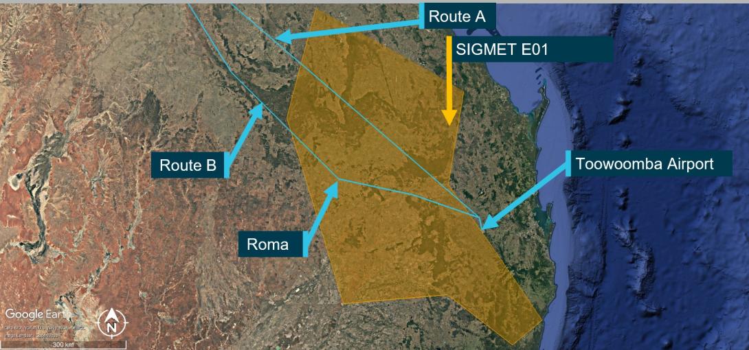
Source: Bureau of Meteorology provided SIGMET E01, ATSB annotated and re-created the SIGMET co-ordinates on Google Earth.
The SIGMET validity period for thunderstorm activity was no longer than 4 hours or the time specified. SIGMET E01 was valid for 2 hours and 14 minutes. The Bureau of Meteorology stated that the shorter validity period was an indication that the forecast weather phenomena was expected to have ceased by the end time stated. The pilot obtained and reviewed this SIGMET, which was available prior to their departure.
A follow-up SIGMET was issued at 1641, 10 minutes after the aircraft became airborne. It also identified frequent thunderstorms with hail in the area. Air traffic control provided the new SIGMET information to the pilot at 1653 after the aircraft had already entered significant weather.
Ground‑based weather radar
The Bureau of Meteorology provided the ATSB with ground-based weather radar images at different intervals throughout the flight. The ground-based weather radar available to the pilot prior to departure, showed that, apart from the storm activity in the vicinity of Toowoomba (that the pilot delayed the departure for), moderate level precipitation could be avoided by 20 NM (37 km) along the planned departure route (Figure 10).
Figure 10: 1600 Ground‑based weather radar
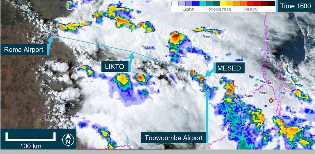
The image shows the route B flight path at 1600 which was the planned departure time. It is a combination of satellite and weather radar. Source: The Bureau of Meteorology provided weather radar and satellite image, ATSB overlaid on Google Earth and annotated.
Flight data
The ATSB obtained flight data information from the aircraft’s on-board recorder, the pilot’s EFB, and third‑party ADS-B recorded information. The ATSB used this data to determine the aircraft’s position, altitude, and speed at different times throughout the flight. This data was overlaid on the weather radar information provided by the Bureau of Meteorology (Figure 11). At 1630, there was less than 20 NM between intense weather returns. However, this was after the aircraft had departed.
Figure 11: Ground - Based weather radar at 1630 and 1700
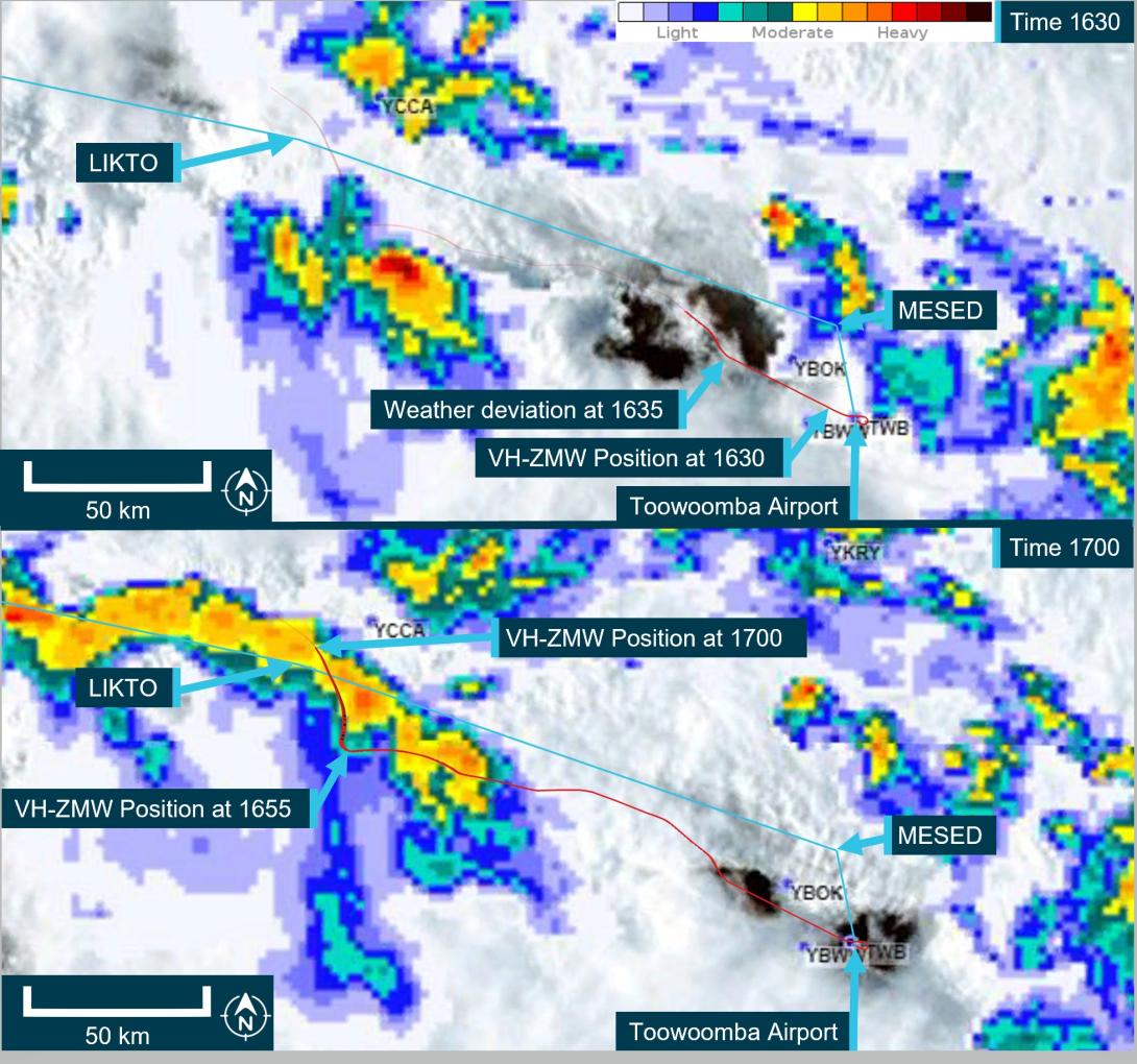
The image shows the route B flight path in blue with the actual aircraft flight path in red. It is a combination of satellite and weather radar. Source: The Bureau of Meteorology provided weather radar and satellite image, ATSB overlaid on Google Earth and annotated. Flight data provided by ADS-B exchange.
Flight planning
Flight route
The En Route Supplement Australia (ERSA) outlined the flight planning requirements for flights departing from Toowoomba Airport. It stated that when departing west, flights should plan via the MESED waypoint then to LIKTO. This was consistent with the flight plan the pilot submitted to ATC prior to departure.
The pilot later reported to the ATSB that it was normal to request the next tracking point after MESED when there was no requirement for traffic avoidance and Oakey military airspace was not active. Several recent flights completed by VH-ZMW showed that the aircraft did not initially track via the MESED waypoint.
Fuel planning
The company used fuel planning software to plan company flights. The ATSB reviewed the fuel plan calculated for this flight (Table 3).
Table 3: Fuel plan
| Phase of flight | Minutes | Litres (lbs) |
| Climb | 20 | 150 (264) |
| Cruise | 184 | 1158 (2038) |
| Alternate | 22 | 188 (331) |
| Trip fuel | 204 | 1308 (2302) |
| Contingency fuel | 20 | 130 (230) |
| Final reserve | 30 | 164 (289) |
| Additional fuel | 0 | 0 |
| Holding | 30 | 148 (260) |
| Approach | 0 | |
| Taxi | 51 (90) | |
| Fuel required | 307 | 1990 (3503) |
| Margin | –8 | –42 (–75) |
| Endurance | 300 | 1947 (3428) |
As the aircraft planned to arrive at Normanton after last light, the aircraft was required to carry alternate fuel but was not required to carry both alternate and holding fuel. This was to ensure that if the aerodrome lighting could not be activated, there was sufficient fuel available to divert to a suitable airport.
The company exposition required that the flight plan include contingency fuel[13] and final reserve fuel.[14] The exposition stated that for the B200 aircraft, the final reserve fuel was 198.8 L (350 lbs). However, the software was using an incorrect lesser figure for the final reserve fuel of 164 L. As the pilot had added the extra holding fuel, the deficiency of 35 L was not an issue for this flight.
In addition, the pilot advised that they had planned to fly overhead Hughenden, and if their in-flight fuel replanning indicated that they required more fuel, they had planned that they would land and refuel.
Related occurrence
In-flight break-up involving Cessna 210N, VH-TFT, 237 km east-north-east of Katherine, Northern Territory, on 24 December 2022 (AO-2022-067).
Upon arrival overhead the Bulman region, the aircraft likely entered an area of strong convective activity from a rapidly developing thunderstorm, which probably resulted in exposure to a combination of severe turbulence and reduced visibility for the pilot.
It is probable that a combination of turbulence encountered from the thunderstorm, airspeed, and control inputs led to the excessive structural loading and in-flight separation of the right wing from the fuselage before the aircraft collided with terrain.
Safety analysis
Before departing, the pilot utilised multiple sources of information to assist with their decision‑making, resulting in them delaying their departure to avoid encountering a thunderstorm. The SIGMET received indicated that the forecast frequent thunderstorms were due to dissipate around the aircraft’s departure time. However, the graphical area forecast still showed occasional thunderstorms were forecast. The ground-based weather radar at 1600 showed that moderate precipitation could be avoided by 20 NM (37 km) along the planned route after the thunderstorm overhead Toowoomba had passed. As they taxied at 1620, the pilot was informed that there was significant build-up of cloud in the area they planned to fly through.
The route flown by the pilot took them in a direction towards that developing cloud, the effects of which were also visible on the ground-based weather radar prior to departure. During climb, the pilot remained in visual conditions until FL 260. However, once they entered cloud at FL 260, they were reliant on the weather radar, which had been installed incorrectly, to identify and avoid thunderstorms.
The incorrect installation resulted in increased ground clutter on the right side of the screen. This meant that using the recommended method for setting the tilt resulted in a higher initial baseline tilt angle. This most likely resulted in the radar beam scanning the tops of the clouds rather than the most reflective areas within a storm. This would have been exacerbated on the left side due to the increased tilt on that side.
In addition, the outside air temperature at FL 260 was −23°C, resulting in less reflective precipitation within the clouds. As it was likely that the weather radar was over-scanning and therefore, the weather radar returns presented to the pilot would not have indicated where the most active storms were. This likely resulted in the severity of the storms in the area not being visible to the pilot.
It is likely that the pilot’s in-flight assessing and planning was influenced by the airborne weather radar information, and they did not remain clear of thunderstorms by the recommended 20 NM (37 km). The ADS-B data overlaid on the ground-based radar along with the pilot’s recollection of visible lightning, turbulence, and icing are all consistent with flying into a thunderstorm.
Although the aircraft had sufficient fuel on board for the planned flight, the final reserve figure used during planning was less than the figure stipulated in the operator’s exposition. While it did not contribute to this incident, it did increase the risk of landing below the final reserve fuel.
Finally, the pilot’s pre-flight safety briefing to the passengers, which included the potential for encountering turbulence, and their decision to keep the seatbelt sign on, reduced the likelihood of passenger injuries when the aircraft encountered turbulence.
Findings
|
ATSB investigation report findings focus on safety factors (that is, events and conditions that increase risk). Safety factors include ‘contributing factors’ and ‘other factors that increased risk’ (that is, factors that did not meet the definition of a contributing factor for this occurrence but were still considered important to include in the report for the purpose of increasing awareness and enhancing safety). In addition ‘other findings’ may be included to provide important information about topics other than safety factors. These findings should not be read as apportioning blame or liability to any particular organisation or individual. |
From the evidence available, the following findings are made with respect to the flight into a thunderstorm involving Beech Aircraft B200, VH-ZMW, 108 km west‑north‑west of Toowoomba, Queensland on 9 October 2024.
Contributing factors
- During the cruise the aircraft entered a thunderstorm, resulting in minor damage to the aircraft.
- As a result of incorrect installation, the aircraft’s weather radar provided misleading information to the pilot. This reduced its effectiveness at detecting significant weather.
Other factors that increased risk
- The pilot’s fuel planning, using the company software, included a final reserve that was less than the operator’s requirement.
Other findings
- Prior to departure, the pilot informed the passengers of possible turbulence and kept the seatbelt sign on throughout the flight. This briefing and decision‑making likely contributed to the safety of the passengers when turbulence was experienced.
Safety actions
| Whether or not the ATSB identifies safety issues in the course of an investigation, relevant organisations may proactively initiate safety action in order to reduce their safety risk. The ATSB has been advised of the following proactive safety action in response to this occurrence. |
Safety action by Austrek Aviation
- the operator identified and implemented an enhanced radar manufacturer training course for its pilots, specific to the installed GWX 70 radar
- the incorrect antenna installation has been rectified
- the flight planning software has been reviewed to ensure that the parameters are as specified in the company exposition
- although fatigue was not considered to be a safety factor in the occurrence, the company has adopted the use of the Samn-Perelli Seven Point Scale fatigue reporting tool, for sign‑on and sign‑off to improve monitoring of pilot fatigue due to roster patterns.
Sources and submissions
Sources of information
The sources of information during the investigation included:
- the pilot
- the operator’s safety manager
- Bureau of Meteorology
- Garmin manuals and online weather radar training video
- Airservices Australia
- recorded ADS-B data from third party websites.
References
- Garmin Aviation You-Tube channel Weather radar pilot training presented by Paul Youmans on 24 April 2020.
- Bureau of Meteorology Knowledge Centre
- Airbus safety first–Optimum use of weather radar
Submissions
Under section 26 of the Transport Safety Investigation Act 2003, the ATSB may provide a draft report, on a confidential basis, to any person whom the ATSB considers appropriate. That section allows a person receiving a draft report to make submissions to the ATSB about the draft report.
A draft of this report was provided to the following directly involved parties:
- the pilot
- the operator
- Civil Aviation Safety Authority
- Textron Aviation
- United States National Transportation Safety Board
A submission was received from:
- the operator
The submission was reviewed and, where considered appropriate, the text of the report was amended accordingly.
Purpose of safety investigationsThe objective of a safety investigation is to enhance transport safety. This is done through:
It is not a function of the ATSB to apportion blame or provide a means for determining liability. At the same time, an investigation report must include factual material of sufficient weight to support the analysis and findings. At all times the ATSB endeavours to balance the use of material that could imply adverse comment with the need to properly explain what happened, and why, in a fair and unbiased manner. The ATSB does not investigate for the purpose of taking administrative, regulatory or criminal action. TerminologyAn explanation of terminology used in ATSB investigation reports is available here. This includes terms such as occurrence, contributing factor, other factor that increased risk, and safety issue. Publishing informationReleased in accordance with section 25 of the Transport Safety Investigation Act 2003 Published by: Australian Transport Safety Bureau © Commonwealth of Australia 2025
Ownership of intellectual property rights in this publication Unless otherwise noted, copyright (and any other intellectual property rights, if any) in this report publication is owned by the Commonwealth of Australia. Creative Commons licence With the exception of the Commonwealth Coat of Arms, ATSB logo, and photos and graphics in which a third party holds copyright, this report is licensed under a Creative Commons Attribution 4.0 International licence. The CC BY 4.0 licence enables you to distribute, remix, adapt, and build upon our material in any medium or format, so long as attribution is given to the Australian Transport Safety Bureau. Copyright in material obtained from other agencies, private individuals or organisations, belongs to those agencies, individuals or organisations. Where you wish to use their material, you will need to contact them directly. |
[1] Build-ups: a general term describing convective activity and maturing clouds that are developing into thunderstorms.
[2] Waypoint: a geographical location referenced by a 5-letter identifier used for navigating.
[3] Flight Level: the aircraft altitude above sea level when the atmospheric pressure is equal to 1013 hPa. FL 240 equates to 24,000 ft.
[4] Radome: protective nose area of the aircraft which houses the airborne weather radar.
[5] Radar shadow: when the radar beam encounters precipitation, it is reflected before it can penetrate the weather fully. This leaves some areas unscanned and consequently will appear free of weather to the pilot but have the potential to be areas of heavy precipitation.
[6] Echoes: The radar returns that are displayed to the pilot.
[7] Anti-icing: devices that attempt to prevent the accumulation of ice on the aircraft.
[8] De-icing: devices that attempt to remove accumulated ice from the aircraft.
[9] Bleed air: compressed air taken from the engine to be used for other system purposes.
[10] Occasional: Well-separated features which affect, or are forecast to affect, greater than 50% but not more than 75% of an area.
[11] SIGMET: Significant Meteorological information provides a concise description concerning the occurrence or expected occurrence, in areas over which meteorological watch is being maintained, of en-route weather phenomena that are potentially hazardous to aircraft.
[12] Frequent: An area of thunderstorms with little or no separation between adjacent storms and covering more than 75% of the affected area.
[13] Turbine-engine aircraft – 5% of the flight fuel (not less than 5 minutes at holding speed at 1,500 feet above the destination aerodrome).
[14] Turbine-engine aircraft – fuel required to fly at 1,500 ft above aerodrome elevation for 30 minutes and must be remaining on completion of landing at the destination (or destination alternate).