Preliminary report released 24 February 2023
This preliminary report details factual information established in the investigation’s early evidence collection phase and has been prepared to provide timely information to the industry and public. Preliminary reports contain no analysis or findings, which will be detailed in the investigation’s final report. The information contained in this preliminary report is released in accordance with section 25 of the Transport Safety Investigation Act 2003.
The occurrence
Passage of freight train 4PM9
On 10 November 2022, SCT Logistics freight train 4PM9 departed Perth, Western Australia for Melbourne, Victoria. The train left Adelaide, South Australia on 13 November and consisted of 5 locomotives hauling 55 wagons[1] and was about 1800 m in length. The train was operating on the Australian Rail Track Corporation (ARTC) standard gauge network.
The train arrived in Horsham, Victoria at about 2320[2] on 13 November. A crew change occurred in Horsham and the train resumed its trip to Melbourne that would take it through Ararat, Maroona and then Inverleigh (Figure 1).
Figure 1: Standard gauge route from Horsham to Melbourne
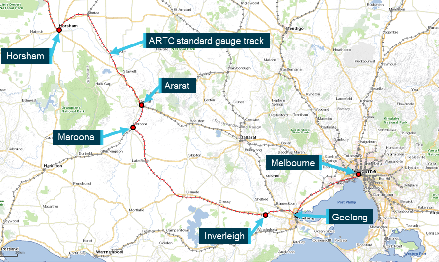
Source: e-way Electronic Street Directory Version 2.2 (c) Copyright Melway Publishing Pty. Ltd. annotated by Chief Investigator, Transport Safety
At about 0450 on 14 November, train 4PM9 travelling at about 80 km/h passed over a culvert located to the east of the township of Inverleigh. Soon after, there was a loss of brake pipe pressure[3] and the leading end of the train came to a stop across the Hamilton Highway level crossing. Ten of the original 55 wagons were still attached to the leading 5 locomotives. The next 16 wagons were derailed including 7, 5-pack articulated wagons (Figure 2).
Figure 2: Aerial view of derailed train 4PM9
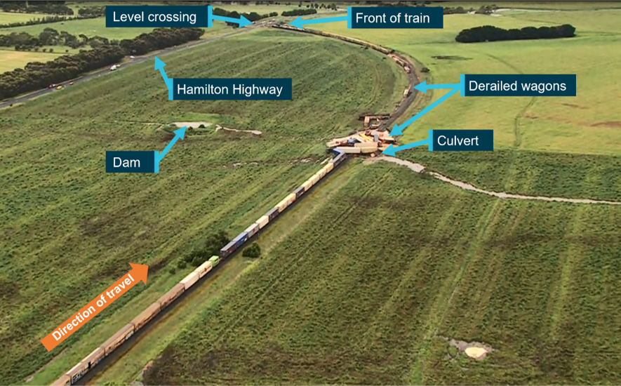
Source: Aerial footage provided by ABC News, annotated by CITS
The embankment supporting the track at the location of the culvert had collapsed (Figure 3).
Figure 3: The pipe culvert and the collapsed track formation
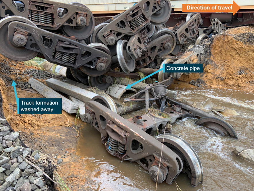
Source: Chief Investigator, Transport Safety
Context
Location
The derailment occurred about 3 km east of the township of Inverleigh on a section of track located between the Hamilton Highway and the Barwon River (Figure 4). Travelling in an easterly direction, the track ran parallel to the Hamilton Highway before curving towards and across the highway. The derailment occurred within the Mid Barwon catchment area that made up part of the Barwon drainage basin. The agricultural land on either side of the rail reserve generally sloped from the highway down towards the Barwon River. Therefore, run-off from rainfall flowed from the north side of the track through culverts (below the track) towards the Barwon River.
Figure 4: Derailment site of train 4PM9
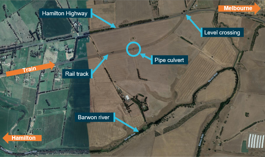
Source: Google maps, annotated by the Chief Investigator, Transport Safety
Track infrastructure
The standard gauge track at Inverleigh was a single, bi-directional line, and consisted of 60 kg/m rail fastened to concrete sleepers. The track through the location was carried on an embankment that was at a height of about 3 m at the location of the wash-away (at the culvert). This culvert was located at the 96.805 track km mark[4] and comprised of a 750 mm diameter concrete pipe embedded at the base of the embankment carrying the track.
Rainfall
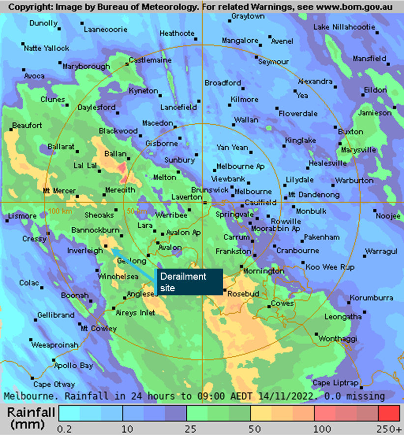
Heavy rain fell in Inverleigh from the late evening of 13 November and through the early hours of the morning of 14 November. A weather monitoring station at Gnarwarre[5], located about 12 km from Inverleigh recorded about 42 mm of rain in the 12-hour period[6] before the derailment, and local weather stations in Inverleigh recorded rainfall of around 70 mm.
Bureau of Meteorology (BoM) radar-derived[7] rainfall accumulations estimated that between 50 and 100 mm of rain fell at Inverleigh in the 24 hours to 0900 on 14 November 2022 (Figure 5).
Figure 5: Radar-derived rainfall accumulations
Source: Bureau of Meteorology, annotated by Chief Investigator, Transport Safety
Further investigation
- attended and completed derailment site inspections
- examined drainage in the waterway catchment area and commenced hydrology studies
- examined train consist and operational information
- interviewed the driver of train 4PM9
- commenced collection of other relevant information
The investigation is continuing and will include review and examination of:
- the train consist and operation of the train
- the waterway catchment area, including local catchment features
- the effect of prior rainfall on soil moisture and catchment flow
- culvert design including capacity
- track infrastructure including inspection and maintenance
- weather warnings
Should a critical safety issue be identified during the course of the investigation, the ATSB will immediately notify relevant parties so appropriate and timely safety action can be taken.
A final report will be released at the conclusion of the investigation.
Australian Transport Safety BureauAbout the ATSBThe ATSB is an independent Commonwealth Government statutory agency. It is governed by a Commission and is entirely separate from transport regulators, policy makers and service providers. The ATSB’s purpose is to improve the safety of, and public confidence in, aviation, rail and marine transport through:
The ATSB is responsible for investigating accidents and other transport safety matters involving civil aviation, marine and rail operations in Australia, as well as participating in overseas investigations involving Australian-registered aircraft and ships. It prioritises investigations that have the potential to deliver the greatest public benefit through improvements to transport safety. The ATSB performs its functions in accordance with the provisions of the Transport Safety Investigation Act 2003 and Regulations and, where applicable, international agreements. Rail safety investigations in VictoriaMost transport safety investigations into rail accidents and incidents in Victoria and New South Wales (NSW) are conducted in accordance with the Collaboration Agreement for Rail Safety Investigations and Other Matters between the Commonwealth Government of Australia, the State Government of Victoria, and the State Government of New South Wales. Under the Collaboration Agreement, rail safety investigations are conducted and resourced in Victoria by the Chief Investigator, Transport Safety (CITS) and in New South Wales by the Office of Transport Safety Investigations (OTSI), on behalf of the ATSB, under the provisions of the Transport Safety Investigation Act 2003. The Chief Investigator, Transport Safety (CITS) is a statutory position established in 2006 to conduct independent, no-blame investigation of transport safety matters in Victoria. CITS has a broad safety remit that includes the investigation of rail (including tram), marine and bus incidents. Purpose of safety investigationsThe objective of a safety investigation is to enhance transport safety. This is done through:
It is not a function of the ATSB to apportion blame or provide a means for determining liability. At the same time, an investigation report must include factual material of sufficient weight to support the analysis and findings. At all times the ATSB endeavours to balance the use of material that could imply adverse comment with the need to properly explain what happened, and why, in a fair and unbiased manner. The ATSB does not investigate for the purpose of taking administrative, regulatory or criminal action. TerminologyAn explanation of terminology used in ATSB investigation reports is available on the ATSB website. This includes terms such as occurrence, contributing factor, other factor that increased risk, and safety issue. |
[1] Of the 55 wagons, 10 were ‘5-pack’ articulated skeletal container flat wagons.
[2] Australian Eastern Daylight Time (AEDT).
[3] A loss of brake pipe pressure is often associated with a loss of brake pipe integrity and is an indication of a train parting.
[4] Rail km from Melbourne.
[5] Managed by the Department of Environment, Land Water and Planning and named Barwon River@Pollocksford
[6] From about 1700 on 13 November 2023.
[7] The BoM rainfall accumulation images are made by blending measurements from rain gauges (accurate point data) and radar. Radar data is calibrated with rain gauge data and is used to fill in the "gaps" between rain gauges.


