Preliminary report released 16 December 2024
This preliminary report details factual information established in the investigation’s early evidence collection phase and has been prepared to provide timely information to the industry and public. Preliminary reports contain no analysis or findings, which will be detailed in the investigation’s final report. The information contained in this preliminary report is released in accordance with section 25 of the Transport Safety Investigation Act 2003.
The occurrence
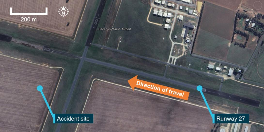
On 22 October 2024, at about 1110 local time, the pilot of a Cessna 150L registered VH‑EYU, commenced the take-off roll on runway 27[1] at Bacchus Marsh airfield, Victoria (Figure 1). Shortly after, the pilot made a radio call stating that they were rejecting the take‑off. The aircraft was then taxied off the runway and returned to the threshold of runway 27, where at 1114 the pilot recommenced the take-off.
Several witnesses at the airfield observed the second take-off and identified that, during its initial climb, the aircraft attitude pitched steeply upward. Witnesses described that the left wing dropped rapidly. The aircraft then entered a vertical descent, rotating approximately 270° before colliding heavily with terrain. The pilot (who was the sole occupant) sustained fatal injuries and the aircraft was destroyed. There was no post-impact fire.
Figure 1: Bacchus Marsh airfield and VH-EYU accident location

Source: Google Earth, annotated by the ATSB
Context
Pilot information
The pilot held a Recreational Pilot Licence (Aeroplane) and a Class 2 Aviation Medical Certificate, valid until March 2026. The pilot held a single engine aeroplane rating, and navigation endorsement. At the time of the accident, the pilot had about 184 hours total aeronautical experience, of which 3.8 hours were in Cessna 150 aircraft.
Aircraft information
The Cessna 150L is a high wing, all-metal, 2-place, single-engine aircraft with a fixed tricycle landing gear. It is powered by a 4-cylinder Teledyne-Continental O-200-A engine, driving a 2-blade fixed-pitch propeller. The aircraft was manufactured by Cessna in the United States in 1974 and first registered in Australia in May 1974. It had been owned by the Bacchus Marsh Aero Club since December 2023 (Figure 2).
The last 100-hour periodic maintenance inspection was conducted on 19 January 2024. At the time of the accident, it had accrued a total time in service of 8,962.3 hours. The aircraft had flown about 34 hours since the last scheduled maintenance which was conducted on 21 April 2024. There no known defects documented on the aircraft maintenance release.
Figure 2: VH-EYU

Source: Bacchus Marsh Aero Club
Aerodrome information
Bacchus Marsh airfield is located about 6.5 km south of Bacchus Marsh, Victoria, Australia. It is an aircraft landing area (ALA) consisting of 2 sealed north/south (01/19) and east/west (09/27) runways. The airfield was primarily used by the Bacchus Marsh Aero Club, a pilot training school and several gliding clubs.
Bacchus Marsh Aero Club
Bacchus Marsh Aero Club operates several high wing single-engine aircraft available to hire for approved club members, including the Cessna 150, 152, 172 and 182. The pilot joined the club on 19 August 2024 and subsequently completed check rides with an instructor on 13 September, 27 September and 4 October 2024.
Site information
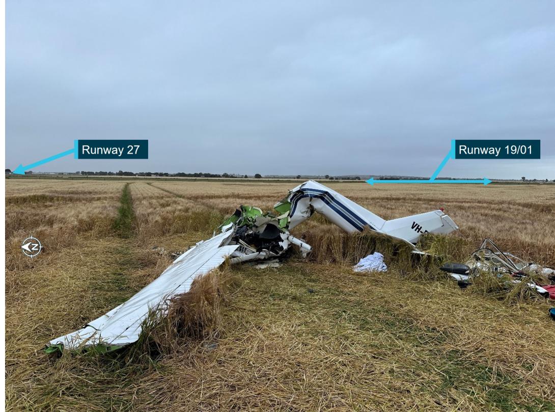
ATSB investigators first attended the accident site on 23 October 2024. The aircraft had impacted into a barley field 205 m south of the runway 27 centreline and was orientated toward the north. The damage signatures confirmed that it had impacted the field in a steep nose down attitude. Severe disruption of the cockpit area, the wing assembly and rear fuselage had occurred from the impact (Figure 3).
Figure 3: VH-EYU at the accident site near to the airfield runways

Source: ATSB
Wreckage examination
The ATSB conducted a preliminary examination of the aircraft wreckage in the field, then moved the wreckage to a secure hangar for detailed examination. The examinations identified:
- no evidence of pre-impact defects with the flight controls or structure
- all components were accounted for at the accident site
- the engine was able to be rotated and there were no obvious defects upon external examination
- the throttle setting was at idle position (low power)
- rotational damage signatures to the propeller were minimal which indicated a low engine power setting at the time of the impact
- the propeller and flange had fractured from the engine crankshaft.
A quantity of fuel was removed from the aircraft for onsite testing and was found to be clean and clear of contaminants.
Meteorological information
Forecast
The Bureau of Meteorology (BoM) issued a graphical area forecast that included the Bacchus Marsh area, at 0900 on 22 October 2024, that was valid from 1000–1600. The forecast indicated visibility greater than 10 km and no cloud.
Witness observations of the weather
Witnesses at Bacchus Marsh airfield described the wind at the time of the accident as strong and gusty, changing in direction and strength. A flight instructor stated that they had cancelled a student’s flight due to the increasingly gusty conditions which were present on the day.
Meteorological observations
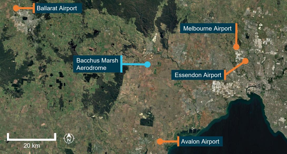
There was no BoM aerodrome weather information specifically for Bacchus Marsh, but the ATSB obtained meteorological observations for the surrounding areas of Melbourne, Essendon, Avalon and Ballarat airports (Figure 4).
Figure 4: Location of Bacchus Marsh airfield relative to nearby aerodrome weather forecast locations

Source: Google Earth, annotated by the ATSB
Table 1 shows the recorded winds in meteorological aerodrome reports (METAR)[2] and special meteorological reports (SPECI)[3] issued between 1000 and 1200 on 22 October 2024. The wind direction is in degrees true[4] rounded to the nearest 10 degrees. The wind direction and speed are the mean values over 10 minutes, and the gust is the maximum wind speed over a 2-minute period.
Table 1: Aerodrome wind observations
| Time | Melbourne | Essendon | Avalon | Ballarat |
|---|---|---|---|---|
| 1000 | 010° 22 kt | 360° 15 kt | 020° 8 kt | 360° 13 kt |
| 1007[1] | 020° 21 kt gusting to 32 kt | |||
| 1020[1] | 360° 17 kt gusting to 27 kt | |||
| 1030 | 020° 20 kt | 360° 16 kt | 360° 10 kt | 360° 13 kt |
| 1100 | 010° 20 kt | 360° 18 kt | 330° 12 kt | 360° 10 kt |
| 1130 | 010° 19 kt | 360° 15 kt | 350° 12 kt | 360° 14 kt |
| 1200 | 010° 17 kt | 360° 15 kt | 350° 11 kt | 360° 16 kt |
[1] SPECI
Further investigation
To date, the ATSB has:
- examined the aircraft wreckage
- conducted witness interviews
- reviewed common traffic advisory frequency recordings
- reviewed CCTV footage and mobile phone footage
- obtained weather information.
The investigation is continuing and will include:
- further review of the pilot’s experience, qualifications and training
- further review and analysis of recorded CCTV and mobile phone footage
- further analysis of the weather conditions
- examination of the aircraft maintenance history.
A final report will be released at the conclusion of the investigation. Should a critical safety issue be identified during the course of the investigation, the ATSB will immediately notify relevant parties so appropriate and timely safety action can be taken.
Purpose of safety investigationsThe objective of a safety investigation is to enhance transport safety. This is done through:
It is not a function of the ATSB to apportion blame or provide a means for determining liability. At the same time, an investigation report must include factual material of sufficient weight to support the analysis and findings. At all times the ATSB endeavours to balance the use of material that could imply adverse comment with the need to properly explain what happened, and why, in a fair and unbiased manner. The ATSB does not investigate for the purpose of taking administrative, regulatory or criminal action. TerminologyAn explanation of terminology used in ATSB investigation reports is available here. This includes terms such as occurrence, contributing factor, other factor that increased risk, and safety issue. Publishing informationReleased in accordance with section 25 of the Transport Safety Investigation Act 2003 Published by: Australian Transport Safety Bureau © Commonwealth of Australia 2024
Ownership of intellectual property rights in this publication Unless otherwise noted, copyright (and any other intellectual property rights, if any) in this report publication is owned by the Commonwealth of Australia. Creative Commons licence With the exception of the Commonwealth Coat of Arms, ATSB logo, and photos and graphics in which a third party holds copyright, this report is licensed under a Creative Commons Attribution 4.0 International licence. The CC BY 4.0 licence enables you to distribute, remix, adapt, and build upon our material in any medium or format, so long as attribution is given to the Australian Transport Safety Bureau. Copyright in material obtained from other agencies, private individuals or organisations, belongs to those agencies, individuals or organisations. Where you wish to use their material, you will need to contact them directly. |
[1] Runway number: the number represents the magnetic heading of the runway. In this case, 27 represents a magnetic heading of 270°.
[2] METAR: a routine aerodrome weather report issued at half hourly time intervals.
[3] SPECI: a special aerodrome weather report issued only when meteorological parameters meet specific criteria.
[4] The magnetic variation at Bacchus Marsh was 11° east.


