Executive summary
What happened
On the morning of 28 October 2023, a SOCATA-Groupe Aerospatiale TB-20, registered, VH-JTY, departed Montpelier aircraft landing area, Queensland, for a visual flight rules private flight to Palmyra aircraft landing area, Queensland. The flight was to be just over one hour duration and the pilot and their passenger were familiar with the route.
During the flight, the pilot contacted a friend at the destination for an appreciation of the weather. After the friend advised them of the prevailing conditions including cloud, the pilot replied that they would need to go through some cloud before arriving.
Around 30 NM from the destination, shortly after commencing descent for the intended landing, the aircraft began a steep descending turn to the left towards mountainous terrain. During this descent, the aircraft exceeded the airframe’s designed maximum airspeed before pitching up and passing over the top of Bull Mountain. The aircraft then entered a second steep descending turn, this time to the right, before the recorded flight path data ceased.
The wreckage was located nearby in dense forest on the north-east face of Bull Mountain. The accident site indicated that the aircraft had collided with terrain at a steep angle, and with significant forward velocity. The aircraft was destroyed and both occupants received fatal injuries.
What the ATSB found
The ATSB found that, after encountering cloud en route, the pilot elected to continue along the intended flight path through cloud instead of diverting around or remaining on top of it. Shortly after, it is very likely the pilot entered weather conditions not suitable for visual navigation, leading to spatial disorientation and a descent into mountainous terrain.
Safety message
One of the key risk controls for a visual flight rules (VFR) pilot to avoid entering instrument meteorological conditions (IMC) is appropriate pre-flight preparation and planning. Pilots should always obtain up-to-date weather information before and during flight. While forecasts will assist in selecting the route to be flown, pilots should plan an alternate or be prepared to make necessary deviations from the planned route should actual weather conditions indicate the possibility of not being able to comply with the VFR.
For a non-instrument rated pilot, even with basic attitude instrument flying proficiency, maintaining control of an aircraft in IMC by reference to the primary flight instruments alone entails a very high workload that can result in narrowing of attention and loss of situational awareness. While autopilot can be used to reduce workload, it is not infallible and should not be relied upon or used by VFR pilots as a risk mitigator to decide to fly into unsuitable conditions.
Unapproved mobile devices displaying charts and data from an approved data service provider are a useful supplement to navigation, but they cannot be used as a navigation device, and must not be the sole means of navigation when operating under the VFR. Pilots should use navigation equipment approved for aviation and maintain skills in navigating by reference to approved charts.
The investigation
The occurrence
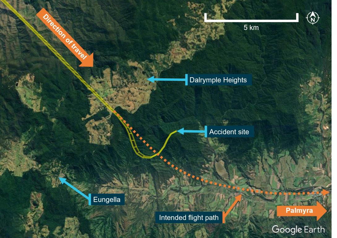
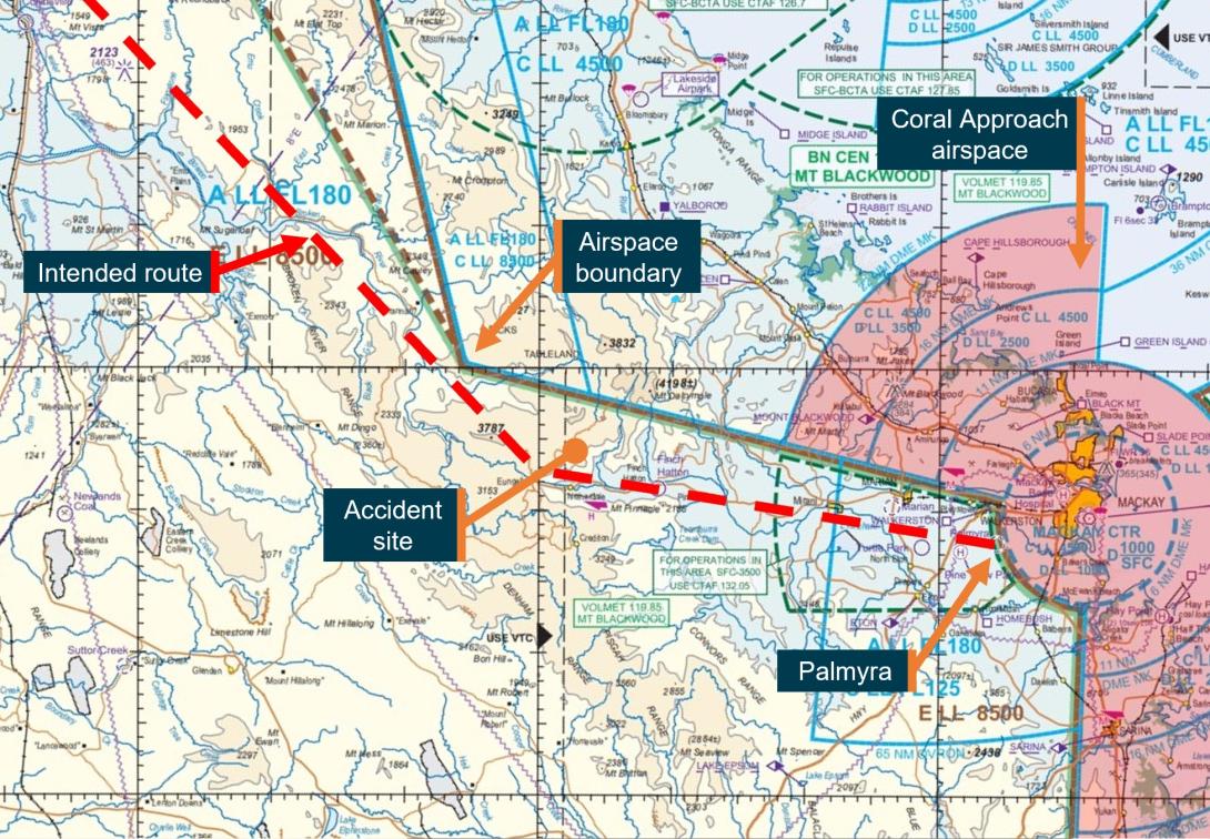
On 28 October 2023, at about 0735 local time, a SOCATA-Groupe Aerospatiale TB-20 (TB-20) registered VH-JTY, departed from Montpelier (Antill Plains) aircraft landing area,[1] Queensland, for a private flight to Palmyra aircraft landing area,[2] Queensland. The flight was to track via Dalrymple Heights, near Eungella before descending into the Pioneer Valley to the west of Mackay, and then track direct to Palmyra (Figure 1). On board were the pilot and a passenger, who was also a licenced pilot.
Figure 1: VH-JTY fight path
Source: Google Earth and OzRunways, annotated by the ATSB
OzRunways[3] data showed the aircraft was flown to 5,500 ft above mean sea level (AMSL) where it maintained a steady track without any significant deviations during the cruise phase of flight.
At 0814, approximately 20 minutes prior to commencing descent for the intended landing at Palmyra, the pilot made a phone call to a friend, another licenced pilot, in Mackay. It was reported that the pilot enquired about the weather at the destination. The friend recalled advising of the presence of cloud at Palmyra and blue sky to the south of the landing area. The pilot replied that they would have to go through some cloud.
The same friend called the pilot at 0833 to confirm their estimated time of arrival so they could meet the pilot in Palmyra. They stated that the pilot reported being over Eungella at 5,500 ft and was about to commence their descent. The friend reported ending the phone call so as not to cause any distraction.
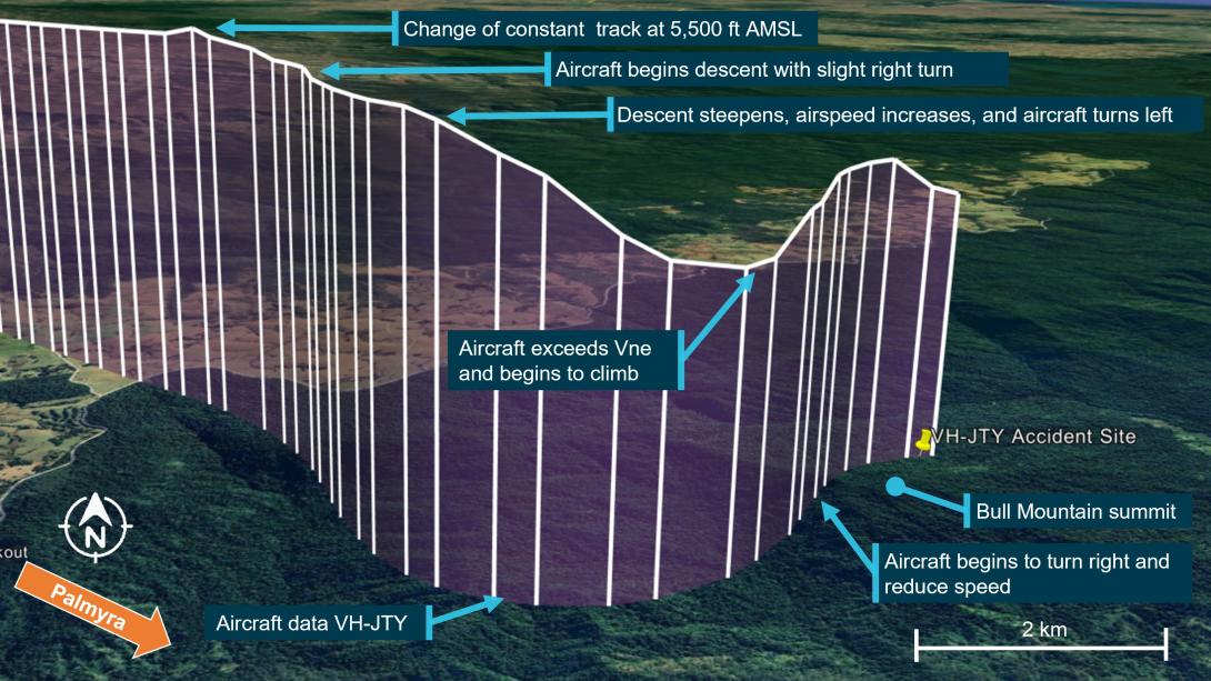
At 08:34, there was a change to the previously stable flight path. The aircraft initially climbed about 100 ft and entered a slight right turn before turning left towards Bull Mountain in a shallow descent. As the turn continued, the aircraft’s descent rate increased, descending about 1,600 ft in 13 seconds (average descent rate of 7,400 ft/min) (Figure 2).
Figure 2: VH-JTY descent
Source: Google Earth with overlaid OzRunways data, annotated by the ATSB
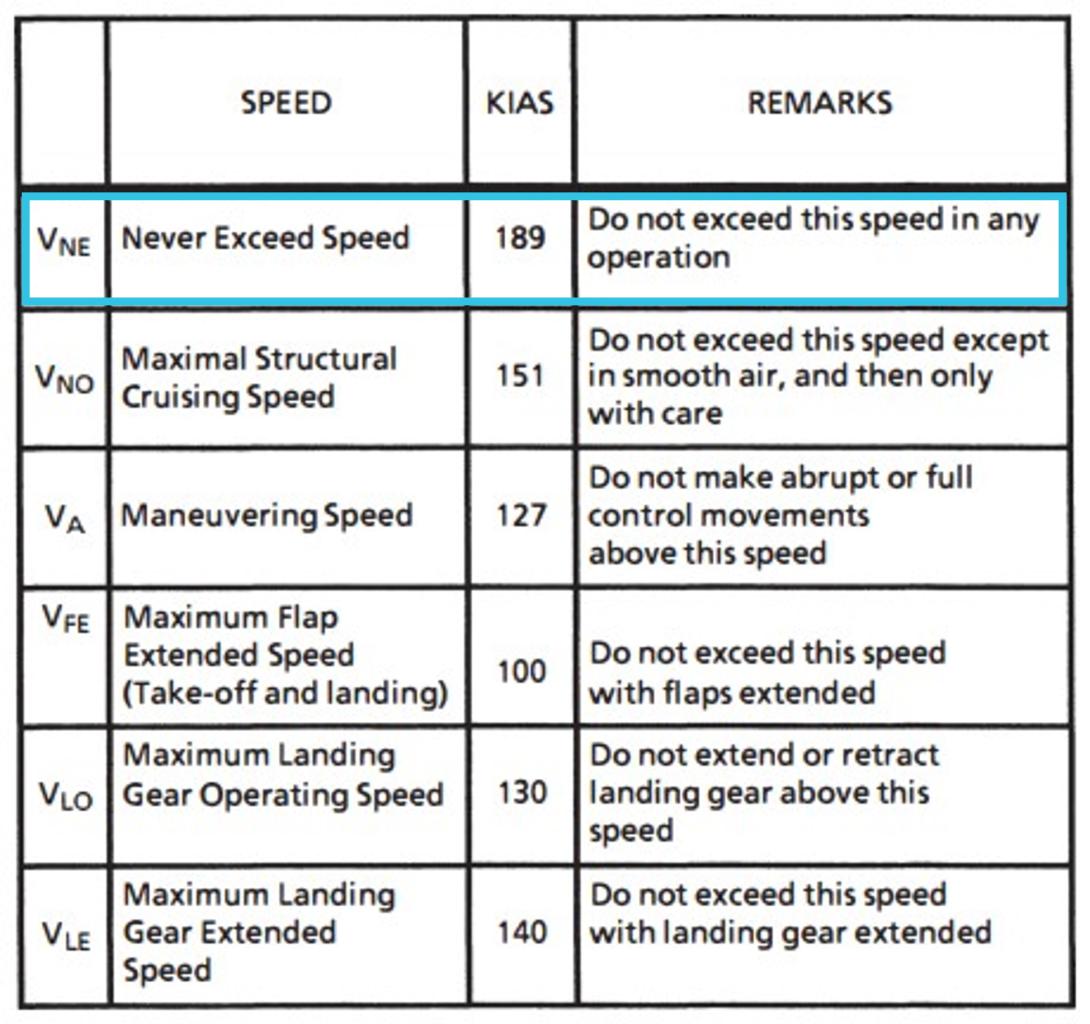
During this descent, the aircraft accelerated to about 218 kt, 29 kt above the aircraft’s published VNE[4] (velocity never exceed) of 189 kt (Figure 3).
Figure 3: TB-20 airspeed limitations
Source: Aircraft manufacturer, annotated by the ATSB
In the 10 seconds that followed, the aircraft pitched up steeply, climbed approximately 600 ft, and passed overhead Bull Mountain at 4,200 ft AMSL. The aircraft then slowed to 132 kt before entering a steep descending right turn to the east. The recorded data stopped at 0835, 3,655 ft AMSL with the aircraft estimated to be descending at around 6,000 ft/min in a right turn with 36° angle of bank and increasing roll angle.
The aircraft collided with terrain in dense forest on the north-east face of Bull Mountain 1,900 ft AMSL, not far from where the recorded data stopped. The aircraft was destroyed, and the pilot and passenger were fatally injured.
Context
Pilot information
The pilot was qualified and authorised to fly VH-JTY. They held a valid Private Pilot Licence (Aeroplane), issued on 4 May 2004. In addition, the pilot held a single engine aeroplane rating, and endorsements for manual propeller pitch control and retractable undercarriage. Their last flight review was conducted in July 2023 and valid to 30 September 2025. At the time of the accident the pilot had about 2,100 hours total aeronautical experience of which about 1,500 hours were in VH-JTY.
The pilot held a valid class 2 medical certificate that was issued on 12 December 2022 and valid to 7 October 2024. The class 2 was issued with the restrictions that both distance and reading vision correction was available during flight. A review of the pilot’s medical records showed that a chronic medical condition was being appropriately managed by the pilot and their designated aviation medical examiner (DAME). It required annual review and there were no additional restrictions placed on the pilot’s class 2 medical certificate.
A copy of the coroner’s toxicology and pathology reports were not available to the ATSB at the time of publishing this report.
Passenger information
The passenger was familiar with VH-JTY. While a licensed pilot, they had not renewed their medical certification for flight and had not conducted a recent flight review.
Aircraft information
General information
The TB-20 is an all-metal, 5-place, single engine aircraft with fully retractable landing gear. It was powered by a 6-cylinder Lycoming IO-540 fuel-injected engine, driving a 3-blade constant-speed propeller and equipped[5] for visual flight rules (VFR)[6] (Day) flying only. VH-JTY was manufactured in France in 1985 and was first registered in Australia in April 1987. The pilot had owned VH-JTY since April 2008 (Figure 4).
Figure 4: VH-JTY
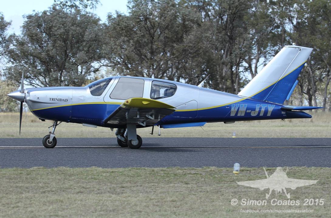
VH-JTY as it appeared in 2015. The yellow lines and wingtips were later painted dark red.
Source: Simon Coates, modified by the ATSB
Maintenance history
The aircraft was maintained in accordance with the CASA system of maintenance defined in Civil Aviation Regulations 1988 - Schedule 5 and the last periodic inspection was conducted on 14 December 2022. A review of the maintenance records and history for VH-JTY did not show any outstanding defects. The active maintenance release was not recovered from the accident site.
The aircraft was equipped with a Bendix/King KLN 90 GPS navigation system and a Bendix/King KAP 150 2-axis (pitch and roll) autopilot system that had been installed since the aircraft was manufactured. A review of the maintenance history and comments of the approved maintenance organisation showed minor issues with the autopilot consistent with its age. The faults were reported to have resulted in the uncommanded disconnection of the autopilot in flight. The unit was repaired in March 2022 and there were no records of any further maintenance on the autopilot after this date.
In January 2023, a ground handling incident damaged VH-JTY’s vertical fin and rudder. Structural repairs were carried out and following inspection of the flight controls, the aircraft returned to service on 25 May 2023. At the time of the accident, VH-JTY had a total time in service of about 5,233.4 hours and had flown about 35 hours since return to service.
King KAP 150 Autopilot
The pilot information manual supplement for the autopilot did not provide a minimum activation airspeed for the TB-20 but did contain a maximum airspeed limitation of 175 kt for autopilot use. Automatic flight could be activated by pressing the AP ENG (autopilot engage) button on the control panel and disengaged by pressing the AP ENG button again, or by pressing the AP DISC (autopilot disconnect) button on the pilot’s control wheel. When the autopilot is disengaged, an aural alert sounds for 2 seconds to alert the pilot.
The supplement also provided maximum altitude losses that may be encountered following an autopilot malfunction. In a cruise, climb or descent configuration, the maximum altitude loss would be 450 ft.
Recorded data
ADS-B
The aircraft was equipped with a SkyEcho portable automatic dependant surveillance broadcast (ADS-B) antenna capable of receiving information from ADS-B equipped aircraft and transmitting positional information to nearby stations. A review of available flight track history revealed that this antenna did not transmit any positional information during the accident flight.
Mobile devices
There were almost certainly 2 iPads and 2 telephones onboard the aircraft. Queensland Police located and recovered one telephone from the accident site. ATSB data recovery specialists determined that the phone was too heavily damaged to recover the data from the phone’s internal memory. At least 2 mobile devices were running the OzRunways app.
OzRunways data
OzRunways is an electronic flight bag (EFB) provider in Australia that also provides a ‘TX’ service that tracks device location and uploads it to OzRunways servers over the cellular network every 5 seconds. This service displays the device’s location on a user‑selected chart and also plots location data from other aircraft utilising OzRunways. The pilot used the OzRunways application on an iPad for en route planning and navigation. The pilot’s passenger also carried a second iPad with OzRunways when they flew together.
OzRunways is an approved source of aeronautical charts, but it must not be used as a primary means of navigation. The iPad GPS does not meet technical standard order[7] (TSO) specifications for aviation use (OzRunways, 2022). Additionally, there are limitations to the data provided via OzRunways. Altitude information has a resolution of 100 ft, a change in altitude from 190 ft to 210 ft will be displayed as a change from 100 ft to 200 ft. Additionally, filtering applied to smooth the data can affect the accuracy of analysis of small sections of data.
Tracking data obtained from OzRunways provided latitude and longitude as well as time, speed and heading. The last data point was at an altitude of about 1,700 ft above ground level in the vicinity of the accident site (Figure 2). When the OzRunways data ended, the aircraft was shown heading east in a steep descending right turn. The lack of any further data points was probably due to a loss of cellular signal among the mountains.
Accident site
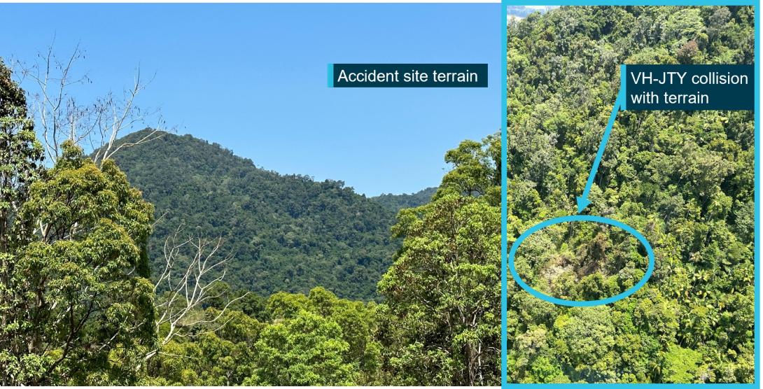
The aircraft wreckage was located in heavily vegetated steep mountainous terrain, north-east of Bull Mountain (Figure 5). A Central Queensland Rescue helicopter located the wreckage at 1113 on 28 October and first accessed the site by winch at about 1400 on the day of the accident. The rescue crew confirmed that both occupants were deceased and took preliminary photographs of the wreckage.
The ATSB was unable to access the accident site. ATSB investigators provided a briefing to Queensland Police Service (QPS) forensic officers prior to them attending site on 27 November. With the support of specialists trained in high angle rescue operations the QPS officers collected evidence and provided it to the ATSB.
Figure 5: Accident site terrain
Source: Central Queensland Rescue, annotated by the ATSB
Wreckage examination
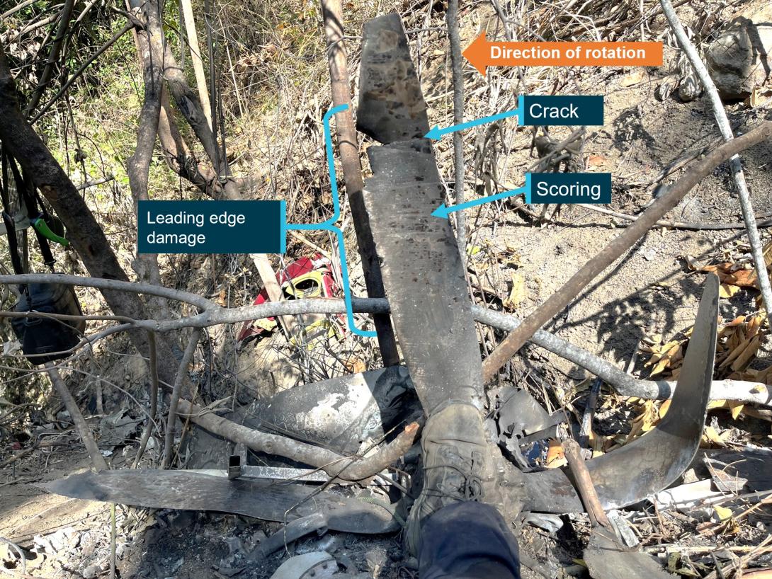
The ATSB’s review of the accident site photographs, and evidence provided by QPS, showed that the aircraft impacted the terrain at a steep angle while tracking 036° (close to north-east). The aircraft was destroyed by the impact and consumed by a post-impact fuel‑fed fire. Several components were buried by shifting soil after the accident.
Figure 6: Propeller damage
Source: Queensland Police Service, annotated by the ATSB
The following observations were made from the wreckage examination:
- Impact marks on engine and propeller components indicated that the propeller was turning with power applied when it impacted terrain, indicating the engine was almost certainly operational at that time (Figure 6).
- The extremities of the aircraft, the wing tips and stabilator were found at the accident site indicating that the aircraft was complete at the time of collision.
Communications
Police contacted Mackay air traffic control tower following the report of a missing aircraft. The controller confirmed that they did not hear a radio transmission from VH-JTY and that aircraft operating in the area at the time did not hear a distress call from the aircraft.
Operational information
General
Peers of the pilot reported that the pilot would often climb to operate VFR over the top of cloud. The pilot would generally fly the cruise portion of the flight on autopilot and would use the autopilot if they ever had to fly through cloud. While VFR over the top of cloud is permitted under the VFR, a minimum separation from cloud is required when flying under the VFR (see section Visual meteorological conditions).
The Civil Aviation Authority of New Zealand safety publication Vector contained an article called Who’s really flying your aircraft? The article discussed the potential downfalls of relying on automation in the cockpit, and its prevalence in VFR into instrument meteorological conditions (IMC) accidents.
VH-JTY was fitted with an approved GPS. The pilot was not known to program flight plans into the unit, instead relying on OzRunways for navigation. The CASA Visual Flight Guide provided the following note to VFR pilots utilising GPS in their aircraft:
An approved GNSS system may be used under the VFR:
- to supplement map reading and other visual navigation techniques
- to derive distance information for enroute navigation and traffic separation.
The positioning and navigational tools featured in the OzRunways application rely on equipment such as mobile phones or iPads that do not meet the required standard for operational use in aircraft. OzRunways acknowledges this limitation and advises users that the OzRunways application shall not be used as a primary means of navigation. It can, however, be used to supplement traditional visual navigation methods such as map reading.
Previous flights
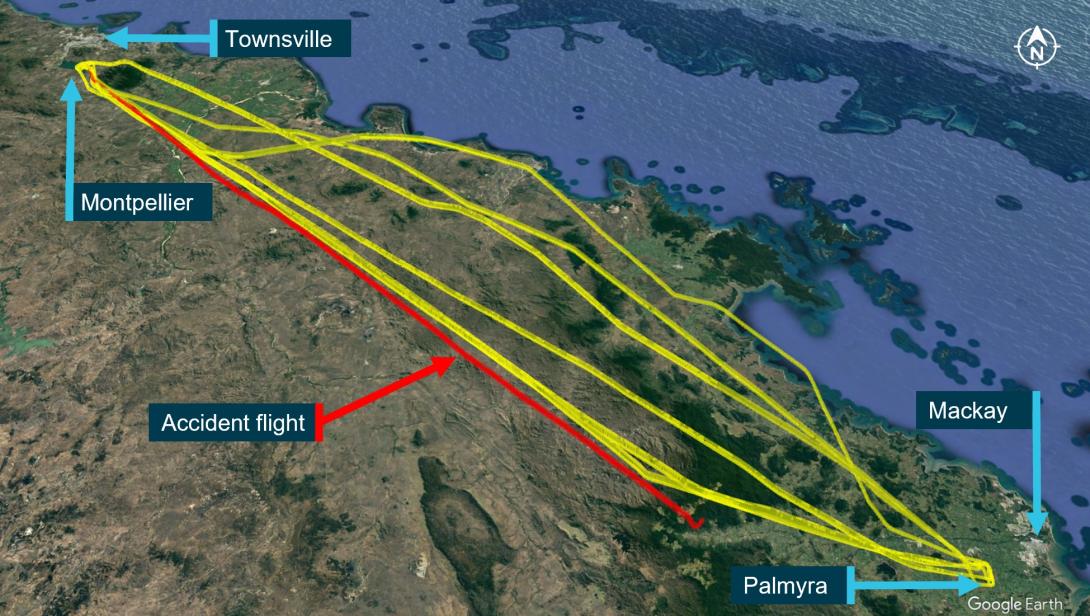
Data obtained for the previous 3 months showed a number of previous flights between the two locations consistent with logged flight records (Figure 7). Each flight took about 1.2 hrs depending on the route taken.
Flights would often depart Palmyra, tracking inland towards Townsville where they would descend outside the Townsville control zone steps and land at Montpelier Airfield. On return to Palmyra, the pilot routinely flew inland past Collinsville and would descend down the Pioneer Valley approaching Palmyra from the west below the Mackay control zone steps.
Figure 7: Previous flight data
Source: Google Earth and OzRunways, annotated by the ATSB
Selection of route
The pilot and their passenger were familiar with the route between Montpelier and Palmyra, completing the return journey as often as once a fortnight for the last few years. When they considered the weather unsuitable for flight, they would make the trip by car, and had a vehicle at their disposal in both locations.
The pilot was known to plan routes that were outside controlled airspace (Figure 8). Witnesses interviewed advised this was common practice among local pilots due to the potential of encountering delays in access to controlled airspace in that region.
Figure 8: Intended flight path
Source: Visual Navigation Chart, annotated by the ATSB
Visual meteorological conditions
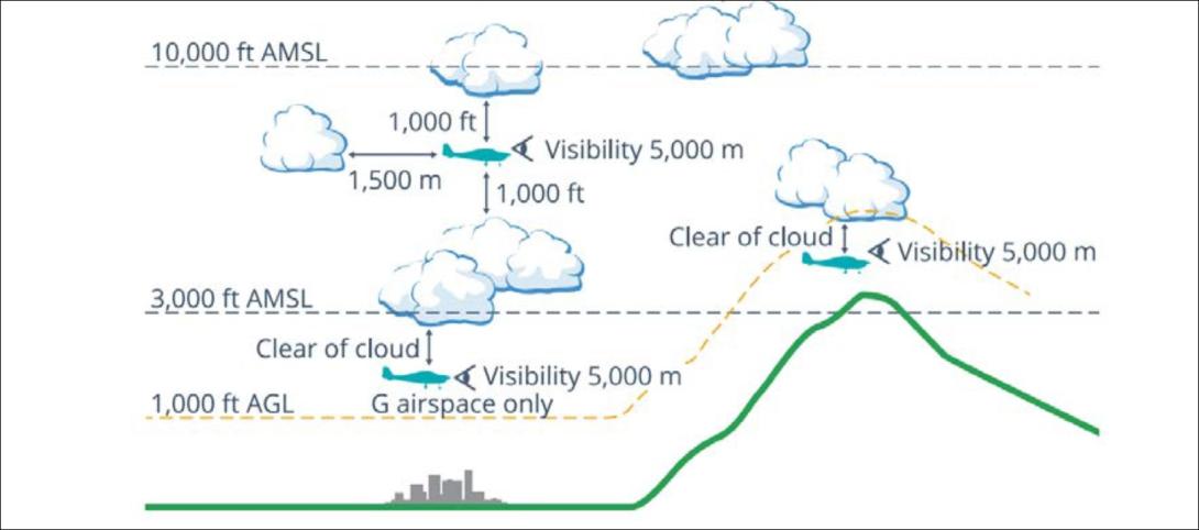
Visual meteorological conditions (VMC) are expressed in terms of in-flight visibility and distance from cloud (horizontal and vertical) and are prescribed in the Civil Aviation Safety Regulations (CASR) Part 91 (General Operating and Flight Rules) Manual of Standards 2020: 2.07 VMC criteria. A VFR flight can be conducted above cloud provided VMC can be maintained for the entire flight, including climb, cruise, and descent.[8] The CASA Visual Flight Rules Guide included the following notes for VFR flight:
Pilots should not initiate VFR flight on top of more than SCT [scattered][9] cloud when weather conditions are marginal. Before committing to operate VFR flight on top of more than SCT cloud, pilots should be confident that meteorological information used is reliable and current, and clearly indicates that the entire flight will be able to be conducted in VMC.
And:
When navigating by visual reference to the ground or water, you must positively fix the aircraft’s position by visual reference to features marked on topographical charts at intervals not exceeding 30 minutes.
Figure 9, taken from the CASA Visual Flight Rules Guide, provides a visual depiction of the VMC criteria for aeroplanes below 10,000 ft.
Figure 9: VMC criteria below 10,000 ft
Source: Civil Aviation Safety Authority
Weather reports obtained by the pilot
According to CASR Part 91 (General Operating and Flight Rules) Manual of Standards 2020: 7.02 Forecasts for flight planning, an authorised weather forecast must cover the whole period of the flight, and include a wind and temperature forecast and, for a flight at or below 10,000 ft AMSL, a general aviation meteorological area forecast (GAF).
Airservices Australia conducted a review of the pilot’s national aeronautical information processing system (NAIPS)[10] account activity. Two accounts were linked to the pilot. On the day of the flight, one account had expired, and the other had not been accessed since a password update 2 months earlier. Weather requests through OzRunways use the user’s NAIPS login credentials to retrieve the requested information. A third account, linked to the passenger, was last accessed through OzRunways 5 days prior to the flight to obtain an area briefing.
While other third party information such as weather radar overlays, satellite imagery and wind observations are available without an NAIPS login,[11] NAIPS is the only source through which OzRunways obtains weather forecasts for flight planning.
Notwithstanding the requirement of a forecast for flight planning, CASR Part 91 (General Operating and Flight Rules) Manual of Standards 2020: 7.03 Flights unable to obtain an authorised weather forecast before departure states that a flight can still depart without an authorised forecast provided other conditions are met. These include:
The pilot in command reasonably considers that the weather conditions at the departure aerodrome will permit the aircraft to return and land safely at the departure aerodrome within 1 hour after take-off.
The pilot in command of a Part 91 flight must return to the departure aerodrome if:
(a) the authorised weather forecast required for the planned destination aerodrome is not obtained within 30 minutes after take-off; and
(b) the pilot in command has not nominated a destination alternate aerodrome if required to do so by subsection 8.04 (3).[12]
CASA defined what constituted an approved weather report and a list of who could provide one.[13] Licenced pilots were included in the list. The pilot obtained a weather update for the destination from their friend en route. While the accuracy of the information could not be verified, as a licenced pilot, the weather report provided by the pilot’s friend would have been considered an approved weather report for the destination. Based on the pilot’s phone records, this report was obtained about 39 minutes after departure.
Meteorological information
Forecast weather
The planned flight from Montpelier to Palmyra was within the QLD north (QLD-N) Graphical Area Forecast (GAF)[14] region. Forecast weather conditions in the GAF, valid from 0300 to 0900 on 28 October 2023, included average conditions of greater than 10 km visibility with areas of scattered stratocumulus clouds between 2,000 and 4,000 ft. The cloud was forecast to lift and become scattered cumulus and stratocumulus between 4,000 and 8,000 ft with moderate turbulence below 8,000 ft in thermals later in the day.
The Bureau of Meteorology aerodrome forecast (TAF)[15] for Mackay Airport, issued at 0435 and valid at the time of the accident showed an expected visibility of greater than 10 km, few cloud at 3,000 ft and a wind of 17 kt from the south-east.
Based on the forecasts, local pilots interviewed by the ATSB described the conditions as being conducive to mechanical turbulence around the ranges.
Actual weather
The meteorological aerodrome report (METAR)[16] for Mackay Airport reported wind from the east at 17 kt (100°), visibility greater than 10 km and cloud scattered at 3,300 ft and broken[17] at 5,500 ft. There was no rainfall recorded in the previous 24 hours.
The ATSB requested an assessment of the weather from the Bureau of Meteorology who provided the following observations for the morning of the accident:
- Cloud extended from the coast to the ranges and was clear west of ranges.
- South easterly winds persisted which often bring cloud between 2,000 – 3,000 ft, being lower earlier in the day and climbing as the day warms up.
- Over the accident site, cloud was overcast to broken.
- Cloud extended 25 NM south of accident site.
- Eungella Dam was visible to the west on satellite images.
- Closer to the coast cloud was scattered to broken.
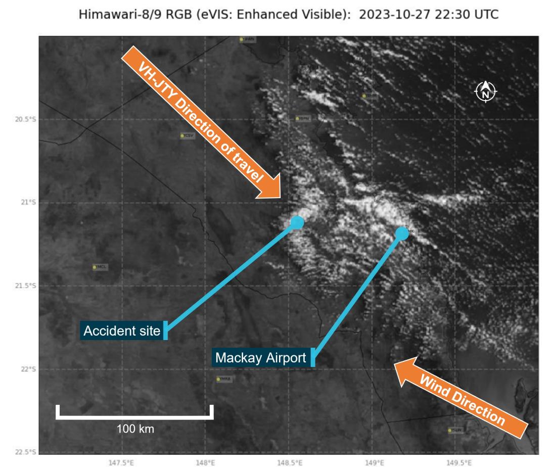
Bureau of Meteorology satellite images showed cloud building in the Pioneer Valley east of the ranges from 0600, covering the mountains to the north of the Pioneer Valley by 0800. Figure 10 shows cloud cover at 0830, 3 minutes before the accident.
Figure 10: Satellite image showing cloud formation on 28 October at 0830 local time
Source: Source: Bureau of Meteorology, annotated by the ATSB
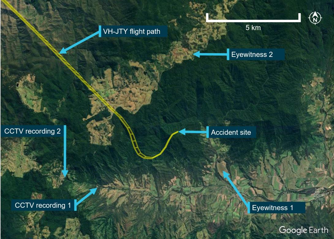
Figure 11 shows the location of witnesses and CCTV recorded at the time of the accident.
- Eyewitness 1 located near Bull Mountain heard a low flying aircraft that stopped suddenly. They stated that the top of the mountain was visible around the time of the accident.
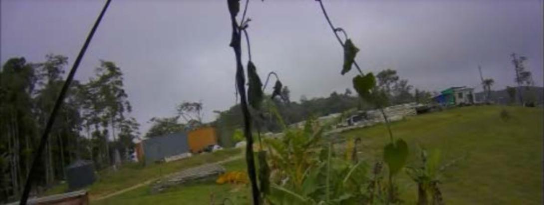
- Eyewitness 2 described the cloud as being very thick that morning from when they woke at 0500. The cloud started to rise around 0800 but still produced limited visibility of their paddock until around 1000. They also described a ‘good breeze’ on the ground during the morning with occasional gusts but did not recall strong winds on the day. CCTV footage from that location showed low cloud close to where the pilot commenced their descent (Figure 12).
- CCTV recording 1 obtained from a business 5 km south-west of the accident site showing diffuse light indicating cloud cover at the time of the accident.
- CCTV recording 2 facing north from an elevated position at the head of the valley. That footage showed low cloud to the east and tree movement equivalent to a fresh breeze.
Additionally, a large bushfire around 70 km to the south-east had filled the Pioneer Valley with smoke which was yet to dissipate. The pilot of the rescue helicopter advised that during the search for VH-JTY at around 1000, the cloud base was scattered at 3,000 ft with poor visibility in smoke haze.
Figure 11: Witness locations
Source: Google Earth, annotated by the ATSB
Figure 12: Closed circuit footage from Dalrymple Heights
Source: Supplied
Decision making
Flight under the VFR requires minimum conditions of visibility and distance from cloud. Variation from the expected weather conditions en route may prevent a pilot from reaching their destination under this ruleset. Flying into instrument meteorological conditions[18] (IMC) can occur in any phase of flight. However, a 2005 ATSB research publication – General Aviation Pilot Behaviours in the Face of Adverse Weather (B2005/0127) – concluded that the chances of a VFR into IMC encounter increased as the flight progressed, with the maximum chance occurring during the final 20 per cent of the planned flight. It stated:
This pattern suggests an increasing tendency on the part of pilots to ‘press on’ as they near their goal. To turn back or divert when the destination seemed ever closer became progressively more difficult.
The CASA Resource Booklet 7 Decision making contained the following:
A non-instrument rated pilot who proceeds with a flight in marginal weather and ends up in instrument meteorological conditions (IMC) decides to firstly, proceed with the flight and secondly, not turn back when the weather indicated visual flight rules were not able to be maintained
Dejoy (1992, cited in Hunter, 2002) suggests that a person’s propensity to engage in risky behaviour is the result of lower perceived risk in the outcome. Studies have shown that pilots who do not perceive the risks with adverse weather are more likely to engage in higher risk activities when dealing with weather (Cooper, 2003).
A Transportation Safety Board of Canada report A23O0028 into a VFR into IMC accident looked at pilot decision making and the acceptance of unsafe practices.
Pilot decision making is a cognitive process used to select a course of action between alternatives. Several factors, circumstances, and biases can affect pilot decision making, including the flight objective or goal, and the pilot’s knowledge, experience, and training. These factors can lead to situations where pilots might prioritize the achievement of the goal over the management of threats, likely resulting in a reduced safety margin.
A focus on achieving a goal or outcome may lead to a reduced sensitivity to risk, especially when high-risk activities repeatedly result in no negative outcomes. Flight crew members may grow accustomed to these risks, altering their perception and acceptance of such risks over time (Hollenbeck and others 1994).
Spatial awareness
The ATSB publication Avoidable Accidents No. 4: Accidents involving Visual Flight Rules pilots in Instrument Meteorological Conditions (AR-2011-050) discusses the physiological limitations of the human body when trying to sense its orientation in space.
In conditions where visual cues are poor or absent, such as in poor weather, up to 80 per cent of the normal orientation information is missing. Humans are then forced to rely on the remaining 20 per cent, which is split equally between the vestibular system and the somatic system. Both of these senses are prone to powerful illusions and misinterpretation in the absence of visual references, which can quickly become overpowering.
Pilots can rapidly become spatially disoriented when they cannot see the horizon. The brain receives conflicting or ambiguous information from the sensory systems, resulting in a state of confusion that can rapidly lead to incorrect control inputs and resultant loss of aircraft control.
For non-instrument rated pilots, statistics show they may not be able to recover at all. Research has shown the pilots not proficient in maintaining control of an aircraft with sole reference to the flight instruments will typically become spatially disoriented and lose control of the aircraft within 1 to 3 minutes after visual cues are lost.
The FAA Advisory Circular FAA AC60-4A Pilot’s spatial disorientation discussed the challenges associated with recovering from spatial disorientation. The results of a test conducted with qualified instrument pilots found that it took as much as 35 seconds to establish full control by instruments after the loss of visual reference with the ground or surface.
The ATSB report AR-2011-050 was updated in 2019 and found that in the 10 years prior, there were 101 VFR into IMC occurrences in Australian airspace reported to the ATSB. Of these, 9 were accidents resulting in 21 fatalities. An almost 10% chance of the encounter ending in a fatal accident.
A search of the ATSB Aviation Occurrence Database shows that in the 5 years since 2019, there have been 56 VFR into IMC occurrences reported to the ATSB. Of these, 10 resulted in accidents with 16 fatalities. The dangers of spatial disorientation following a loss of visual cues remains one of the most significant causes of concern in aviation safety.
Similar Occurrences
The risks of visual flight rules (VFR) pilots flying from visual meteorological conditions (VMC) into instrument meteorological conditions (IMC) are well documented, and have been the focus of numerous ATSB reports and publications. VFR pilots flying into IMC is a significant cause of aircraft accidents and fatalities.
AO-2022-016 – VFR into IMC, loss of control and collision with terrain involving Airbus Helicopters EC130 T2, VH-XWD, near Mount Disappointment, Victoria, on 31 March 2022
On 31 March 2022, at about 0741 local time, 2 Microflite Airbus EC130 helicopters, registered VH‑WVV and VH-XWD, departed the Batman Park helicopter landing site in Melbourne, for the town of Ulupna, Victoria. Both helicopters were operated in accordance with the VFR and departed in VMC conditions. Cloud was forecast along the route, but the pilots elected to continue to the destination. The helicopters encountered instrument meteorological conditions (IMC) over Mount Disappointment and VH-WVV conducted a U-turn to avoid entering cloud. While also attempting to conduct a U-turn, VH-XWD entered cloud, developed a high rate of descent, and collided with terrain. The helicopter was destroyed, and the 5 occupants were fatally injured.
AO-2021-017 – VFR into IMC and in-flight break-up involving Van's Aircraft RV-7A, VH-XWI 90 km south of Charters Towers, Queensland, on 23 April 2021
On 23 April 2021, a Van’s Aircraft RV-7A, registered VH-XWI, was being operated on a private flight under the visual flight rules (VFR) from Winton to Bowen, Queensland. During the flight, the pilot most likely entered IMC and lost control of the aircraft several times. This led to the airspeed limitations for the aircraft being exceeded and the aircraft sustained an in-flight break-up. The pilot was fatally injured, and the aircraft was destroyed.
VFR into IMC resources
The 2011 ATSB publication, Accidents involving Visual Flight Rules pilots in Instrument Meteorological Conditions, updated in 2019, includes a selection of weather-related general aviation accidents and incidents that show weather alone is never the only factor affecting pilot decisions that result in inadvertent IMC encounters. The documented investigations consistently highlight that conducting thorough pre-flight planning is the best defence against flying into deteriorating weather.
CASA also released a collection of resources related to this type of occurrence on its website titled Preventing VFR into IMC and other related resources on its pilot safety hub under Weather and forecasting.
For more information on VFR into IMC occurrences, recognising inadvertent entry into IMC, and what to do to recover, refer to the following publications:
- Civil Aviation Authority United Kingdom: Safety sense booklet VFR flight into IMC
- Aircraft Owners and Pilots Association: Encountering IMC
Safety analysis
The analysis considers the limited evidence available and discusses possible explanations for the departure from controlled flight:
- pilot incapacitation
- technical failure or malfunction
- decision making
- spatial disorientation.
Pilot incapacitation
Pilot incapacitation following a medical event was considered unlikely based on the short timeframe between ending the phone conversation prior to descent and the apparent departure from controlled flight. Medical records indicated that the pilot’s pre-existing condition was being appropriately managed and in the absence of any additional evidence, that was excluded.
Additionally, the passenger was also a pilot, although not current at the time, and they would have been capable of assuming control if the pilot had a medical episode.
Technical malfunction
Structural failure was considered as a possible explanation for the departure from controlled flight. The propeller, wing tips, stabilator, and vertical stabiliser/rudder were all located in site photographs. This was significant in determining that the recent repair to the vertical stabiliser had not failed. With the main components identified at the accident site, the possibility of an in-flight break‑up was excluded. Further, the damage to the engine and propeller indicated the engine was producing power at the time of the accident, eliminating engine malfunction as a possible explanation for the rapid descent.
The autopilot was installed in the aircraft from new and the pilot had owned the aircraft for close to 15 years. The pilot was almost certainly familiar with basic operation of the autopilot. The design of the autopilot servos that moved flight control surfaces incorporated a clutch so a pilot could override the autopilot in the event of a malfunction. The unit also incorporated a design whereby the autopilot would disengage if excessive pitch or roll rates were encountered. The autopilot had been repaired almost a year prior with no record of any additional maintenance, and the nature of the previous autopilot failures would not induce a loss of control.
If a technical malfunction occurred that would have affected the immediate safe continuation of the flight, it is very likely the pilot would have made a radio call declaring an emergency. No radio call was detected.
With no evidence of a failure or malfunction that would have induced uncommanded control inputs, it is considered unlikely that the autopilot contributed to a loss of control.
Pilot decision making
After excluding pilot incapacitation and technical failure, the ATSB considered pilot decision making and the flight path through cloud during the final minutes of the flight.
There was no record that the pilot obtained relevant aviation weather forecasts prior to the flight, and it could not be determined if additional weather information was obtained from other non‑approved sources. However, as the flight was a relatively short distance, and the pilot was very familiar with the route and destination, it is almost certain that they had knowledge and experience of weather behaviour and conditions to be expected. Additionally, the weather report obtained over the telephone while en route provided an accurate assessment of the prevailing conditions along the intended flight path.
Weather observations showed that at the cruising altitude of 5,500 ft, VH-JTY would have been in VMC above cloud before commencing descent. While there was variation in the witness reports concerning the lower level of the cloud, evidence showed there was significant cloud present, and that the pilot planned to pass through it. Witness statements related that it was common practice for the accident pilot to intentionally fly through cloud with the autopilot on. While this action would represent intentional non-compliance with aviation regulations, the main advantage of doing so would be to avoid loss of control following loss of visual references. The hazard being that if the autopilot or any of its input sensors failed or were inadvertently disengaged, loss of control would reasonably ensue.
This behaviour without previous consequence may have affected their perception of the associated risk of continuing through cloud and influenced their decision to continue along the intended flight path instead of diverting around the cloud en route (Cooper, 2003). Personal bias and misperception of the risks associated with VFR flight into IMC (Hollenbeck and others, 1994) is a factor frequently seen in aircraft accidents (Hunter, 2002).
The Bureau of Meteorology assessment of the conditions and analysis of satellite imagery matched the report of the pilot’s friend on conditions at the destination. While cloud existed around to the east of Mackay and around the mountains of the Pioneer Valley, the west and south of the destination were clear of cloud. It was determined that in this context, it is highly likely that the pilot chose to fly through cloud rather than continue visual flight over the top of cloud, divert around weather, or plan flight through controlled airspace.
Spatial disorientation
The flight path from Montpelier to top of descent was compared to previous flights. It was determined to be consistent with the way the pilot would normally conduct cross-country flights in VH-JTY and was almost certainly being flown on autopilot during cruise. The sudden change in flight path prior to descent indicated disconnection of the autopilot and resumption of hand flying.
The weather on the day of the flight was conducive to poor or absent visual cues and turbulence, factors which are known to contribute to spatial disorientation. The pilot was not trained or experienced in flying in low visibility. In these conditions, the pilot would have been required to reference the aircraft’s flight instruments to maintain control. In this case the aircraft was not equipped with the instruments required for flight in IMC.
The accident site showed that the aircraft collided with terrain tracking north-east, indicating that the turn to the right continued after the flight path recording ended. The instability of the flight path with excessive rates of descent and climb are markers commonly observed in spatial disorientation occurrences where pilots are aware of a departure from controlled flight and attempt to correct the unusual flight attitude.
Due to the limited information available, it is not known whether the autopilot disconnect was intentional or why the pilot’s reported strategy of using autopilot when flying through cloud failed on this occasion. Following the commencement of the turn to the left, the significant deviation of pitch attitude during the turn was likely unintentional. The high rate of descent was consistent with the pilot becoming spatially disoriented after flying into weather conditions not suitable for visual navigation. As a result, the aircraft collided with terrain.
Findings
|
ATSB investigation report findings focus on safety factors (that is, events and conditions that increase risk). Safety factors include ‘contributing factors’ and ‘other factors that increased risk’ (that is, factors that did not meet the definition of a contributing factor for this occurrence but were still considered important to include in the report for the purpose of increasing awareness and enhancing safety). In addition ‘other findings’ may be included to provide important information about topics other than safety factors. These findings should not be read as apportioning blame or liability to any particular organisation or individual. |
From the evidence available, the following findings are made with respect to the VFR into IMC, loss of control and collision with terrain involving SOCATA-Groupe Aerospatiale TB-20, VH‑JTY, 65 km west of Mackay Airport, Queensland, on 28 October, 2023.
Contributing factors
- The pilot made the decision to descend through cloud rather than remain VFR over the top or divert around weather.
- The visual flight rules pilot very likely entered weather conditions not suitable for visual navigation, leading to spatial disorientation and collision with terrain.
Sources and submissions
Sources of information
The sources of information during the investigation included the:
- Queensland Police Service
- accident witnesses
- recorded data from the OzRunways navigation application
- CCTV video footage and other photographs taken on the day of the accident
- maintenance organisation for VH-JTY
- aircraft manufacturer
- Civil Aviation Safety Authority
- Airservices Australia
- Bureau of Meteorology.
References
Australian Transport Safety Bureau. (2005). General Aviation Pilot Behaviours in the Face of Adverse Weather. Aviation Research Investigation Report B2005/0127.
Australian Transport Safety Bureau. (2007). An overview of spatial disorientation as a factor in aviation accidents and incidents.ATSB Aviation Research and Analysis Report B2007/0063.
Australian Transport Safety Bureau. (2011). Accidents involving Visual Flight Rules pilots in Instrument Meteorological Conditions.Aviation Research Investigation Report AR-2011-050.
Civil Aviation Authority of New Zealand. (2023) Vector: Who’s really flying your aircraft? Civil Aviation Authority of New Zealand.
Civil Aviation Safety Authority. (2019). Safety behaviours: human factors for pilots: Resource booklet 7 Decision making (2nd edition)
Cooper D. (2003). Psychology, Risk and Safety: Understanding how personality & perception can influence risk taking. Professional Safety. Journal of the American Society of Safety Engineers, November 2003, 39-46.
Federal Aviation Authority. (1983). Advisory Circular AC60-4A: Pilot’s spatial disorientation.
Hunter DR. (2002), Risk Perception and Risk Tolerance in Aircraft Pilots. Federal Aviation Administration, DOT/FAA/AM-02/17, 2002.
Hollenbeck, J. Ilgen, D. Phillips, J. Hedlund J. (1994) Decision risk in dynamic two-stage contexts: beyond the status quo. Journal of Applied Psychology, Vol. 79, Issue 4, pp. 592–598.
OzRunways. (2022). How can OzRunways be used for navigation? On-line, Retrieved 19 August
UK Civil Aviation Authority. (2024). Safety Sense: VFR flight into IMC. UK Civil Aviation Authority
Submissions
Under section 26 of the Transport Safety Investigation Act 2003, the ATSB may provide a draft report, on a confidential basis, to any person whom the ATSB considers appropriate. That section allows a person receiving a draft report to make submissions to the ATSB about the draft report.
A draft of this report was provided to the following directly involved parties:
- maintenance organisation for VH-JTY
- aircraft manufacturer
- Civil Aviation Safety Authority
- Airservices Australia
- Bureau of Meteorology
- OzRunways.
Submissions were received from:
- the aircraft manufacturer.
The submissions were reviewed and, where considered appropriate, the text of the report was amended accordingly.
Purpose of safety investigationsThe objective of a safety investigation is to enhance transport safety. This is done through:
It is not a function of the ATSB to apportion blame or provide a means for determining liability. At the same time, an investigation report must include factual material of sufficient weight to support the analysis and findings. At all times the ATSB endeavours to balance the use of material that could imply adverse comment with the need to properly explain what happened, and why, in a fair and unbiased manner. The ATSB does not investigate for the purpose of taking administrative, regulatory or criminal action. TerminologyAn explanation of terminology used in ATSB investigation reports is available here. This includes terms such as occurrence, contributing factor, other factor that increased risk, and safety issue. Publishing informationReleased in accordance with section 25 of the Transport Safety Investigation Act 2003 Published by: Australian Transport Safety Bureau © Commonwealth of Australia 2024
Ownership of intellectual property rights in this publication Unless otherwise noted, copyright (and any other intellectual property rights, if any) in this report publication is owned by the Commonwealth of Australia. Creative Commons licence With the exception of the Commonwealth Coat of Arms, ATSB logo, and photos and graphics in which a third party holds copyright, this report is licensed under a Creative Commons Attribution 4.0 International licence. The CC BY 4.0 licence enables you to distribute, remix, adapt, and build upon our material in any medium or format, so long as attribution is given to the Australian Transport Safety Bureau. |
[1] Montpelier aircraft landing area is located about 20 km south-south-east of Townsville Airport and is the site of the former military airfield Antill Plains.
[2] Palmyra aircraft landing area is located about 12 km west-south-west of Mackay Airport.
[3] OzRunways is an electronic flight bag app that provides planning, briefing, flight plan filing and moving map navigation services.
[4] VNE (Never Exceed Speed): the speed limit that may not be exceeded at any time. The calculation of this speed is driven by structural or aerodynamic limitations; however, control system flutter is typically one limitation that factors heavily into the calculation of VNE.
[5] The aircraft is equipped with the flight and navigation equipment listed in the aircraft’s flight manual and any additional equipment required for the type of operation in accordance with Civil Aviation Order 20.18.
[6] Visual flight rules (VFR): regulations that permit a pilot to operate an aircraft in conditions whereby navigation and orientation of the aircraft by visual reference is possible.
[7] Technical Standard Order (TSO) – a TSO is a minimum performance standard for specified materials, parts, and appliances used on civil aircraft.
[8] VFR flight above more than 4/8 cloud cover is known as ‘VFR over the top’, as the phrase ‘VFR on top’ is a clearance provided to an instrument flight rules flight to operate at a VFR level in visual conditions.
[9] Scattered: describes cloud covering three or four eighths (oktas) of the sky.
[10] The National Aeronautical Information Processing System (NAIPS) is a multi-function, computerised, aeronautical information system. It processes and stores meteorological information and operational notices and enables the provision of briefing products and services to pilots and the Australian Air Traffic Control platform.
[11] Radar weather overlays and satellite imagery is downloaded from the Bureau of Meteorology. Wind observations obtained through the private company Windy.com are obtained from publicly available weather databases produced by worldwide weather agencies (including the BoM).
[12] CASR Part 91 (General Operating and Flight Rules) Manual of Standards 2020: 8.04 Destination alternate aerodromes — weather.
[13] CASR Part 121 Chapter 9 Division 2 –Dictionary.
[14] GAF (Graphical Area Forecast): provides information on weather, cloud, visibility, icing, turbulence and freezing level in a graphical layout with supporting text.
[15] TAF (Aerodrome Forecast): a statement of meteorological conditions expected for the specified period of time in the airspace within 5 nautical miles (9 km) of the aerodrome reference point.
[16] METAR (Meteorological Aerodrome Report) is a routine aerodrome weather report issued at half hourly time intervals. The report ordinarily covers an area of 8 km radius from the aerodrome reference point.
[17] Broken: used to describe an amount of cloud covering the sky of between 5 and 7 oktas (eighths).
[18] Instrument meteorological conditions (IMC): weather conditions that require pilots to fly primarily by reference to instruments, and therefore under instrument flight rules (IFR), rather than by outside visual reference. Typically, this means flying in conditions of limited visibility.


