Overview of the investigation
The occurrence
On 3 April 2023, the ATSB commenced a transport safety investigation into a fatal accident involving a Piper Aircraft Corp PA-28-180 aircraft, registered VH-PXR, about 26 km west of Lakeside Airpark, Queensland.
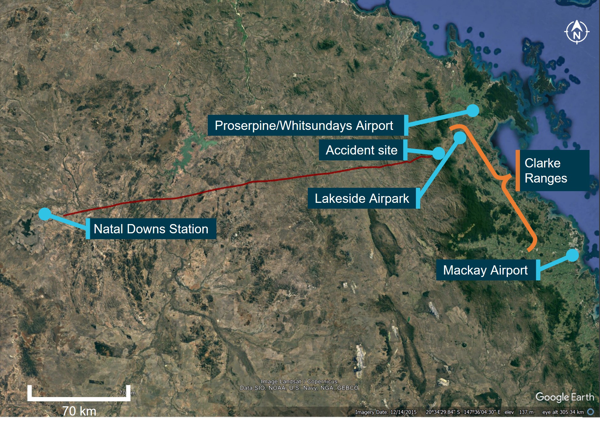
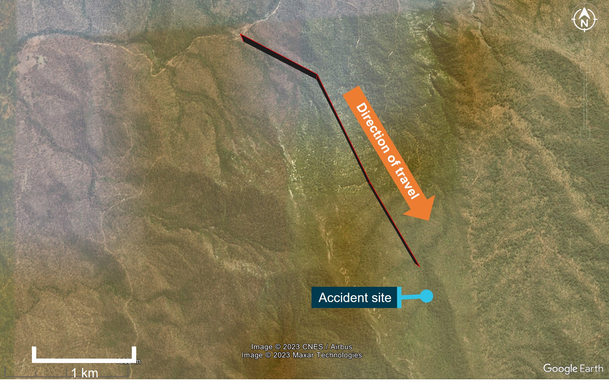
On 2 April 2023, at about 1530 local time, the pilot and passenger departed Natal Downs Station for a private flight to the Lakeside Airpark (Figure 1). The automatic dependent surveillance-broadcast data recorded the aircraft climbing to, and cruising between 6,000 ft and 6,500 ft above mean sea level while tracking easterly towards the Clarke Ranges. At about 1633, the aircraft was descended and then maintained an altitude between 2,000 ft and 2,500 ft. At about 1651, when in the vicinity of high terrain, the aircraft was turned onto a south-easterly direction for 1 minute. The final recorded position was about 250 m north-north-east of the accident site at about 2,150 ft (about 250 ft above ground level) (Figure 2).
Figure 1: Map with key locations and flight path (red)

Source: Google Earth and Airservices Australia, annotated by the ATSB
Figure 2: Last recorded flight path

Source: Google Earth, annotated by the ATSB
When the aircraft did not arrive at the Lakeside Airpark at the expected time, a search and rescue operation commenced. The following day, the aircraft wreckage was located on a steep slope at 1,913 ft. The pilot and passenger were fatally injured and the aircraft was destroyed.
Pilot information
Experience and qualifications
A review of records established that the pilot did not hold a Civil Aviation Safety Authority (CASA) aeroplane pilot’s licence (either a Recreational Pilot Licence or Private Pilot Licence) required to conduct the flight. The pilot also did not hold a Recreational Aviation Australia pilot certificate.
Records from the flying school where the pilot trained showed that they had completed 30.4 hours of flight instruction (25.4 hours dual and 5.0 hours solo) between November 2021 and November 2022. This included 2.9 hours on the Piper PA-28-180 aircraft type. During this time, the pilot completed the practical requirements to obtain a CASA recreational pilot licence but had not completed the flight or theory tests required to have the licence issued. It was reported by the flying school that the pilot intended to continue with training to attain a CASA Private Pilot’s Licence (Aeroplane), and this was the reason no testing had been completed. The training records also showed that the pilot had completed one navigation theory lesson towards this licence. No further records of flying training or other flying experience was available.
The pilot became the registered owner of VH-PXR in November 2022. The ATSB could not determine how many hours experience the pilot had in the aircraft. Information obtained by the ATSB detailed that the pilot had flown around the area around Natal Downs station in the aircraft. In addition, the automatic dependent surveillance-broadcast data recorded a previous return flight in the aircraft from Natal Downs Station to Lakeside Airpark about 1 week prior to the accident.
In suitable weather conditions, the planned flight from Natal Downs Station to Lakeside Airpark could have been flown in visual flight rules[1] conditions by a pilot holding a CASA Recreational Pilot Licence with a navigation endorsement.
Medical information
The pilot was issued with a Class 2 Aviation Medical Certificate in January 2023. The ATSB reviewed the pilot’s aviation medical records, which noted that they had previous, and ongoing medical conditions. The ATSB corresponded with CASA, who advised that they had considered this information in the issue of the pilot’s medical certificate. They had also conducted a post‑accident review of the pilot’s medical records and remained satisfied that the pilot met the requirements for the issue of the certificate.
Aircraft information
VH-PXR was a Piper Aircraft Corp PA-28-180 Cherokee aircraft, first registered in Australia in August 1968. A periodic inspection was carried out and a maintenance release issued on 24 October 2022 at 10,861.6 hours’ time-in-service. The aircraft was approved for instrument flight rules[2] operation, however, at the time of the accident it was restricted to day visual flight rules only until instrument lighting and glideslope defects were rectified.
The ATSB acquired evidence the pilot had completed maintenance on the aircraft’s pitot-static mast in February 2023 to clear blockages. They did not hold an aircraft maintenance engineer licence or authorisation to perform or certify for maintenance on the aircraft. This type of maintenance could lead to erroneous indications of the airspeed indicator, altimeter, and vertical speed indicator. It could not be determined if this contributed to the accident.
Meteorological information
The flight departed in good conditions suitable for visual flight. However, as was forecast, the conditions deteriorated as the aircraft approached the Clarke Ranges. Information from the Bureau of Meteorology for the accident area (within the Clarke Ranges) indicated that the forecast for all heights above mean sea level was:
- generally broken cloud[3] between 2,000 ft and 6,000 ft
- scattered showers of rain with broken cloud base of 1,000 ft and visibility reducing to 3,000 m
- isolated thunderstorms with bases of 1,000 ft and visibility reducing to 1,000 m.
The conditions over these ranges and toward the coast included significant low cloud, rain, and thunderstorms. All these phenomena led to reduced visibility. Immediately prior to the accident, the weather radar recorded rain in the area.
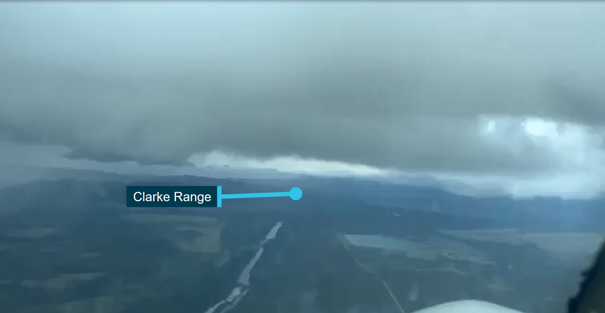
Images and video taken during the flight showed broken cloud ahead, with the base below the altitude of the aircraft. The ranges where the accident site occurred were obscured by low cloud, with rain visible (Figure 3).
Figure 3: Image taken in-flight of the weather conditions ahead

Source: Supplied
Terrain
The flight was initially conducted over the relatively flat terrain of inland Queensland, with elevations generally ranging between 500 ft and 1,500 ft. The Clarke Range separated the inland areas from the low and flat coastal plains near the destination, Lakeside Airpark, for about 55 km along the intended route. Within the Clarke Range, the topography was substantially more rugged and elevated than the coastal or inland areas, rising in excess of 3,200 ft. The accident occurred within this area at an elevation of 1,913 ft.
Site and wreckage information
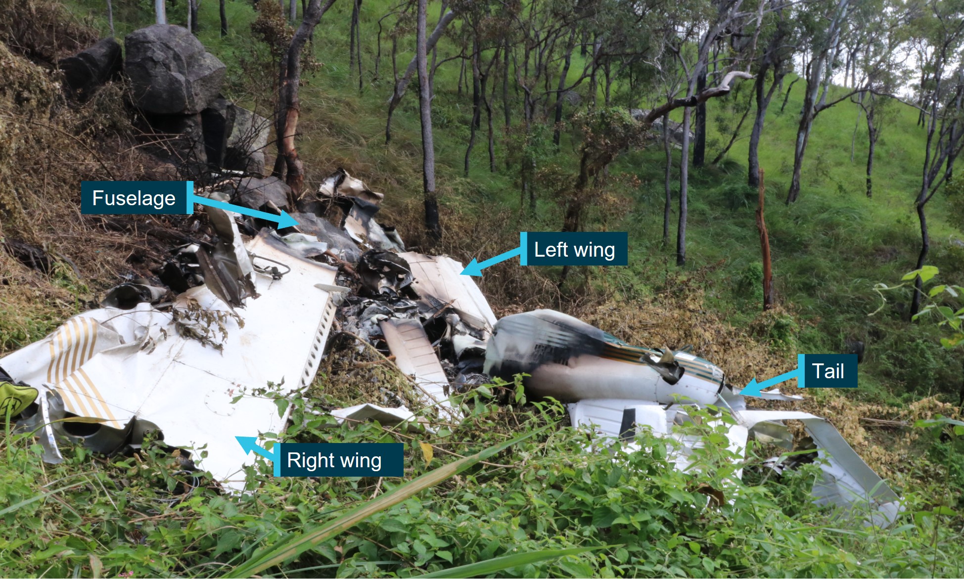
Due to the terrain, the ATSB did not attend the accident site. However, photographs and videos were obtained from Queensland Police and the Australian Maritime Safety Authority Joint Research Co-ordination Centre, and examined by the ATSB (Figure 4). Observations of the accident site included:
- About 80 m prior to the wreckage, a number of trees sustained damage. This damage was shown to have an increasing angle down towards the wreckage.
- The aircraft collided with terrain on a steep slope, and the wreckage was observed to be inverted. It was unknown if the aircraft collided with terrain inverted or became inverted during the accident sequence.
- There was minimal spread of the wreckage, and the wings, fuselage, and tail were in their expected positions relative to the structure of the aircraft.
- The leading edge of the right wing sustained damage consistent with a tree strike.
- The forward fuselage was destroyed by fire.
- The propeller was found intact, and showed impact marks and bending consistent with the engine producing power at the time of impact.
Consideration of these factors suggested that an in-flight break-up, engine failure or fuel exhaustion were unlikely to be contributory to the accident. The relatively contained wreckage was representative of a low speed, high angle of attack impact with the ground.
Figure 4: Aircraft wreckage

Source: Queensland Police Service
Safety message
This accident highlights the importance of following the standards for the operation and maintenance of aircraft to ensure the safety of flight. It further demonstrates that weather continues to remain one of the most significant causes of accidents in general aviation. The often‑fatal outcomes of these accidents are usually all the more tragic as they are avoidable. Despite the dangers of visual flight rules pilots flying into instrument meteorological conditions being well recognised, this continues to be a recurring factor in aircraft accidents and has been the focus of numerous previous ATSB reports and publications.
The ATSB publication Avoidable Accidents No. 4, Accidents involving Visual Flight Rules Pilots (VFR) in instrument Meteorological Conditions (IMC) found that weather alone is never the only factor affecting pilot decisions that result in these events. Investigations consistently highlight that conducting thorough pre-flight planning is the best defence against flying into deteriorating weather. The ATSB encourage all pilots, no matter what their experience level, to develop the knowledge and skills required to avoid unintentional operations into adverse weather. This could be aided by having alternate plans in case of unexpected changes in weather, making timely decisions to turn back, divert or hold in an area of good weather, and using a ‘personal minimums’ checklist to help clearly identify risk factors.
Reasons for the discontinuation
The Civil Aviation Safety Authority have put in place regulations designed to ensure pilots are properly trained and qualified to manage challenges likely to be encountered during flying operations. This includes training intended to teach pilots to identify and manage situations presented by adverse weather, both at the pre-flight planning phase and during flight. However, when pilots operate outside these rules, they remove the built-in safety defences. On that basis, the ATSB determined that there was limited safety benefit in continuing to direct resources at this investigation when compared with other priorities and elected to discontinue this investigation.
[1] Visual flight rules (VFR): a set of regulations that permit a pilot to operate an aircraft only in weather conditions generally clear enough to allow the pilot to see where the aircraft is going.
[2] Instrument flight rules (IFR): a set of regulations that permit the pilot to operate an aircraft in instrument meteorological conditions (IMC), which have much lower weather minimums than visual flight rules (VFR). Procedures and training are significantly more complex as a pilot must demonstrate competency in IMC conditions while controlling the aircraft solely by reference to instruments. IFR-capable aircraft have greater equipment and maintenance requirements.
[3] Cloud cover: in aviation, cloud cover is reported using words that denote the extent of the cover – ‘broken’ indicates that more than half to almost all the sky was covered.


