Preliminary report released 31 August 2022
This preliminary report details factual information established in the investigation’s early evidence collection phase and has been prepared to provide timely information to the industry and public. Preliminary reports contain no analysis or findings, which will be detailed in the investigation’s final report. The information contained in this preliminary report is released in accordance with section 25 of the Transport Safety Investigation Act 2003.
The occurrence
Introduction
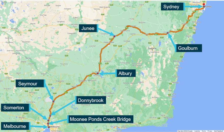
On 23 May 2022, the XPT passenger train ST21 departed Central Station in Sydney, New South Wales at about 2039,[1] on a scheduled service to Southern Cross Station in Melbourne, Victoria via Goulburn, Junee and Albury (Figure 1). The train was operating on the interstate standard gauge track[2] between Sydney and Melbourne. On board were the driver, four passenger services crew and 57 passengers.
Figure 1: Standard gauge rail route from Sydney to Melbourne

Source: Google Maps with annotations by the Chief Investigator, Transport Safety
At about 2121 that same evening, the driver of a V/Line train reported rough track at about the 24.2 km[3] location at the Moonee Ponds Creek Bridge, in the Local Government Area of Moreland. The report was made to the Australian Rail Track Corporation (ARTC) Network Control at Mile End,[4] in South Australia. In response, ARTC placed a temporary speed restriction (TSR) over that portion of the track, from 24.0 to 24.4 km.
Passage of XPT passenger train ST21
ST21 travelled from Sydney to Junee without incident, arriving at Junee at about 0228 on 24 May. Following a change of driver, the train departed at 0233. ST21 then made a scheduled stop at Albury at 0407 for about six minutes, before resuming its travel to Melbourne. At about 0605, while passing Seymour in Victoria, the Mile End Network Control Officer (NCO) responsible for the section south of Somerton, that contained the Moonee Ponds Creek Bridge, called the driver by network radio. In this call, they advised the driver of train ST21 that there was a Condition Affecting Network (CAN) warning between Somerton and Tullamarine. The driver replied that they would contact the NCO when the train was closer to that location.
At 0641, ST21 stopped at signal ES376 at Donnybrook and the driver called the responsible Mile End NCO for details of the CAN warning. The driver was informed that there was a TSR in place between the 24.000 km and 24.400 km locations and that there were no signs erected. This exchange involved the driver of ST21 transcribing the verbal advice from the NCO onto their CAN form and reading it back. At 0644 the NCO confirmed that the driver’s read-back was correct and soon after ST21 resumed its travel towards Melbourne. During this radio exchange between the driver and NCO and the issuing of the CAN warning, the line section affected was not discussed.
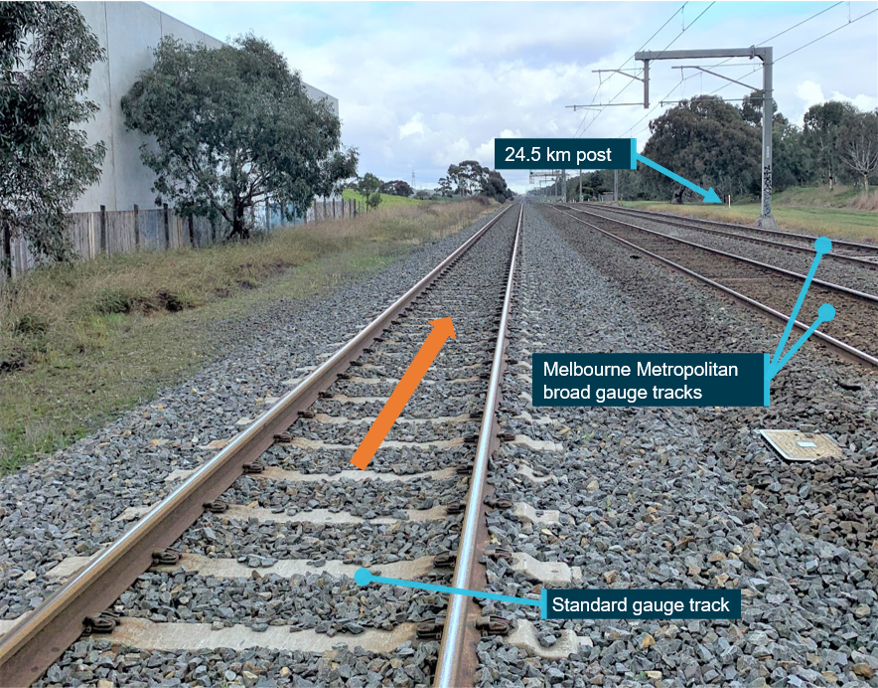
After departing Donnybrook, ST21 arrived at the 24.4 km location (north of Somerton) at about 0653. The driver reduced the train’s speed to just under 40 km/h and after passing the 24.0 km mark resumed normal speed. In this section, the standard gauge track on which ST21 was travelling was a single bi-directional track that runs parallel to and on the east side of the two Melbourne metropolitan broad gauge tracks (Figure 2).
Figure 2: Looking towards 24.4 to 24.0 km location where ST21 reduced speed.

Source: Chief Investigator, Transport Safety
The train continued its journey and entered the Mile End Network Control territory at 0656 when it passed signal SOM4[5] located at about the 21.8 km mark. At about 0658, ST21 made a scheduled two-minute stop at Broadmeadows station. The train then departed Broadmeadows station with about 50 passengers and travelled towards Jacana Junction.
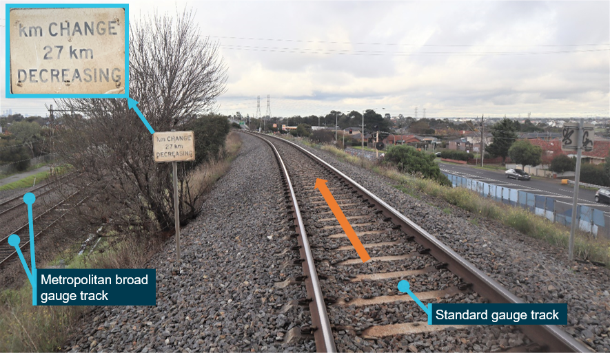
The train travelled via the Jacana flyover that passed over the broad gauge tracks. On the flyover, kilometrage marking on the standard gauge line changed from 16 km to 27 km, and from this point decreased heading towards Melbourne (Figure 3). [6]
Figure 3: Kilometre change signboard after track passed over the broad gauge lines

The figure shows the standard-gauge track a short distance after it had passed over the broad gauge tracks (at the Jacana Flyover)
Source: Chief Investigator, Transport Safety
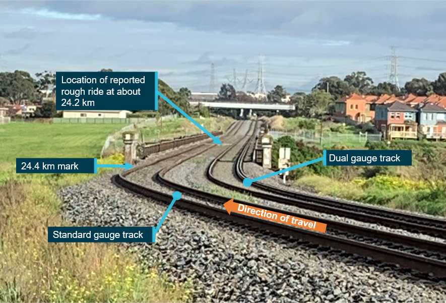
After clearing the flyover, the train’s speed was increased and at about 0703 ST21 approached the Moonee Ponds Creek Bridge at about 100 km/h. The train speed was not reduced, and the train passed over the bridge and across the rough track location. The 24.4 km mark was at the east end of the bridge, the rough track was at around the 24.2 km mark, just past midway on the bridge, and the 24.0 km mark was just past the west end of the bridge (Figure 4).[7]
Figure 4: Moonee Ponds Creek Bridge, looking west towards Melbourne

The figure shows the two tracks that crossed the Moonee Ponds Creek Bridge. ST21 was travelling on the standard gauge track.
Source: Chief Investigator, Transport Safety
At about 0705, ST21 approached the 21 km post. The driver noticed this km post and realised that the CAN warning for reduced speed may have referred to the section of track across the Moonee Ponds Creek Bridge, and not to the earlier section where they had reduced speed.
The driver of ST21 called the Mile End Network Control to clarify the correct location of the TSR and reported that they had reduced speed at the 24.4 km mark before Somerton.
The train continued to Southern Cross Station and arrived at 0831.
Context
Track information
The XPT service was operating on the interstate standard gauge track from Sydney to Melbourne. The track was part of the Defined Interstate Rail Network (DIRN) and was managed by the Australian Rail Track Corporation (ARTC).
For trains travelling toward Melbourne, the standard and broad gauge tracks ran parallel approaching Jacana before taking divergent routes. The standard gauge track crossed over the broad gauge at the Jacana Flyover and was routed via western Melbourne, whereas the broad gauge lines continued in a more direct route towards Melbourne (Figure 5). The standard gauge route between Jacana and Melbourne was about 27 km and the broad gauge route about 16 km.
Figure 5: Broad gauge and standard gauge routes to and from Melbourne

Source: Google Maps with annotations by the Chief Investigator, Transport Safety
To accommodate the longer standard gauge distance between Jacana and Melbourne, the standard gauge track included a step change in its kilometrage at the 27 km mark, measured from Southern Cross Station. For standard gauge trains travelling toward Melbourne, the kilometrage changed from 16 km to 27 km. This kilometrage change occurred on the Jacana Flyover and was sign posted (Figure 3).
As a result of this kilometrage change point, standard gauge trains travelling toward Melbourne would encounter the kilometrage marks between 27 and 16 km twice, on either side of the Jacana Flyover kilometrage change point.
Network control
Rail traffic on the ARTC network was managed from ARTC network control centres. Network Control Officers (NCO) located within the centres were responsible for the movement of trains and track vehicles in accordance with ARTC Safe Working Rules and Procedures.
Network control centres were assigned different regions. For the Sydney to Melbourne standard gauge route, the ARTC control centre in Junee managed the movement of trains between Sydney and Somerton signal SOM4, located about 21.8 rail-km from Melbourne. South of this signal, the Mile End control centre in South Australia was responsible for rail traffic. The NCO on the Melbourne Metro Network Control Board at Mile End covered the area from Somerton to Moonee Ponds Creek, Appleton Dock and North Dynon.
Junee Network Control was responsible for the control of signal SOM4, and required clearance from the NCO on the Mile End Melbourne Metro Network Control Board before releasing a train into the region controlled by Mile End Network Control.
The Condition Affecting Network (CAN) warning
In accordance with the ARTC Code of Practice, a Condition Affecting the Network (CAN) form was required to provide written warning to rail traffic when there was a temporary speed restriction and no signs erected.[8] The NCO responsible for the section was required to arrange for train crew to receive the CAN warning before they entered the affected portion of track, and dictate the CAN warning details to the crew. The train crew was required to acknowledge the CAN warning and in the case of a temporary speed restriction, proceed through the affected section at no greater than the specified reduced speed.
In this instance, the Condition Affecting the Network (CAN) warning was initiated following a report of rough track by the driver of a V/Line train, at 2121 the previous evening. ARTC placed a temporary speed restriction of 40 km/h at the location of rough track. The TSR was withdrawn at 0836 on 24 May after completion of works at the location.
Weather and visibility
On this day, civil twilight commenced at 0652 and sunrise was at 0721. There was no rain at the time and the visibility was clear.
Further investigation
To date, the ATSB has:
- inspected the location of the occurrence
- examined train operational information
- examined radio communications between driver and network control
- examined train control records
- interviewed relevant parties
- commenced collection of relevant procedural documentation
The investigation is continuing and will include further review and investigation of:
- the track condition that led to the temporary speed restriction (TSR)
- the operation of the train, including the circumstances that led to ST21 traversing Moonee Ponds Creek Bridge at a speed exceeding the TSR
- the processes and risk controls associated with the establishment of a temporary speed restriction and its communication to drivers
Should a critical safety issue be identified during the course of the investigation, the ATSB will immediately notify relevant parties so appropriate and timely safety action can be taken.
A final report will be released at the conclusion of the investigation.
Australian Transport Safety BureauAbout the ATSBThe ATSB is an independent Commonwealth Government statutory agency. It is governed by a Commission and is entirely separate from transport regulators, policy makers and service providers. The ATSB’s purpose is to improve the safety of, and public confidence in, aviation, rail and marine transport through:
The ATSB is responsible for investigating accidents and other transport safety matters involving civil aviation, marine and rail operations in Australia, as well as participating in overseas investigations involving Australian-registered aircraft and ships. It prioritises investigations that have the potential to deliver the greatest public benefit through improvements to transport safety. The ATSB performs its functions in accordance with the provisions of the Transport Safety Investigation Act 2003 and Regulations and, where applicable, international agreements. Rail safety investigations in VictoriaMost transport safety investigations into rail accidents and incidents in Victoria and New South Wales (NSW) are conducted in accordance with the Collaboration Agreement for Rail Safety Investigations and Other Matters between the Commonwealth Government of Australia, the State Government of Victoria, and the State Government of New South Wales. Under the Collaboration Agreement, rail safety investigations are conducted and resourced in Victoria by the Chief Investigator, Transport Safety (CITS) and in New South Wales by the Office of Transport Safety Investigations (OTSI), on behalf of the ATSB, under the provisions of the Transport Safety Investigation Act 2003. The Chief Investigator, Transport Safety (CITS) is a statutory position established in 2006 to conduct independent, no-blame investigation of transport safety matters in Victoria. CITS has a broad safety remit that includes the investigation of rail (including tram), marine and bus incidents. Purpose of safety investigationsThe objective of a safety investigation is to enhance transport safety. This is done through:
It is not a function of the ATSB to apportion blame or provide a means for determining liability. At the same time, an investigation report must include factual material of sufficient weight to support the analysis and findings. At all times the ATSB endeavours to balance the use of material that could imply adverse comment with the need to properly explain what happened, and why, in a fair and unbiased manner. The ATSB does not investigate for the purpose of taking administrative, regulatory or criminal action. TerminologyAn explanation of terminology used in ATSB investigation reports is available on the ATSB website. This includes terms such as occurrence, contributing factor, other factor that increased risk, and safety issue. |
[1] All times stated are in Australian Eastern Standard Time (AEST). All arrival and departure times at stations are from the NSW Trains Timetable Report.
[2] Referred to as the Defined Interstate Rail Network (DIRN).
[3] Measured from Southern Cross Station, Melbourne.
[4] ARTC Network Control Centre West, Mile End, that was responsible for traffic control south of Somerton. This area included the section containing Moonee Ponds Creek Bridge.
[5] On passing this signal, control for ST21 transferred from the Junee to the Mile End Network Control.
[6] There was a step change in kilometrage at this point in the standard gauge track because its distance to Melbourne was 11 km longer than the broad gauge route. The change occurred on the Jacana Flyover, a short distance beyond the bridge where the standard gauge track passed over the broad gauge.
[7] The Moonee Ponds Creek Bridge was approximately 350 m long and extended from 24.40 km to 24.05 km marks.
[8] TA20 – ARTC Code of Practice for the Victorian Main Line Operations, Section 6d, Warning Rail Traffic


