
What happened
At about 0845 Western Standard Time[1] on the 16 September 2018, a Cessna 207, registered VH-MIA (MIA), operated by Kalbarri Scenic Flights, took off to conduct a scenic flight from Kalbarri, West Australia (WA), to East Wallabi Island, WA. A pilot and three passengers were on board the aircraft.
The pilot had conducted a short scenic flight lasting about 45 minutes earlier that morning. She had around 30 minutes between flights to prepare the aircraft for the second flight.
The pilot advised that she briefed the passengers on the safety aspects of the aircraft before taking off. The flight proceeded past the township of Kalbarri and then along the shoreline before heading to East Wallabi Island, part of the Abrolhos Islands, at about 2,500 ft above mean sea level.
The aircraft overflew the island and the pilot reported that she observed the windsock was indicating an easterly wind, which was a crosswind for both runways. She decided to join runway 36 on the mid-crosswind leg of the circuit. The pilot reported that she touched down on the runway abeam the taxiway (see Figure 2), which normally gives her enough runway length to stop the aircraft. However, on this occasion, she could not stop the aircraft and overran the runway end by approximately 1 metre (Figure 1). The aircraft was not damaged and there were no injuries to the pilot or passengers.
Figure 1: VH-MIA after runway excursion
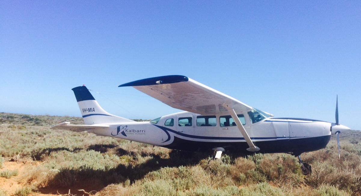
Source: Sue McAuliffe
Runway strip
The runway strip on East Wallabi Island is a privately owned unsealed strip. It is 637 m long and 30 m wide. The pilot reported that it slopes down slightly in the middle and has soft sand at one end. The windsock is on the western side of the runway on a slight hill.
Figure 2: East Wallabi Island runway and Kalbarri, North Island and East Wallabi Island
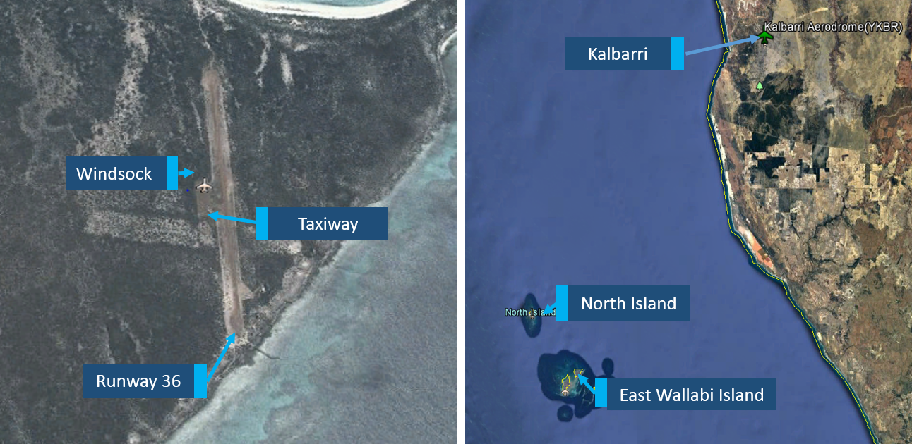
Source: Google Earth, annotated by ATSB
Weather at East Wallabi Island
East Wallabi Island does not have a dedicated weather forecasting service, but weather observations from North Island, which is 20 km north-west of East Wallabi Island, indicated that the wind was from the south at approximately 8 knots. This would indicate that the wind was almost all tailwind at the time the aircraft landed.
Pilot comments
The pilot reported she had checked the weather before they had departed on the first flight that morning.
The pilot reported that the approach and landing appeared normal until the aircraft did not slow after the aircraft touched down on the runway. She had slowed the aircraft to 80 kts on the final leg of the approach and touched down at the normal speed. She applied brakes as normal, released and then reapplied the brakes, to ensure the wheels did not lock, as this was a gravel strip.
The pilot reported that she used the position of the taxiway along the runway as her decision point as to whether she was going to conduct a go-around. As everything felt normal at that stage, she did not conduct a go-around.
The pilot reported that she was not fatigued. She had a day off the day before the incident. She had slept normally and had risen at her normal time of around 0530. She had arrived at the airport at around 0700, which gave her plenty of time to prepare for the flights. She was not feeling time pressure and the workload for the flight was normal.
She also advised that she had flown to the island a number of times and knew the strip well.
Operator comments
The operator reported that the aircraft was loaded within the aircraft limits.
The operator has discussed the incident with the pilot. They have stressed the importance of checking the windsock on the final leg of the circuit to ensure there is no downwind component, especially on a short runway. The operator and the pilot have also discussed the importance of using all available weather data, in particular the observations page on the Bureau of Meteorology website before going flying.
Previous occurrences
A review of the ATSB occurrence database for similar occurrences identified that in the last 10 years there were 14 incidents where a tailwind contributed to a runway excursion on landing. Of these, 11 were excursions where the aircraft ran off the end of the runway. Seven of these aircraft sustained substantial damaged.
Safety analysis
While the pilot advised she had checked the wind as they overflew the runway to join the circuit for runway 36, weather information received from the Bureau of Meteorology indicated that there was a southerly wind at the time the aircraft landed. The ATSB could not clarify if the pilot misread the windsock or the wind direction had momentarily changed when they joined the circuit and returned back to the southerly direction before the aircraft landed. The aircraft most likely landed with a tail wind component resulting in a faster ground speed at touchdown and the aircraft overrunning the end of the runway.
The pilot’s decision to land the aircraft adjacent to the taxiway reduced the available stopping distance available. Using the full runway strip, would probably have allowed the pilot to stop the aircraft on the runway.
Findings
These findings should not be read as apportioning blame or liability to any particular organisation or individual.
- It is likely that the aircraft landed with a tailwind component resulting in the aircraft overrunning the runway.
- The pilot’s chosen landing position did not use the full runway strip length, reducing the stopping distance available.
Safety message
This incident highlights the importance of, where possible, landing with a headwind. Landing with a tailwind could result in an increase in the required landing distance by 21 per cent for the first 10 kts of tailwind, according to the United States’ Federal Aviation Administration advisory circular no. 91-79A Mitigating the risks of a runway overrun upon landing. They also advise that for some smaller general aviation aircraft (for example a Cessna 152), the landing distance required will increase by 10 per cent for every 2 kts of tailwind. If a pilot is not expecting a tailwind component, there is a significant risk that the aircraft will overrun the runway when operating on a short runway. One way of reducing the chances of landing with a tailwind is to include a check of the windsock during pre-landing checks and to conduct a go-around if a tailwind is detected.
Runway excursions continue to be a safety concern around the world with the Transport Safety Board of Canada recently releasing its Watchlist 2018, which lists runway overruns as one of its two aviation safety concerns for 2018.
Purpose of safety investigationsThe objective of a safety investigation is to enhance transport safety. This is done through:
It is not a function of the ATSB to apportion blame or provide a means for determining liability. At the same time, an investigation report must include factual material of sufficient weight to support the analysis and findings. At all times the ATSB endeavours to balance the use of material that could imply adverse comment with the need to properly explain what happened, and why, in a fair and unbiased manner. The ATSB does not investigate for the purpose of taking administrative, regulatory or criminal action. TerminologyAn explanation of terminology used in ATSB investigation reports is available here. This includes terms such as occurrence, contributing factor, other factor that increased risk, and safety issue. Publishing informationReleased in accordance with section 25 of the Transport Safety Investigation Act 2003 Published by: Australian Transport Safety Bureau © Commonwealth of Australia 2019
Ownership of intellectual property rights in this publication Unless otherwise noted, copyright (and any other intellectual property rights, if any) in this report publication is owned by the Commonwealth of Australia. Creative Commons licence With the exception of the Coat of Arms, ATSB logo, and photos and graphics in which a third party holds copyright, this publication is licensed under a Creative Commons Attribution 3.0 Australia licence. Creative Commons Attribution 3.0 Australia Licence is a standard form licence agreement that allows you to copy, distribute, transmit and adapt this publication provided that you attribute the work. The ATSB’s preference is that you attribute this publication (and any material sourced from it) using the following wording: Source: Australian Transport Safety Bureau Copyright in material obtained from other agencies, private individuals or organisations, belongs to those agencies, individuals or organisations. Where you wish to use their material, you will need to contact them directly. |
__________