What happened
On 12 February 2017, a Boeing 747-47UF (freighter) aircraft, registered N416MC, operating from Honolulu, Hawaii, conducted an approach to Sydney Airport, New South Wales. On board the aircraft were two flight crew. The captain was the pilot monitoring (PM) and the first officer was the pilot flying (PF).[1]
The aircraft was cleared by the approach controller for the runway 16R instrument landing system (ILS) approach.[2] The autopilot was engaged[3] and the modes for localiser and approach (glideslope) were armed[4] while the aircraft was flown at 2,200 ft on a heading of 200° to intercept the 16R ILS. The aircraft captured[5] the localiser and the PF turned it left onto the 16R final approach course, while maintaining 2,200 ft, in order to intercept the glideslope from below.
Shortly after the turn onto the final approach, the PF called ‘glideslope captured’ and the aircraft started to descend. However, the PM’s primary flight display[6] was still showing the aircraft below the glideslope. The PM crosschecked the PF’s display and noticed the glideslope was captured, then checked their own display and noticed there was a failure flag displayed for the glideslope. The PM again crosschecked the PF’s display, noticed there was a failure flag for the PF’s glideslope, and instructed the PF to disconnect the autopilot and stop the descent.
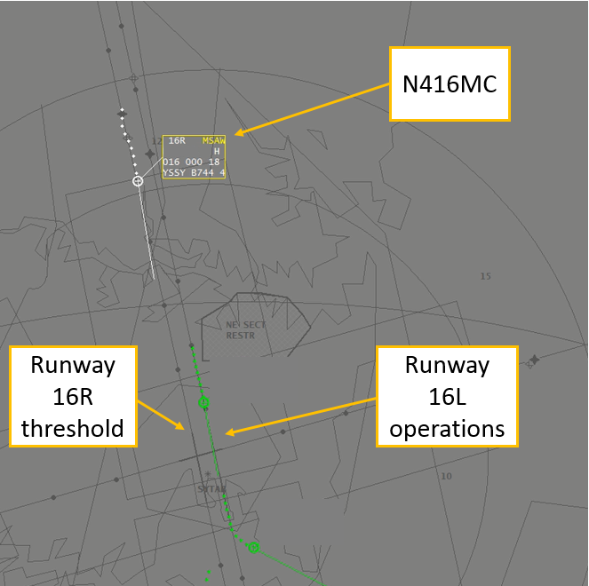
As the aircraft descended through 2,100 ft, the approach controller requested confirmation that they were established on the glideslope. The PM responded that they had an interruption on glideslope and would maintain altitude until they could re-intercept. During the response, a minimum safe altitude warning (MSAW) alert appeared on the approach controller’s radar for N416MC at an altitude of 1,800 ft. The approach controller immediately issued the instruction ‘go-around, you are well below the glide-path, go-around’. The PM immediately acknowledged the instruction, and the flight crew initiated the missed approach procedure.
The lowest point on the approach was 1,559 ft from flight data (1,600 ft on radar) at about 8.0 NM (14.8 km) from runway 16R (Figure 1). This resulted in the aircraft descending about 1,000 ft below the nominal 3° glideslope at the time of the incident. The aircraft was flown on the second approach with autopilot engaged. The localiser and glideslope captured and tracked the ILS with no anomalies detected.
Figure 1: Minimum safe altitude warning for N416MC
Source: Airservices, annotated by the ATSB
ILS signal interference
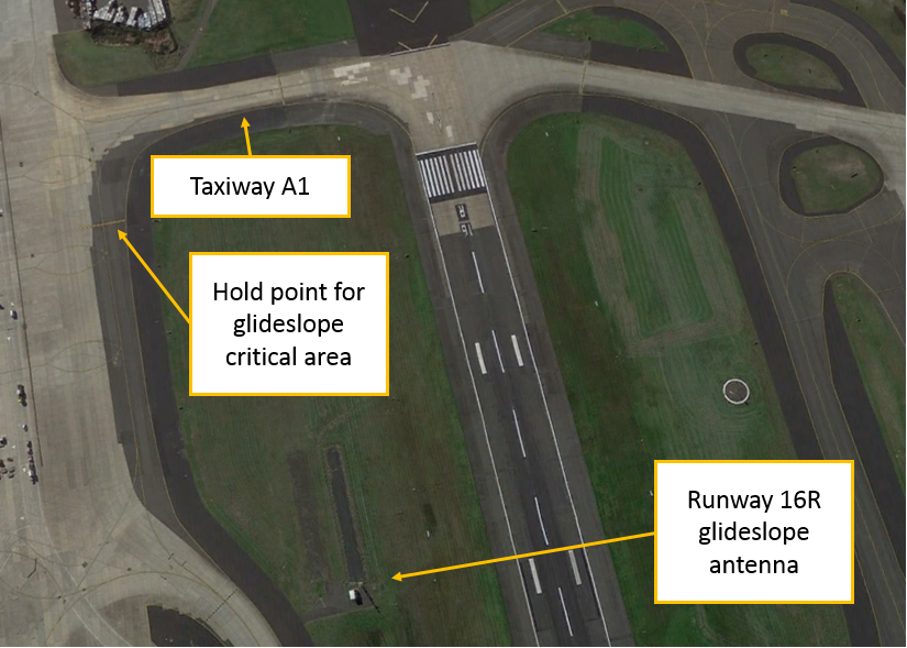
Disturbances to ILS localiser and glideslope courses are caused by fixed structures, such as buildings (static distortion), and moving vehicles or aircraft (dynamic distortion). The total ILS course distortion is determined by the root square summation of static and dynamic distortion, and this is used to define critical areas[7] near each localiser and glideslope antenna (Figure 2).
Figure 2: Runway 16R glideslope antenna and critical area hold point
Source: Google earth, annotated by the ATSB
The critical areas are protected for low visibility approaches. This is when the cloud ceiling is at or below 600 ft, or the visibility is 2000 m or less. In which case, no aircraft or vehicle is permitted to enter the critical areas when an arriving aircraft is within the outer marker, or 4 NM from the threshold if there is no outer marker.
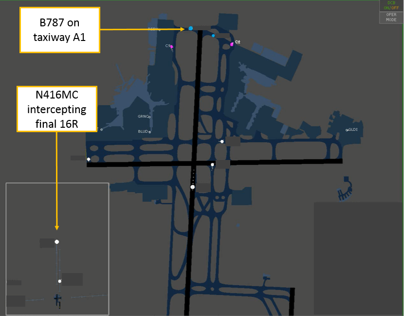
At the time N416MC intercepted the runway 16R localiser, a Boeing 787 was holding on taxiway A1, within the runway 16R glideslope critical area (Figure 3). However, the weather conditions did not require air traffic control to activate the ILS critical area, and N416MC was instructed to go‑around before reaching the outer marker.[8]
Figure 3: Infringement of the 16R glideslope critical area
Source: Airservices, annotated by the ATSB
Receiver characteristics
A moving receiver passing through a distorted ILS signal will produce a guidance error. The error produced will vary depending on the receiver characteristics, its antenna characteristics and the speed of the vehicle carrying the receiver as it passes through the distorted signal.
Similar incidents
Glideslope signal disturbances
- On 17 March 2017, a Boeing 747-400 attempted to intercept the runway 16R ILS in instrument meteorological conditions using the autopilot for a coupled approach.[9] When the glideslope was captured, the indications began to oscillate, and the autopilot chased the indications. A high rate of descent developed and a ‘low on profile’ call was made on the flight deck to stop the descent. The descent was stopped at about 1,500 ft, about 7 NM (13 km) from the threshold of runway 16R. An Airbus A380 was lined up for departure on runway 16R from taxiway A1 when the Boeing 747 was about 8 NM (14.8 km) from the threshold of runway 16R.
- On 23 March 2017, a Boeing 747-400 attempted to intercept the runway 16R ILS in instrument meteorological conditions using the autopilot for a coupled approach. Approaching 2,000 ft, the glideslope on the captain’s primary flight display disappeared, followed by the glideslope on the first officer’s primary flight display. The aircraft pitched nose down with an associated increased rate of descent. The captain disengaged the autopilot and stopped the descent at about 1,500 ft and 8 NM (14.8 km) on final for 16R. A minimum safety altitude alert activated, and the approach controller instructed the flight crew to conduct a missed approach. An Airbus A380 was holding on taxiway A1 at the time of the incident. A second approach was flown using the autopilot without incident. There were no aircraft in the glideslope critical area during the second approach.
Localiser signal disturbance
On 27 August 2015, a Boeing 787-800 attempted to conduct an autoland[10] to runway 34L at Sydney Airport in visual meteorological conditions. The aircraft experienced a disturbance to the localiser signal at about 100 ft and the flight crew immediately disconnected the autopilot to complete the landing. The flight crew were aware the ILS critical area was not required to be protected at the time and had not notified air traffic control they were conducting an autoland. They were aware that disturbances to the ILS signals were possible and were prepared to intervene. An Airbus A330 departed directly in front of the 34L localiser antenna at the time of the incident.
Manufacturer comments
Boeing, the aircraft manufacturer, reported that they have no reason to believe that the 747 would behave any differently to their other aircraft types. The same antenna system is installed on the 757, 767 and 777. However, there are some differences in the antenna locations. The 747 and 777 receiver antennas are located on the main landing gear doors, while the 757 and 767 antennas are located in the nose of the aircraft. The glideslope incidents might relate to a varying signal strength, rather than a distorted beam.
Aeronautical Information Publication
If a pilot advises air traffic control that an ‘autoland’ or ‘coupled approach’ is to be flown, then air traffic control will either report ‘ILS critical area not protected’ or ‘LVP[11] in force’ if the critical area is protected.[12]
Airservices Australia comments
Airservices Australia, the air traffic services provider, reported that disturbance of the glideslope signal is less for aircraft at the taxiway A holding point (holding point for glideslope critical area) than it is for the same aircraft at the holding point on taxiway A1. Airservices Australia conducted a computer simulation which indicated that an Airbus A380 aircraft stationary at holding point A1 is unlikely to have caused the large ILS signal disturbance observed in this incident.
The simulations and radar recordings indicated the observed disturbance in each case occurred after the holding aircraft was provided with its line up clearance and while taxiing between the holding point and the runway. In this respect, there will always be significant interference to approaching aircraft outside 4 NM regardless of whether the holding point on taxiway A or A1 is used at the same time as runway 16R is used for arrivals.
Safety analysis
N416MC intercepted the final approach, and the autopilot captured the ILS localiser and glideslope at the same time as a Boeing 787 (B787) was holding on taxiway A1, which lies within the critical area for the runway 16R glideslope. The presence of the 787 in the critical area likely resulted in N416MC receiving either a distorted glideslope beam or a beam of varying signal strength. This required flight crew intervention following a glideslope failure indication, which was detected by the captain crosschecking the two primary flight displays. At the time of the incident, the glideslope critical area was not required to be protected, in accordance with the manual of air traffic services.
ATSB comment
It has been previously noted by regulators and manufacturers, that it is common practice for operators to conduct coupled approaches and autoland to satisfy maintenance, training or reliability program requirements. These approaches may be conducted in weather conditions which do not require protection of the ILS signal. There have been incidents reported in which the autopilot has responded to disturbances in the ILS signal when the aircraft was close to landing. Airservices Australia advise that ILS signals may be disturbed with the consequential effect on autoland performance when weather conditions do not require protection of the ILS critical area.
For more information on ILS signal distortion and determination of protected areas following the introduction of the Airbus A380 see Assessment of ILS protection areas impact on large aircraft operations.
Findings
These findings should not be read as apportioning blame or liability to any particular organisation or individual.
- The descent below the nominal 3° approach glideslope was probably the result of the aircraft auto-pilot capturing a distorted glideslope beam.
- The glideslope beam was probably distorted due to the presence of a Boeing 787 in the glideslope critical area, which was not required to be protected in the weather conditions which prevailed at the time of the incident.
Safety message
This incident highlights the importance of crosschecks on the flight deck and between air traffic control and the flight crew. After detecting unexpected indications on the flight deck, the flight crew intervened to stop the descent, which was then followed by an instruction from air traffic control to initiate a go-around.
The aircraft manufacturer and regulators have recommended that flight crew remain vigilant for ILS disturbances with resulting unexpected flight control movements and be prepared to immediately disconnect the autopilot, particularly during autoland operations.
Aviation Short Investigations Bulletin Issue 61
Purpose of safety investigationsThe objective of a safety investigation is to enhance transport safety. This is done through:
It is not a function of the ATSB to apportion blame or provide a means for determining liability. At the same time, an investigation report must include factual material of sufficient weight to support the analysis and findings. At all times the ATSB endeavours to balance the use of material that could imply adverse comment with the need to properly explain what happened, and why, in a fair and unbiased manner. The ATSB does not investigate for the purpose of taking administrative, regulatory or criminal action. TerminologyAn explanation of terminology used in ATSB investigation reports is available here. This includes terms such as occurrence, contributing factor, other factor that increased risk, and safety issue. Publishing informationReleased in accordance with section 25 of the Transport Safety Investigation Act 2003 Published by: Australian Transport Safety Bureau © Commonwealth of Australia 2017
Ownership of intellectual property rights in this publication Unless otherwise noted, copyright (and any other intellectual property rights, if any) in this report publication is owned by the Commonwealth of Australia. Creative Commons licence With the exception of the Coat of Arms, ATSB logo, and photos and graphics in which a third party holds copyright, this publication is licensed under a Creative Commons Attribution 3.0 Australia licence. Creative Commons Attribution 3.0 Australia Licence is a standard form licence agreement that allows you to copy, distribute, transmit and adapt this publication provided that you attribute the work. The ATSB’s preference is that you attribute this publication (and any material sourced from it) using the following wording: Source: Australian Transport Safety Bureau Copyright in material obtained from other agencies, private individuals or organisations, belongs to those agencies, individuals or organisations. Where you wish to use their material, you will need to contact them directly. |
__________
- Pilot Flying (PF) and Pilot Monitoring (PM): procedurally assigned roles with specifically assigned duties at specific stages of a flight. The PF does most of the flying, except in defined circumstances; such as planning for descent, approach and landing. The PM carries out support duties and monitors the PF’s actions and the aircraft’s flight path.
- The instrument landing system is a ground-based precision approach and landing aid. The main elements are (1) the localiser antenna, which provides centreline guidance; (2) the glideslope antenna, which provides a nominal 3° descent guidance; (3) the marker beacons (outer, middle and inner), which are used for altimetry checks and to indicate what stage of the approach has been reached; and (4) the approach lights (Distance Measuring Equipment (DME) and Global Navigation Satellite System (GNSS) may be used in lieu of marker beacons).
- Engaged: A system mode or function that is actively performing its function.
- Armed: A system mode or function that is set to become actively engaged at a later time, when certain conditions are met.
- Captured: A system mode has become engaged.
- An electronic flight display that presents the primary flight instruments, navigation instruments, and other information about the status of the flight in one integrated presentation.
- The critical area is a volume of airspace encompassing lateral and vertical dimensions based around the localiser and glideslope antennas to protect the ILS signal transmissions to airborne aircraft in poor weather.
- Runway 16R outer marker is about 3.9 NM from the runway threshold.
- Coupled approach: An approach flown by the auto-pilot.
- Landing of the aircraft by the autopilot for the operational purpose of landing when there are no visual cues for the pilot.
- Low visibility procedures
- Refer: Aeronautical Information Publication (AIP) Australia AD 1.1 – 2.


