What happened
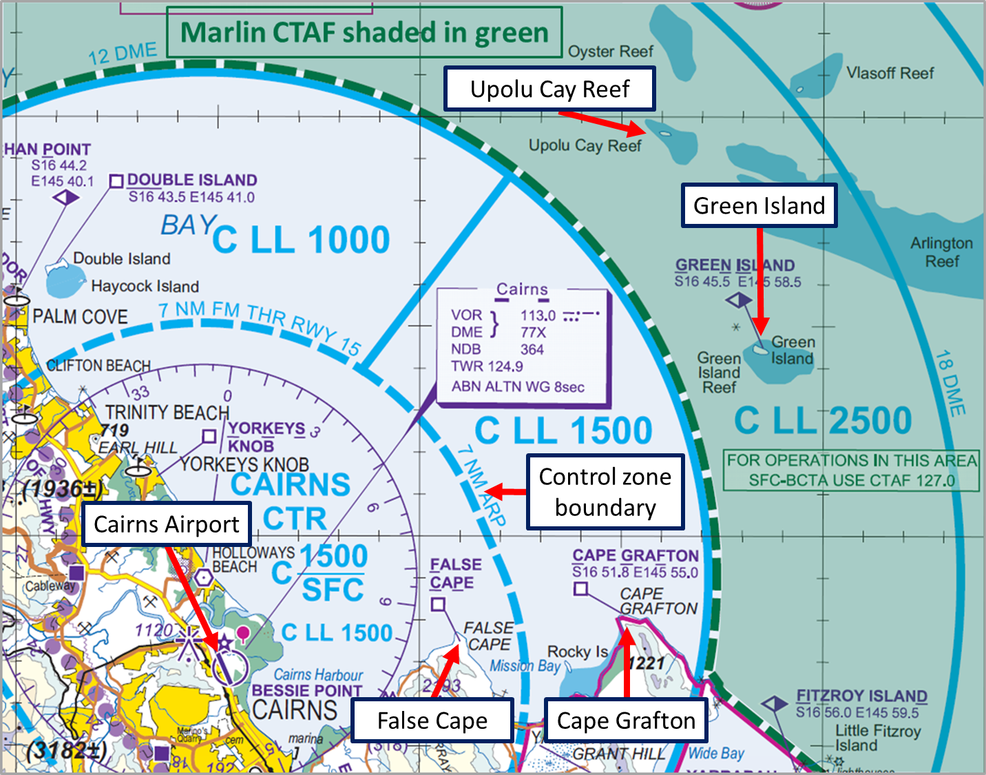
On 5 February 2017, at about 1639 Eastern Standard Time (EST), a Bell 407 helicopter, registered VH‑VHU (VHU), departed from Cairns Airport, Queensland, on a local scenic charter flight (visual flight rules), tracking towards Green Island (Figure 1). On board were the pilot and six passengers.
Figure 1: Extract of Cairns visual terminal chart showing the Marlin CTAF shaded in green, Green Island and Cape Grafton
Source: Airservices Australia – annotated by ATSB
At that time, a Piper PA-31-350 aircraft, registered VH-FDQ (FDQ), was also conducting a scenic charter flight in the area. At about 1640, the pilot of FDQ contacted the Cairns approach controller and requested clearance to enter the Cairns controlled airspace. The pilot advised that they were at 10 NM and at 1,000 ft and requested to return via either east of Cape Grafton or False Cape.[1] The controller acknowledged FDQ and confirmed that the pilot intended to remain outside controlled airspace and track to Cape Grafton. The pilot confirmed that they would complete an orbit at Green Island and then track to Cape Grafton at 1,000 ft (Figure 1). At about 1641, the approach controller suggested if available that the pilot of FDQ climb to 1,500 ft, as there were multiple helicopters in the area on climb to 1,000 ft (the same altitude as FDQ). Although outside controlled airspace, the controller provided traffic as a helicopter (not VHU) was already at 1,000 ft and about 2 NM W of FDQ. The pilot of FDQ responded that they would climb to 1,500 ft.
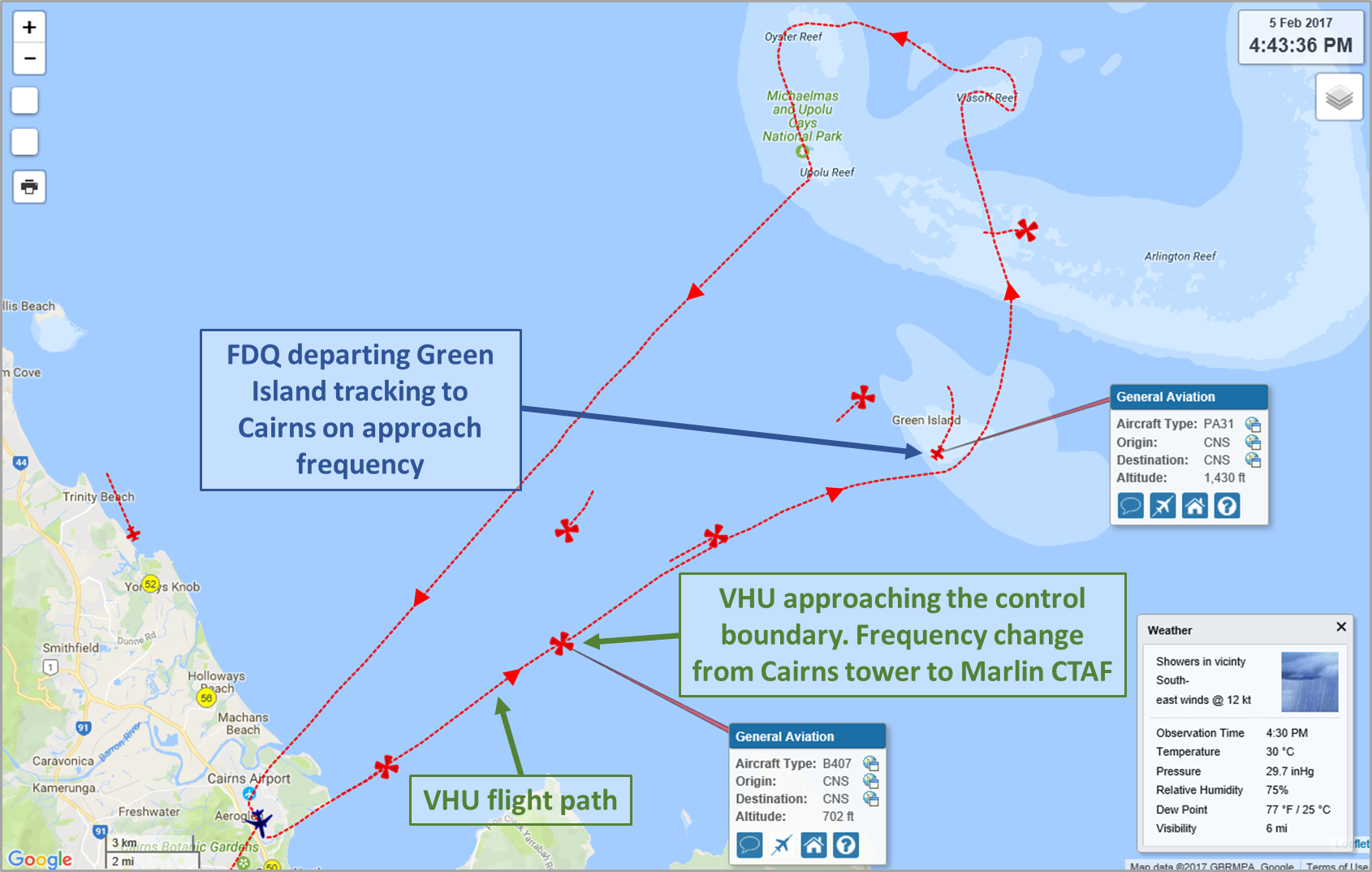
At about 1643, the tower controller notified VHU that they were approaching the control boundary and that control services were terminated. The pilot of VHU changed their radio from Cairns Tower to the Marlin common traffic advisory frequency (CTAF),[2] and broadcast that they were at the zone boundary and would track direct to Green Island climbing from 500 ft to 1,000 ft. The pilot did not receive a response and commenced the climb.
About 30 seconds later, the approach controller cleared the pilot of FDQ (then orbiting at Green Island) to track to Cairns via a left base circuit leg for runway 15 at 1,500 ft (Figure 2).
Figure 2: Location of VHU when changed to the Marlin CTAF and approximate location of FDQ when commenced tracking direct to Cairns
Source: Airservices Web Trak, modified by the ATSB
As VHU approached 900 ft on climb, the pilot indicated that their attention was inside the cockpit to ensure they did not climb above 1,000 ft and to set up the helicopter in the cruise. When the pilot subsequently scanned outside, they sighted an aircraft rapidly approaching[3] in the opposite direction (FDQ). The pilot of VHU conducted a rapid descent to increase the separation with FDQ and estimated that the vertical separation between the two aircraft was between 100 to 150 ft. [4] Radar data indicated that the minimum separation between the two aircraft was 400 ft vertically and 500 m horizontally.
Both aircraft subsequently landed without further incident.
Communications
At the time of the incident, the pilot of VHU had Marlin CTAF selected and was flying in an area where the Cairns Approach frequency should be monitored. At the same time, FDQ was on Cairns Approach frequency and flying in an area where the Marlin CTAF should be monitored.
The pilot of VHU commented that they were not aware of the pilot of FDQ’s intentions and did not expect to see an aircraft approaching rapidly in the opposite direction.
The pilot of VHU also commented that although the helicopter was fitted with two radios, they only selected and monitored one frequency at a time, to ensure that communications were not over-transmitted in a very busy airspace. For this flight, the frequency after leaving the Cairns control zone boundary and before the Marlin CTAF boundary was the Cairns Approach frequency.
The operator of FDQ indicated that they also have two radios and maintain an active listening watch on two frequencies.
The operator of VHU commented that immediately outside the Cairns control zone boundary pilots may not be monitoring a common frequency and therefore may not be aware of traffic advisory calls. As such, the operator of VHU believes there can be an elevated risk of a collision, particularly during times of high traffic.
Scenic flight routes
The operator of VHU commented that this incident occurred at one of the busiest times of the year for scenic flights by helicopters and fixed wing aircraft from Cairns to the Great Barrier Reef. The pilot of VHU reported that it would not be uncommon at this time of year to have eight to ten aircraft in the area conducting scenic flights at any one time. To ensure separation they usually fly a set route at a similar altitude and adjust their airspeed so that they follow each other.
At the time of this incident, the Civil Aviation Safety Authority (CASA) was liaising with Airservices and local charter operators to review procedures for possible flight corridors and altitudes to help maintain aircraft separation.
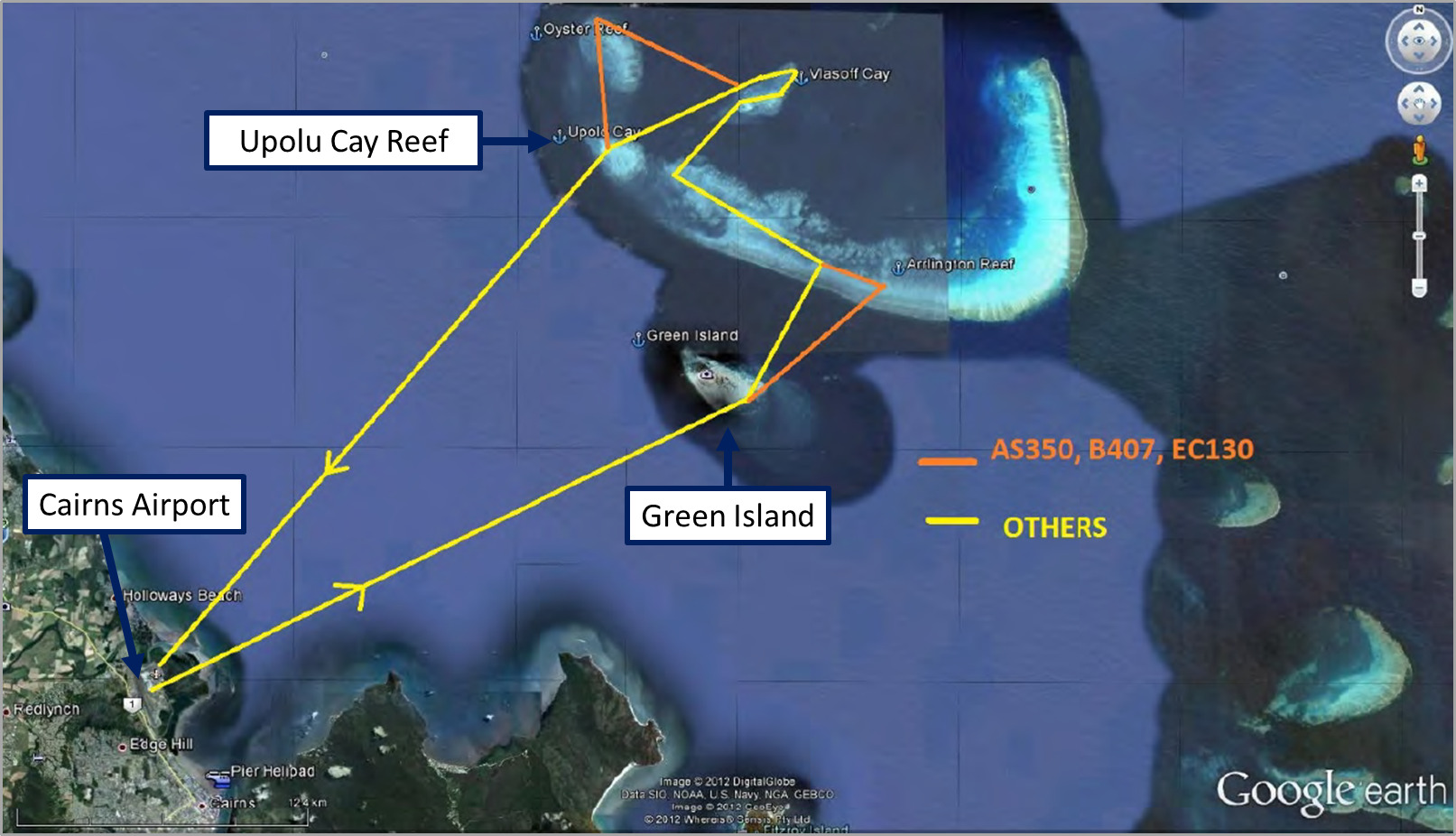
In the interim, on 10 January 2017, the operator of VHU sent an email to the chief pilots of other scenic flight operators with a suggested route for scenic flights (Figure 3). They reported that all helicopter operators agreed to fly in a counter-clockwise direction and that this had decreased the incidence of near collisions between helicopters.
Figure 3: Suggested route for scenic flights
Source: Helicopter operator– annotated by ATSB
Similar incidents
A search of the ATSB database identified one other occurrence in the 2 months before this incident that involved a near collision in the Marlin CTAF. A Cessna 172 was tracking in the Marlin CTAF from Upolu Cay Reef (Figure 1) to False Cape at 1,000 ft. The pilot of an Airbus Helicopters AS350 (AS350) had entered the Marlin CTAF tracking outbound, and broadcast on the Marlin CTAF their intention to track to Green Island and did not receive any response. The AS350 was on climb, passing about 750 ft, when the pilot reported that they had to take evasive action to avoid a collision with the Cessna 172.
In a submission to a draft of this report, CASA provided information about two other relevant near miss incidents, which had not been reported to the ATSB.
Findings
These findings should not be read as apportioning blame or liability to any particular organisation or individual.
- VHU and FDQ were on reciprocal tracks, near the control zone boundary, and the pilots were communicating on different radio frequencies at the time of the separation issue. Neither pilot was aware of the other aircraft prior to the incident.
- There are no published routes and procedures for scenic flights in the Cairns/Great Barrier Reef area. FDQ was operating contra to the inbound direction used by the helicopter operator, but in accordance with their air traffic control clearance, and still outside controlled airspace at the time of the incident.
Safety action
Whether or not the ATSB identifies safety issues in the course of an investigation, relevant organisations may proactively initiate safety action in order to reduce their safety risk. The ATSB has been advised of the following proactive safety action in response to this occurrence.
Civil Aviation Safety Authority
As a result of this occurrence, the Civil Aviation Safety Authority has advised the ATSB that they are taking the following safety actions:
CASA are engaged with Airservices and the local operators to find a workable safety outcome to the aircraft separation issues.
Safety message
This incident highlights the importance of effective risk analysis by operators. An effective risk analysis of the scenic routes would probably have highlighted the potential for opposite-direction traffic. This may have led to risk management strategies such as implementation of vertical separation planning.
A search for other traffic is eight times more effective when a radio is used in combination with a visual lookout than when no radio is used. In areas outside controlled airspace, it is the pilot’s responsibility to maintain separation with other aircraft. For this, it is important that pilots use both alerted and un-alerted see-and-avoid principles.
The ATSB report Limitations of the See-and-Avoid Principle outlines the major factors that limit the effectiveness of un-alerted see-and-avoid.
ATSB research has found that accidents and incidents are not always reported to the ATSB when they should be. It is possible that other occurrences related to this incident have not been reported to the ATSB.
While we use a notification to determine whether to investigate an occurrence, looked at as a whole, notifications also provides a bigger picture of aviation safety trends and patterns.

Aviation Short Investigations Bulletin - Issue 62
Purpose of safety investigationsThe objective of a safety investigation is to enhance transport safety. This is done through:
It is not a function of the ATSB to apportion blame or provide a means for determining liability. At the same time, an investigation report must include factual material of sufficient weight to support the analysis and findings. At all times the ATSB endeavours to balance the use of material that could imply adverse comment with the need to properly explain what happened, and why, in a fair and unbiased manner. The ATSB does not investigate for the purpose of taking administrative, regulatory or criminal action. TerminologyAn explanation of terminology used in ATSB investigation reports is available here. This includes terms such as occurrence, contributing factor, other factor that increased risk, and safety issue. Publishing informationReleased in accordance with section 25 of the Transport Safety Investigation Act 2003 Published by: Australian Transport Safety Bureau © Commonwealth of Australia 2017
Ownership of intellectual property rights in this publication Unless otherwise noted, copyright (and any other intellectual property rights, if any) in this report publication is owned by the Commonwealth of Australia. Creative Commons licence With the exception of the Coat of Arms, ATSB logo, and photos and graphics in which a third party holds copyright, this publication is licensed under a Creative Commons Attribution 3.0 Australia licence. Creative Commons Attribution 3.0 Australia Licence is a standard form licence agreement that allows you to copy, distribute, transmit and adapt this publication provided that you attribute the work. The ATSB’s preference is that you attribute this publication (and any material sourced from it) using the following wording: Source: Australian Transport Safety Bureau Copyright in material obtained from other agencies, private individuals or organisations, belongs to those agencies, individuals or organisations. Where you wish to use their material, you will need to contact them directly. |
__________
- When FDQ departed, there were two Cessna 208 aircraft (C208) that had just completed a scenic flight to Green Island and were holding at False Cape waiting to be sequenced for a landing at Cairns Airport. Due to the localised weather to the north of the airport prevented the C208 tracking via Upolu Cay to Cairns Airport.
- CTAF – Common Traffic Advisory Frequency. The frequencies allocated, are those on which pilots can arrange mutual separation at non-controlled aerodromes.
- The pilot of VHU estimated that their airspeed was about 100 kt and the closing speed between the two aircraft was about 200 to 240 kt.
- The incident occurred outside of controlled airspace.


