
What happened
At 0856 Central Standard Time (CST) on 25 May 2016, a Piper PA-32, registered VH-NKA (NKA), departed Darwin Airport, Northern Territory (NT) for a business flight to Oenpelli Airport, NT. On board were a pilot under supervision, a supervising pilot and two passengers. The pilot under supervision was the pilot flying (PF), with the supervising pilot acting as pilot monitoring (PM),[1] observing the flight and providing assistance.
At 0926, a Cessna 210, VH-SQT (SQT), departed Jabiru Airport, NT, for a scenic flight over Kakadu National Park and the East Alligator River, NT. On board were the pilot and five passengers. SQT initially proceeded in an easterly direction before progressing north along the river (Figure 1).
At about 0930, the PF in NKA assessed the expected weather conditions at Oenpelli and elected to make a straight-in[2] approach to runway 12. At this time, the PF made an inbound broadcast on the Jabiru-Oenpelli common traffic advisory frequency (CTAF), advising their position as 50 NM west of Oenpelli. The PF then descended the aircraft from the cruising altitude of 9,500 ft and made a further broadcast on the Jabiru-Oenpelli CTAF as the aircraft reached 15 NM from Oenpelli. The pilots of NKA received no response to these broadcasts.
Figure 1: Overview of incident location
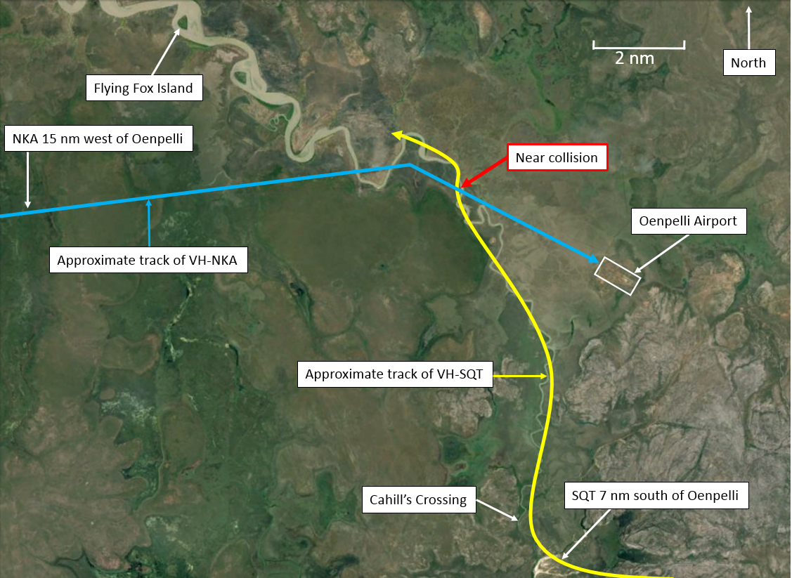
Source: Google Earth, annotated by ATSB
As SQT reached Cahill’s Crossing, 7 NM south of Oenpelli Airport, the pilot broadcast on Jabiru-Oenpelli CTAF, advising that they would be tracking north via the East Alligator River towards Flying Fox Island and operating not above 800 ft. The pilot did not receive a response to this broadcast.
At 0952, the PF in NKA established the aircraft on a 5 NM final approach leg to the runway at Oenpelli Airport at an altitude of 1,000 ft and configured the aircraft for landing. At the same time, the pilot of SQT continued to follow the East Alligator River north making continuous shallow turns left and right to maximise their passenger’s view. As SQT began a right turn, the pilot observed the shadow of another aircraft (subsequently determined to be NKA) tracking towards the shadow of their own aircraft. The pilot of SQT continued the right turn and assessed the position of the sun in relation to the shadow on the ground to establish the position of NKA. The pilot of SQT sighted NKA in close proximity and instinctively descended the aircraft to avoid a collision.
At this time, the PM in NKA, observing the high workload of the PF, elected to broadcast advising they were 4 NM from Oenpelli conducting a straight-in approach for runway 12.
At about the same time, the pilot of SQT broadcast on the CTAF to establish contact with NKA and advise of the near collision. The pilots of each aircraft communicated without difficulty following the incident.
The pilot of SQT estimated that the aircraft passed at the same altitude and a distance less than 100 m at the closest point. The pilots of NKA did not see SQT.
The pilots and passengers of both aircraft were not injured in the incident and the aircraft were not damaged.
Pilot Comment
The pilot of VH-NKA:
The supervising pilot of NKA provided the following comments:
- No radio calls were heard from the pilot in SQT prior to the incident, despite having experienced no communication difficulties prior to, or after the incident.
- Their view of SQT would have been obscured by the aircraft’s right wing as SQT approached their aircraft.
- The change to the Jabiru-Oenpelli CTAF was made slightly later than the usual distance of about 70 NM from Oenpelli Airport. This may have led to the pilots missing the departure call from the pilot in SQT.
- The pilot in command expressed concern at the planning of a low-level scenic flight through the extended centreline[3] of an aerodrome at a distance of 3 NM.
The pilot of VH-SQT:
The pilot of SQT provided the following comments:
- No radio calls were heard from the pilots in NKA prior to the incident despite hearing calls from other aircraft. The radio in use was tested immediately afterward and found serviceable.
- The incident occurred at the point they would normally make a radio call for transiting abeam Oenpelli Airport. The pilot spotted the shadow of NKA just as they were about to make the call.
- The avoiding action required was forceful, inducing slight negative ‘G’.[4] Had the pilot taken no avoiding action the two aircraft would have collided.
- The pilot did not expect an aircraft on approach to Oenpelli airport at a distance of 4 NM from the runway to be as low as 800 ft.
Safety action
Whether or not the ATSB identifies safety issues in the course of an investigation, relevant organisations may proactively initiate safety action in order to reduce their safety risk. The ATSB has been advised of the following proactive safety action in response to this occurrence.
Operator of VH-SQT
As a result of this occurrence, the operator of SQT has advised the ATSB that they have taken the following action:
Communications procedure
The communication procedures for scenic flights using this route have been changed. They will now include a broadcast when the aircraft are 3 NM from Oenpelli Airport, stating that the aircraft will be passing through the extended centreline of runway 12, operating at not above 800 ft.
Safety message
This occurrence highlights the importance of effective communications. Where this effectiveness is compromised, pilot lookout becomes increasingly important. The ATSB publication Limitations of the See-and-Avoid Principle provides information on developing effective lookout techniques.
The Civil Aviation Safety Authority (CASA) publication CAAP 166-2(1) Pilots’ responsibility for collision avoidance using ‘see-and-avoid’ provides information which can increase the probability of sighting traffic.
Fly neighbourly advice
ERSA - GEN - SP contains a fly neighbourly advice for pilots operating in the Kakdau National Park. Pilots intending to fly over Kakadu National Park should obtain, read and comply with the Kakadu Fly Neighbourly Agreement.
Aviation Short Investigations Bulletin - Issue 51
Purpose of safety investigationsThe objective of a safety investigation is to enhance transport safety. This is done through:
It is not a function of the ATSB to apportion blame or provide a means for determining liability. At the same time, an investigation report must include factual material of sufficient weight to support the analysis and findings. At all times the ATSB endeavours to balance the use of material that could imply adverse comment with the need to properly explain what happened, and why, in a fair and unbiased manner. The ATSB does not investigate for the purpose of taking administrative, regulatory or criminal action. TerminologyAn explanation of terminology used in ATSB investigation reports is available here. This includes terms such as occurrence, contributing factor, other factor that increased risk, and safety issue. Publishing informationReleased in accordance with section 25 of the Transport Safety Investigation Act 2003 Published by: Australian Transport Safety Bureau © Commonwealth of Australia 2016
Ownership of intellectual property rights in this publication Unless otherwise noted, copyright (and any other intellectual property rights, if any) in this report publication is owned by the Commonwealth of Australia. Creative Commons licence With the exception of the Coat of Arms, ATSB logo, and photos and graphics in which a third party holds copyright, this publication is licensed under a Creative Commons Attribution 3.0 Australia licence. Creative Commons Attribution 3.0 Australia Licence is a standard form licence agreement that allows you to copy, distribute, transmit and adapt this publication provided that you attribute the work. The ATSB’s preference is that you attribute this publication (and any material sourced from it) using the following wording: Source: Australian Transport Safety Bureau Copyright in material obtained from other agencies, private individuals or organisations, belongs to those agencies, individuals or organisations. Where you wish to use their material, you will need to contact them directly. |
__________
- Pilot Flying (PF) and Pilot Monitoring (PM) are procedurally assigned roles with specifically assigned duties at specific stages of a flight. The PF does most of the flying, except in defined circumstances; such as planning for descent, approach and landing. The PM carries out support duties and monitors the PF’s actions and aircraft flight path.
- An approach directly to the runway from the present position of the aircraft without joining the standard approach circuit or overflying the aerodrome.
- A theoretical line drawn out from and in line with the runway. The aircraft is required to be aligned along this extended centreline at a point no less than 3 nm from the runway threshold during a straight-in approach.
- The unit of measurement for measuring vertical acceleration within an aircraft. 1 G is equal to the force of gravity at the earth’s surface. In flight, g load values represent the combined effects of flight manoeuvring loads and turbulence. This can be a positive or negative value.