At about 0700 Eastern Standard Time[1] on Sunday 2 March 2014, the pilot of an amateur-built Van’s Aircraft RV-6, two-seat aeroplane, registered VH-ZMH and operated in the ‘Experimental’ category, took off from Gatton Airpark, a privately operated airstrip located about 4 km south-west of Gatton township, Queensland. The pilot conducted about 20 minutes of local area flying in the aircraft prior to returning to the airpark with no indications of any technical problems or issues with the aircraft or its systems. The aircraft was then seen to be operating at a low level over the airstrip.
A number of nearby witnesses described seeing the aircraft flying at about 20‑50 ft above the airstrip at a speed higher than that required for a normal landing or missed approach. Those witnesses also heard the aircraft and described the engine sound as ‘normal’. The aircraft was then observed to climb at a nose-up pitch attitude of about 10‑20° and commence a left roll.
The aircraft then lost height and collided with terrain at a high rate of descent. The aircraft was destroyed and the pilot was fatally injured.
Pilot information
The pilot held a Civil Aviation Safety Authority (CASA) student pilot licence and a Recreation Aviation Australia Incorporated pilot certificate. The pilot did not hold qualifications that entitled him to fly the aircraft as pilot in command.
The CASA Civil Aircraft Register indicated that the aircraft was registered to another person; however, it was likely that accident pilot had purchased and flown the aircraft for several years prior to the accident.
Recorded data
Images from security surveillance recordings from commercial premises adjacent to the airpark captured the aircraft shortly before its impact with terrain. These images showed the aircraft descending at a high rate of descent in a right‑wing low attitude immediately prior to colliding with terrain.
Wreckage examination
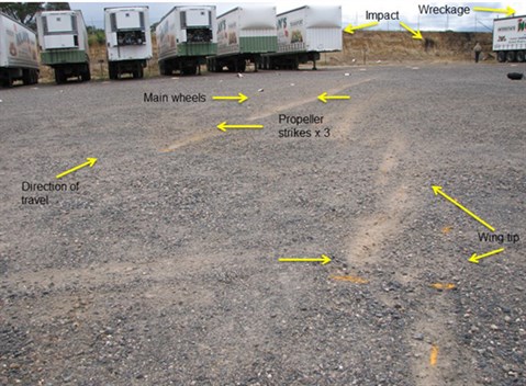
Examination of the aircraft wreckage identified no mechanical issues or faults with the aircraft that may have contributed to the accident. Ground impact marks showed that the aircraft’s right wing initially collided with terrain followed by the main landing gear wheels (Figure 1). The distance between the wheel marks was greater than the normal static dimension between the wheels, which indicated a significant downward load during the impact sequence.
The ground impact marks and the witness reports were consistent with the pilot performing a low‑level ‘roll’ aerobatic manoeuvre at a height from which recovery to normal flight was not completed before the aircraft collided with terrain.
Figure 1: Ground impact marks showing the impact sequence

Data gathered in support of the investigation is being analysed in terms of the scope of any continuing investigation. That analysis is anticipated for completion in June 2014.
_____________________________
The information contained in this web update is released in accordance with section 25 of the Transport Safety Investigation Act 2003 and is derived from the initial investigation of the occurrence. Readers are cautioned that new evidence will become available as the investigation progresses that will enhance the ATSB's understanding of the accident as outlined in this web update. As such, no analysis or findings are included in this update.
[1] Eastern Standard Time (EST) was Coordinated Universal Time (UTC) + 10 hours.


