History of the flight
At about 0855 Eastern Standard Time1 on 24 September 2005, a Raytheon Aircraft Company Beechcraft A-36 Bonanza, registered VH-BKM, took off from Murwillumbah, NSW, on a private flight to Coonabarabran, NSW, with one passenger, who was the pilot's wife, under the visual flight rules. The pilot had not submitted a flight plan or nominated a SARTIME2 and there was no requirement to do so. The pilot and passenger regularly flew return flights from Coonabarabran to Murwillumbah in this aircraft.
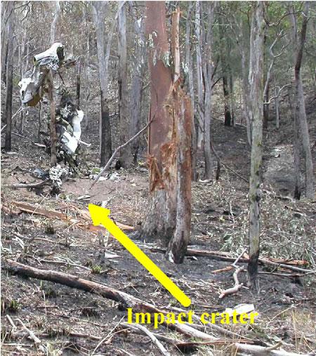
The aircraft was subsequently reported to be missing on 28 September 2005, and a search was commenced. The wreckage of the aircraft was located on 29 September 2005. The aircraft had impacted a heavily timbered hill on a private property 'Millera', located approximately 35 km east of Tenterfield. The aircraft had been destroyed by impact forces and a post-impact fire (Figure 1), and both occupants were fatally injured.
Figure 1: View of impact crater looking north-west
Operational Information
The pilot was 71 years old and held both commercial and private pilot licences for aeroplanes and had a valid Class 2 medical certificate. He held a pilot's licence for over 50 years and had previously owned and operated an aerial agricultural business. He had a total aeronautical experience of approximately 13,000 flying hours.
The aircraft had been owned and operated by the pilot for the previous 14 years. Maintenance records indicated that the aircraft had a valid maintenance release which was issued on 27 January 2005 and was valid for 12 months. The aircraft maintenance release was unable to be located in the wreckage, however the estimated total time in service of the aircraft at the time of the accident was 3,231 hours. The engine had been rebuilt and fitted to the aircraft in April 1992.
The aircraft was fitted with a two-axis autopilot which included separate roll and pitch engagement, altitude hold and automatic and manual electronic pitch-trim. The autopilot could be disconnected by pressing down on an electric pitch-trim switch on the control wheel, or by manually overriding the controls. The aircraft was fitted with a single control wheel.
Prior to the flight to Murwillumbah the aircraft was refuelled at Coonabarabran, from a fuel bowser owned by the pilot. Witnesses reported that the aircraft had been refuelled to its maximum capacity. Fuel records for the fuel supplied to the bowser indicated that the fuel sample in the supply truck was clear and free of sediment. The local aero club had been supplied with 400 L of fuel from the pilot's bowser and had not reported any problems with the fuel.
Performance calculations were used to estimate the fuel burn from Coonabarabran to Murwillumbah and from Murwillumbah to the accident site. These calculations indicated that approximately 140 L of fuel would have been on-board the aircraft at the time of the accident. Discolouration of tree foliage at the accident site and the extent of the post-impact fire confirmed that there was fuel in the aircraft when the accident occurred. Weight and balance calculations showed that the aircraft was within centre of gravity limits for the final flight.
Information provided by the Bureau of Meteorology indicated that a low-pressure trough was present to the west of Tenterfield on the morning of the accident. The weather forecast and actual observations indicated that the flight was conducted under visual meteorological conditions. Witnesses reported clear weather in the vicinity of the accident site.
The pilot had not submitted a flight plan for the flight or contacted air traffic control for an area QNH3 and was not required to do so. The recorded Air Traffic Services (ATS) radar data indicated that the aircraft was operating on a transponder code of 12004.
A review of recorded radar data indicated that the aircraft had been maintaining a stable heading and altitude for most of the flight, which was consistent with the autopilot having been engaged.
The aircraft had then descended from a cruising altitude of about 6,300 ft above mean sea level (AMSL) to a final recorded altitude of about 3,800 ft AMSL at a rate of approximately 5,000 ft/ min. The accident occurred at an approximate elevation of 1,000 ft AMSL.
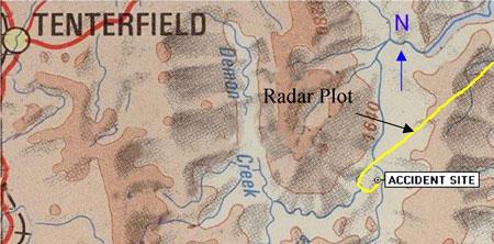
The recorded radar data of the aircraft's flight path was superimposed on a topographical chart that indicated that the aircraft had made a sudden left turn over the area of the accident site (Figure 2).
Figure 2: Radar plot of final segment of flight
There were no recorded radio transmissions from the aircraft prior to departure from Murwillumbah, or during the flight. The aircraft was fitted with a fixed emergency locator transmitter; however, it was destroyed at impact and was not capable of transmitting a distress signal.
Wreckage and impact information
The aircraft wreckage was fragmented and damage to the aircraft structure was consistent with a high-speed impact. There was no evidence of an in-flight breakup, birdstrike or in-flight fire prior to the accident and a technical examination of the engine and propeller indicated that they were producing power at the time of the accident.
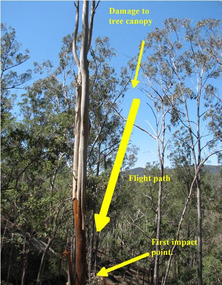
Ground contact marks indicated that the aircraft impacted the ground in a left wing-low, nose-down attitude. Damage to the tree canopy in the vicinity of the impact crater indicated an impact angle of 72 degrees to the horizontal (Figure 3). The aircraft's direction of flight at the time of the accident was estimated to be 290 degrees Magnetic.
Figure 3: Tree canopy damage
Post-mortem medical examination was unable to determine if the pilot had experienced any incapacitation prior to the accident. The pilot's medical records indicated that he was taking regular medication to control blood pressure and that he recently had undergone a minor surgical procedure to remove skin cancers but there was no evidence that either had a bearing on the accident.
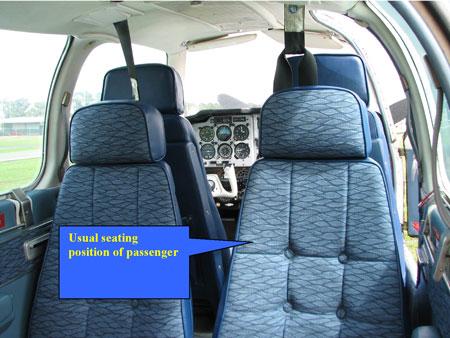
Witnesses reported that the passenger normally travelled in the second row of seats, which faced rearwards. The passenger would occupy the seat diagonally across from the pilot (Figure 4) and only communicate with the pilot occasionally during a flight. There was no evidence of the passenger having any aeronautical experience.
Figure 4: Seating configuration of aircraft
- The 24-hour clock is used in this report to describe the local time of day, Eastern Standard Time (EST), as particular events occurred. Eastern Standard Time was Coordinated Universal Time (UTC) + 10 hours.
- The time nominated by a pilot for the initiation of search and rescue action if a report has not been received by the nominated time.
- QNH is the altimeter subscale barometric pressure setting to provide altimeter indication of altitude relative to mean sea level. Area QNH is representative of the QNH of any location within a particular area.
- A transponder is a receiver/transmitter which will generate a reply signal upon proper interrogation of an air traffic control radar signal.