
On 6 April 2005, at 1253 Eastern Standard Time, a de Havilland Canada DHC-8-102 (Dash 8) aircraft departed Mackay for Townsville, Qld. The aircraft was being operated under the instrument flight rules (IFR) and was climbing to flight level (FL) 160. At 1254, a Boeing Company 737-800 (737) aircraft departed Proserpine for Brisbane, Qld. The aircraft, with two pilots and a company approved observer, was being operated under the IFR. The crew's intention was to climb the aircraft to 8,000 ft above mean sea level (AMSL) pending a clearance from air traffic control (ATC) to enter controlled airspace (CTA) on climb to the planned FL410.
The airspace in the Proserpine area was classified as class G (non-controlled) airspace from ground level to 4,500 ft and class C (controlled) airspace from 4,500 ft to FL180.
Within class C airspace, air traffic controllers are required to separate IFR aircraft from other IFR aircraft.
Figure 1: Extract from Mackay Terminal Area Chart
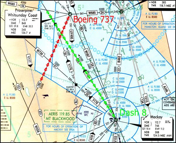
At 1256, the sector controller issued the crew of the 737 with a clearance to enter CTA on climb to 5,000 ft to establish the minimum vertical separation standard of 1,000 ft with the Dash 8, prior to conducting a step climb1. The 737 crew reported they were approaching 6,000 ft and commenced a descent to 5,000 ft.
Recorded data later showed that the 737 reached a maximum altitude of 6,400 ft with a minimum vertical spacing between the two aircraft of 430 ft and it was calculated that the aircraft were approximately 45 NM apart laterally. At 1257, the vertical separation standard of 1,000 ft was established and, at 1300 when the two aircraft were radar identified, they were about 25 NM apart laterally.
At the time of the incident, the radar that normally provided low-level coverage within the area had been temporarily removed from service, restricting coverage to above 8,000 ft. A notice to airmen (NOTAM) had been issued, which detailed the planned outage, the restricted radar coverage, and possible delays in CTA.
The crew of the 737 later reported that they had obtained and read briefing material, including NOTAMs, but did not recall any information relating to the radar outage. They first became aware of the outage at about 9,000 ft during the previous flight on the inbound descent to Proserpine, when they were instructed by the controller that the radar was off and radar services were terminated. At that point, they mistakenly confused the termination of radar services with a change in the base of CTA to 9,000 ft. Prior to departure from Proserpine, the crew briefed and set 8,000 ft as an initial level for climb, believing this level to be outside CTA.
The published minimum sector altitude (MSA)2 around Proserpine was 4,500 ft within 10 NM and 5,100 ft within 25 NM. The lowest safe altitude (LSALT) for the departure track of the 737 was 5,500 ft. As a result, the cleared level of 5,000 ft was below the LSALT for the aircraft.
The forecast cloud at Proserpine was scattered at 2,000 ft and broken at 4,000 ft and the 737 crew later reported entering instrument meteorological conditions (IMC) when passing about 2,500 ft on the departure climb.
The Manual of Air Traffic Services (MATS) section 6.1.2.1 specified that clearances issued shall enable the pilot to comply with Civil Aviation Regulations (CAR) 157, relating to minimum heights for aircraft operations. CAR 178 specified that a pilot must not fly an aircraft at a height lower than the published lowest safe altitude, 'and on departure this means the time during which an aircraft is climbing after take-off at a rate that is reasonable under the circumstances'. MATS 6.1.2.5 specified level assignment shall take into account terrain clearance and MATS 6.1.7.1 specified that a pilot may [only] be assigned a level below the LSALT provided that the pilot has reported 'visual' and 'visual' is appended to the clearance.
The air traffic controller later stated that he understood that the responsibility for terrain clearance on departure was a pilot responsibility and there was a published LSALT on the departure track for pilot reference. As he did not expect the aircraft to have to maintain 5,000 ft in the step climb, he did not issue a 'visual' instruction with the level assignment.
MATS 4.1.1.4 provided guidance to controllers relating to tactical separation assurance, which:
'places greater emphasis on traffic planning and conflict avoidance rather than conflict resolution. This is achieved through the proactive application of separation standards to avoid rather than resolve conflicts; planning traffic to guarantee rather than achieve separation; executing the plan so as to guarantee separation; and monitoring the situation to ensure that plan and execution are effective.'
- Step climb is a procedure used to simultaneously climb aircraft to vertically separated levels.
- Minimum sector altitude (MSA) and lowest safe altitude (LSALT) are calculated to provide 1000 ft obstacle clearance for IFR flights, and are published on aeronautical charts and in the Aeronautical Information Publication (AIP) for pilot and controller reference.