What happened
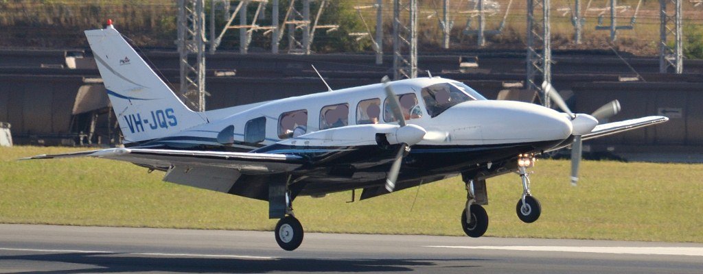
On the morning of 29 March 2017, a Piper PA-31-350 aircraft (Figure 1), registered VH-JQS, was on a private visual flight rules flight from Moorabbin, Victoria (Vic.) to Barwon Heads/Geelong aeroplane landing area (Barwon Heads ALA),[1] Vic. The pilot was the only person on board.
Figure 1: The occurrence aircraft, VH-JQS

Source: www.cqplanespotting.blogspot.com.au
At about 1015 Australian Eastern Daylight Time (AEDT), the aircraft was on approach to runway 36 at Barwon Heads ALA. The aircraft was configured with the landing gear extended and full flaps selected.
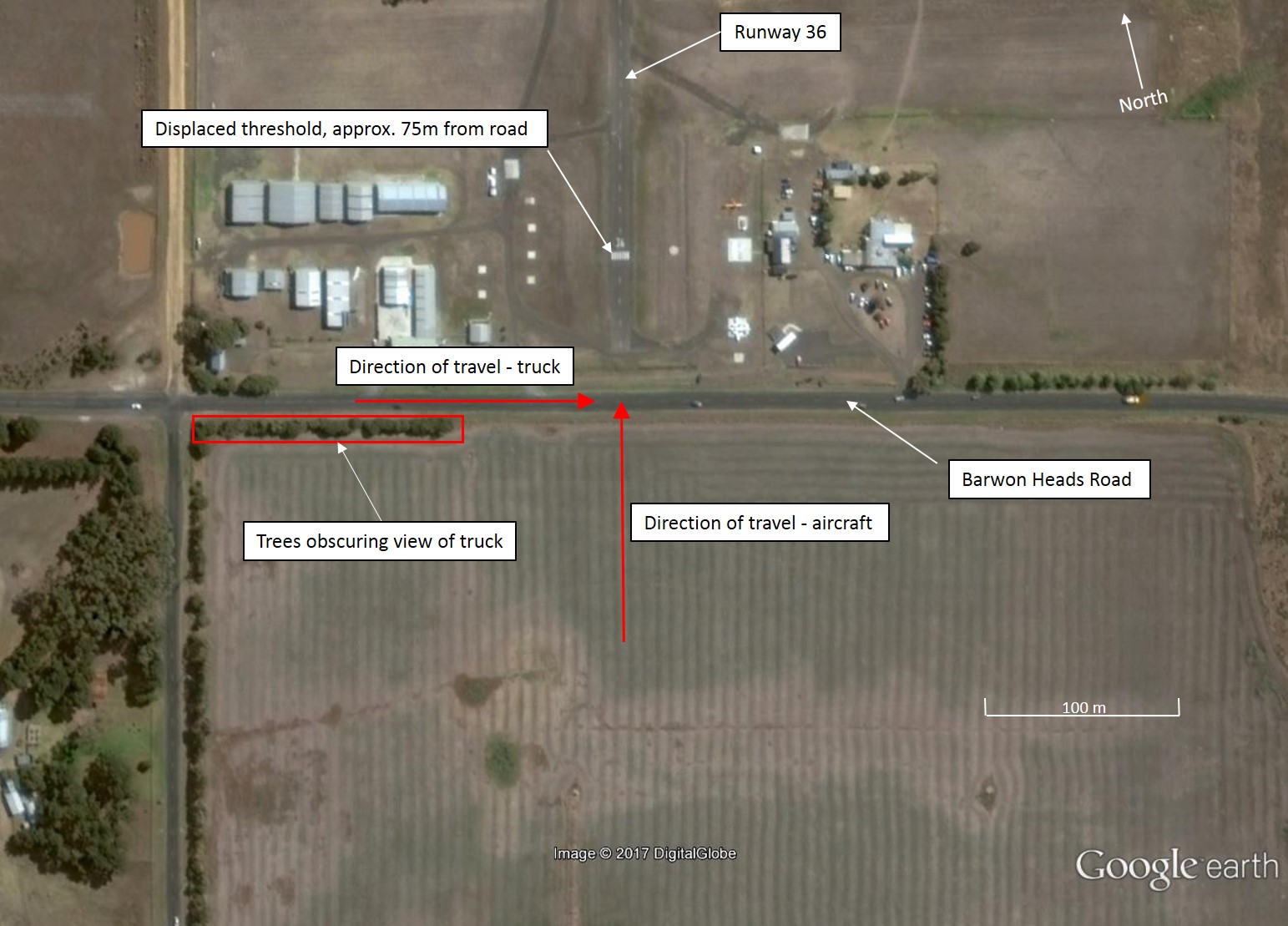
At a distance of about 0.5 NM (0.9 km) from runway 36, the pilot detected the aircraft becoming slightly low on the desired approach profile. The pilot retracted the flaps by 10° in an attempt to reduce the rate of descent. As the aircraft approached runway 36, the pilot noticed the aircraft was still lower than intended and decided to increase power. The pilot looked down momentarily at the throttle quadrant as they put their hand on the throttle control. As they looked back up, they observed a truck approaching from the left along Barwon Heads Road (Figure 2).
The pilot applied full power to conduct a go-around.[2] As full power was applied, the aircraft passed over Barwon Heads Road and the left main landing gear impacted the truck. The pilot observed the truck continue on Barwon Heads Road without stopping and the pilot continued with the go-around. The pilot elected to leave the landing gear extended in case it had sustained damage.
Figure 2: Barwon Heads/Geelong aeroplane landing area (ALA).

Source: Google Earth, annotated by ATSB
After completing the go-around, the pilot conducted two low passes over the airfield to determine the extent of any damage. During the first pass, the pilot contacted another pilot on the ground who had recently landed. The pilot on the ground was able to confirm that all three landing gear appeared to be intact. On the second pass, the pilot yawed[3] the aircraft left and right to ensure the landing gear was secure.
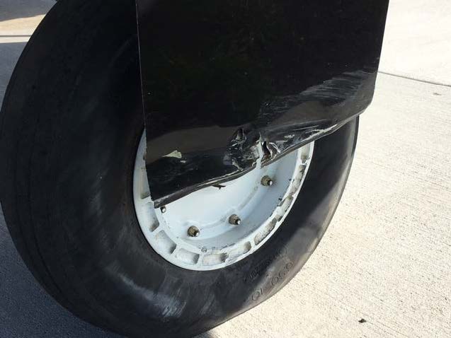
The pilot subsequently landed the aircraft without incident. The pilot was uninjured, and the aircraft sustained minor damage (Figure 3).
Figure 3: Damage to left main landing gear of VH-JQS.

Source: Pilot
Pilot comments
The pilot of VH-JQS provided the following comments:
- They had flown into Barwon Heads regularly over the previous five to six years and were familiar with the airport, including the displaced threshold and the vicinity of the Barwon Heads Road.
- In addition to flying duties, the pilot was also working as the company maintenance controller, and had recently taken on extra administrative duties. They stated that they were distracted during the incident flight by these additional pressures.
- The desired approach profile was about a 3° (5 %) descent profile. The pilot was aiming to land about a quarter of the way into the runway in order to ensure clearance over Barwon Heads Road.
- There were no issues with visibility or cloud cover but there was a gusting wind from the north-west. The aircraft became low on approach due to turbulence and windshear.
- When they realised they were becoming low on the approach the pilot reduced flaps by 10° rather than apply power. This was done to avoid reheating the turbo chargers as they had already cooled.
- The truck was not detected earlier as it had been obscured by a row of trees to the south-west of the airport.
Truck driver comments
The driver of the truck provided the following comments:
- The truck driver felt what they thought was downwash from the aircraft but was unaware that contact had been made. At no time did they see the aircraft. It was only when the truck driver reached their destination that they saw the impact marks and damage to the top of the truck and realised contact had been made.
- The truck was 3.950 m in height.
Airport operator comments
The airport operator provided the following comments:
- In late 2014, Barwon Heads ALA underwent a number of upgrades. These upgrades included sealing of runway 36 and improvements to the runway lighting. As part of these upgrades, the airport operator also proposed lengthening runway 36 to the north so that the displaced threshold could be moved further north. This would have allowed more clearance for aircraft flying over Barwon Heads Road. The operator stated that this aspect of the application was rejected by the local council (see Local council comment below) so the application went ahead without this component.
- The Aeronautical Information Package (AIP) En Route Supplement Australia (ERSA) states that prior permission is required to land at Barwon Heads ALA. This was done to convey information regarding the airport and runways. This information included the displaced threshold and road to the South of runway 36. The airport information was also available online (YBRS Runway Information - Barwon Heads Airport).
Local council comment
The local council commented that in general, the use of land as a transport hub (airport) is prohibited in a farming zone. However, the existing ALA site had operated as an airport for a period of almost 40 years and had existing use rights across the entire lot. These existing use rights, however, did not extend to the land north of the runway. Because of this, the council could not consider the part of the airport operator’s application relating to the extension of the runway to the north.
Adjusting decent rate during approach
The CASA flight instructor manual states that for an engine assisted approach:
The use of power on the approach enables the rate of descent to be adjusted safely over a very wide range.
Additionally, the Civil Aviation Authority New Zealand circuit training guidance states that:
The approach path is monitored by reference to the correct runway perspective. Throughout the descent the aiming point, commonly the runway numbers or threshold, is monitored and the power adjusted as required to maintain a steady rate of descent to touchdown.
Power controls the rate of descent
With the aeroplane trimmed to maintain the required attitude (airspeed), if the aiming point moves up the windscreen, the aeroplane is undershooting – increase power. If the aim point moves down the windscreen, the aeroplane is overshooting – decrease power.
Runway 36 displaced threshold
The Civil Aviation Safety Authority (CASA) provides guidance regarding the recommended minimum physical characteristics of landing areas in the Civil Aviation Advisory Publication (CAAP) 92-1(1): Guidelines for aeroplane landing areas.
Section 5.5 of that document stated:
Both ends of a runway, not intended solely for agricultural operations, should have approach and take-off areas clear of objects above a 5 % slope for day and a 3.3 % slope for night operations.
Barwon Heads Road is in close proximity to runway 36 (Figure 2). The start of runway 36 was about 25 m from the road, and the displaced threshold was 78 m from the road. Additionally, the elevation of the runway at the threshold was 0.31 m higher than that of the road. Using the 5 per cent approach recommended by CAAP 92-1, a distance of 78 m results in a height of 3.9 m (see Figure 5) over the runway elevation, providing a total road-crossing height of 4.21m. The VicRoads vehicle height limit in Victoria for road vehicles was 4.6 m.
Figure 5: Diagram showing a 5 per cent (3 degree) approach profile for Barwon Heads runway 36 and the proximity of Barwon Heads Road. A 5 per cent descent gradient aiming at the threshold results in aircraft passing over Barwon Heads Road at 4.21m which is lower than the VicRoads vehicle height limit of 4.6m.
Source: ATSB
While this incident occurred during daytime, runway 36 at Barwon Heads ALA is available for night use and is equipped with pilot activated lighting. Using the 3.3 per cent slope recommended by CAAP 92-1 for night operations, a distance of 78 m results in a height over Barwon Heads Road of 2.88 m (including the 0.31 m elevation difference). A review of the ATSB’s aviation occurrence database showed no similar occurrences on approach to runway 36 at Barwon Heads ALA have been reported to the ATSB.
Safety analysis
At about half a nautical mile from the runway, the aircraft became low on the approach. When the pilot recognised that the aircraft was too low, they elected to reduce the flap setting by 10° rather than add power. As the aircraft got closer to the runway, the aircraft was still lower than the desired approach profile, at which point the pilot elected to add power to gain height. Despite this action, the aircraft remained below the desired approach profile until it made contact with the truck.
The threshold of runway 36 was 78 m from Barwon Heads Road (Figure 2). Using the 5 per cent approach recommended by CAAP 92-1, a distance of 78 m results height of 3.9 m above the runway elevation. Combining this with the 0.31 m elevation difference, results in a clearance of 4.21 m which is less than the 4.6 m road vehicle height permitted in Victoria. Therefore, a normal approach aiming for the threshold of runway 36 at Barwon Heads can intersect with road vehicles on Barwon Heads Road.
Findings
These findings should not be read as apportioning blame or liability to any particular organisation or individual.
- The aircraft descended below the desired approach profile and the corrective action was not effective in sufficiently reducing the rate of descent.
- The displaced threshold on runway 36 at Barwon Heads does not provide the level of clearance recommended by the Civil Aviation Safety Authority Civil Aviation Advisory Publication 92-1.
Safety message
The guidance provided by CAAP 92-1 regarding the recommended minimum physical characteristics of ALAs is not compulsory. Therefore, pilots should not expect the same conditions and protections at an ALA as they would expect at a registered airport. When preparing to operate to ALAs, pilots should gain as much local knowledge about the landing site as possible. This can be achieved by consulting the ERSA and calling ahead for prior permission and/or airfield information. Aerodrome operators can help facilitate this by distributing relevant information in the ERSA, on their website or by requesting prior permission, as done by Barwon Heads ALA.
This occurrence involved an experienced pilot with over 4,000 hours total flying time and over 1,000 hours as an instructor. Additionally, the pilot had flown into Barwon Heads ALA numerous times previously and was familiar with the displaced threshold and the proximity of the road. Despite this experience, and even with local knowledge, this occurrence resulted in the aircraft impacting a truck while on approach to Barwon Heads ALA. The ATSB’s aviation occurrence database shows that experience does not grant immunity from fatal accidents and in 2013 the ATSB published its sixth report of the avoidable accident series Experience won’t always save you.
Aviation Short Investigations Bulletin - Issue 62
Purpose of safety investigationsThe objective of a safety investigation is to enhance transport safety. This is done through:
It is not a function of the ATSB to apportion blame or provide a means for determining liability. At the same time, an investigation report must include factual material of sufficient weight to support the analysis and findings. At all times the ATSB endeavours to balance the use of material that could imply adverse comment with the need to properly explain what happened, and why, in a fair and unbiased manner. The ATSB does not investigate for the purpose of taking administrative, regulatory or criminal action. TerminologyAn explanation of terminology used in ATSB investigation reports is available here. This includes terms such as occurrence, contributing factor, other factor that increased risk, and safety issue. Publishing informationReleased in accordance with section 25 of the Transport Safety Investigation Act 2003 Published by: Australian Transport Safety Bureau © Commonwealth of Australia 2017
Ownership of intellectual property rights in this publication Unless otherwise noted, copyright (and any other intellectual property rights, if any) in this report publication is owned by the Commonwealth of Australia. Creative Commons licence With the exception of the Coat of Arms, ATSB logo, and photos and graphics in which a third party holds copyright, this publication is licensed under a Creative Commons Attribution 3.0 Australia licence. Creative Commons Attribution 3.0 Australia Licence is a standard form licence agreement that allows you to copy, distribute, transmit and adapt this publication provided that you attribute the work. The ATSB’s preference is that you attribute this publication (and any material sourced from it) using the following wording: Source: Australian Transport Safety Bureau Copyright in material obtained from other agencies, private individuals or organisations, belongs to those agencies, individuals or organisations. Where you wish to use their material, you will need to contact them directly. |
__________
- Aeroplane landing area: An area of ground suitable for the conduct of take-off and landing of aeroplanes.
- Go-around: the procedure for discontinuing an approach to land, is a standard manoeuvre performed when a pilot is not completely satisfied that the requirements for a safe landing have been met. This involves the pilot discontinuing the approach to land and may involve gaining altitude before conducting another approach to land.
- Yawing: the motion of an aircraft about its vertical or normal axis.


