Preliminary report released 18 December 2024
This preliminary report details factual information established in the investigation’s early evidence collection phase, and has been prepared to provide timely information to the industry and public. Preliminary reports contain no analysis or findings, which will be detailed in the investigation’s final report. The information contained in this preliminary report is released in accordance with section 25 of the Transport Safety Investigation Act 2003.
The occurrence
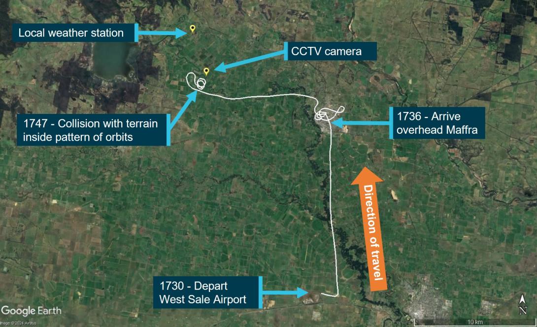
At 1730 local time on 16 November 2024, an amateur-built Morgan Cougar Mk 1 aircraft, registered VH-LDV (LDV), with a pilot and 2 passengers onboard, departed from West Sale Airport, Victoria for a flight over the local area. Flightradar24 data indicated the aircraft conducted a left turn on departure and tracked 8 NM (15 km) north of West Sale Airport to the town of Maffra. The aircraft arrived overhead Maffra shortly after 1736 where LDV made a series of turns overhead the town for about 4 minutes. At 1740, the aircraft departed from overhead Maffra and tracked about 6 NM (11 km) west-north-west towards Tinamba West (Figure 1).
The aircraft conducted a right-hand turn overhead a property at Tinamba West, which belonged to relatives of the aircraft occupants, before commencing a series of left-hand turns (orbits) around a point about 1 km to the south-east of the property over open paddocks. The last data point was at 1747, after LDV had commenced a third left-hand orbit, which recorded the aircraft at an altitude of 450 ft at a groundspeed of 60 kt on a track of 073° True (T).
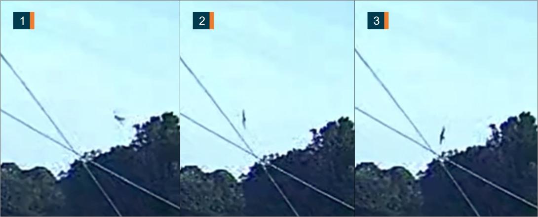
A closed-circuit television (CCTV) camera, located about 700 m north-north-east of the accident site, captured LDV in a left turn towards the camera. Subsequently, the nose of the aircraft pitched down and the aircraft descended in the left turn behind trees (Figure 2). About 14 seconds later a plume of dark smoke rose up above the trees. The 3 occupants were fatally injured in the accident and the aircraft was destroyed.
Context
Local weather data
A local weather station, about 4 km north of the accident site, recorded the following temperature and wind velocity information at 1745 and 1750 on the day of the accident:
Table 1: Local weather data
Time |
Temperature (°C) |
Wind speed (kt) |
Wind gust (kt) |
Wind direction (°T) |
1745 |
27.5 |
6.2 |
8.0 |
124 |
1750 |
27.3 |
6.4 |
12.8 |
122 |
Accident site
The aircraft impacted flat and open terrain at an elevation of about 130 ft and produced a ground scar on a track of 315° T (Figure 3). The length of the wreckage trail was about 30 m from the first ground scar to the propeller spinner, with the fuselage resting on a heading of 303° T. There was a diamond-shaped fuel spray and debris pattern along the wreckage trail.
Fuel was ignited after the ground impact, however, most of the fire damage to the aircraft was confined to the fuselage within the area bounded by the firewall, aft bulkhead (behind rear seats) and the inboard sections of the wings. The wings and tailplane (except the rudder) remained attached to the fuselage. The engine was attached to the firewall and the 3-bladed propeller was attached to the engine. One propeller blade was attached to the hub and the other 2 propeller blades had separated at their roots but were found within the debris field.
Figure 1: Accident flightpath with key timings and locations
Source: Flightradar24 and Google Earth, annotated by the ATSB
Figure 2: CCTV footage of final turn
Images subject to visual distortion (fisheye lens effect).
Source: Victoria Police, annotated by the ATSB
Figure 3: Accident site
Source: ATSB
Further investigation
To date, the ATSB has:
- examined the accident site
- retrieved hardware and avionics from the wreckage
- collected witness statements, CCTV and drone footage, local weather data, pilot licencing and medical information and aircraft records.
The investigation is continuing and will include:
- examination and analysis of the avionics unit and aircraft hardware
- a review of aircraft records, including design and certification standards
- a review of witness reports
- interviews with key personnel.
A final report will be released at the conclusion of the investigation. Should a critical safety issue be identified during the course of the investigation, the ATSB will immediately notify relevant parties so appropriate and timely safety action can be taken.
Acknowledgements
The ATSB acknowledges the support provided by Victoria Police during the onsite investigation phase.
Purpose of safety investigationsThe objective of a safety investigation is to enhance transport safety. This is done through:
It is not a function of the ATSB to apportion blame or provide a means for determining liability. At the same time, an investigation report must include factual material of sufficient weight to support the analysis and findings. At all times the ATSB endeavours to balance the use of material that could imply adverse comment with the need to properly explain what happened, and why, in a fair and unbiased manner. The ATSB does not investigate for the purpose of taking administrative, regulatory or criminal action. TerminologyAn explanation of terminology used in ATSB investigation reports is available here. This includes terms such as occurrence, contributing factor, other factor that increased risk, and safety issue. Publishing informationReleased in accordance with section 25 of the Transport Safety Investigation Act 2003 Published by: Australian Transport Safety Bureau © Commonwealth of Australia 2024
Ownership of intellectual property rights in this publication Unless otherwise noted, copyright (and any other intellectual property rights, if any) in this report publication is owned by the Commonwealth of Australia. Creative Commons licence With the exception of the Commonwealth Coat of Arms, ATSB logo, and photos and graphics in which a third party holds copyright, this report is licensed under a Creative Commons Attribution 4.0 International licence. The CC BY 4.0 licence enables you to distribute, remix, adapt, and build upon our material in any medium or format, so long as attribution is given to the Australian Transport Safety Bureau. Copyright in material obtained from other agencies, private individuals or organisations, belongs to those agencies, individuals or organisations. Where you wish to use their material, you will need to contact them directly. |