Executive summary
What happened
On the evening of 5 October 2023, the pilot launch Corsair was retrieving the pilot from the outbound container ship MV Rio Grande after it had departed Port Phillip. The transfer of the pilot to the launch took place offshore, about 4.2 km south‑west of Point Lonsdale. Port Phillip Sea Pilots (PPSP) was the pilotage service provider and operator of the pilot launch.
The pilot launch commenced its return to the entrance of Port Phillip at about 2307 intending to return to the pilot station at Queenscliff, inside the bay. At about 2310 and when about 2.3 km south‑west of Point Lonsdale, the coxswain commenced a slow course alteration to port of about 18º. Corsair was about 760 m from Point Lonsdale Reef when it steadied on a course towards the reef. Corsair was west of the location intended by the coxswain and subsequently ran aground on Point Lonsdale Reef at about 2313 travelling at 24 knots.
What the ATSB found
It was found that the coxswain of Corsair misinterpreted the leading lights marking the entry to Port Phillip and navigated to the west of their intended course through the entrance. The return to Port Phillip following offshore pilot transfer was a routine activity which had been performed by the coxswain on many occasions. On this night, their perception of navigational lights on Shortland Bluff was probably influenced by their expectations of what they would normally observe.
The likelihood of human error can be reduced by using protective systems of technology, other crew resources, and procedure. In this instance, the coxswain’s navigation of Corsair back to the entrance was predominantly visual with limited reference to onboard equipment to confirm the vessel’s approach. The other launch crew member, a deckhand, was also not actively involved with the vessel’s navigation.
A vessel’s safety management system provides the structures and guidance to support a consistent approach to vessel operations. It was found that the pilot launch safety management system and procedures could be improved with guidance to the launch crew on operational practices for navigation through the entrance to Port Phillip and the effective use of the launch’s equipment and deckhand.
It was also found that training material for launch coxswains contained limited detail on course content and assessment criteria, and training records were incomplete. There was also no refresher crew training in navigational practices.
Although not considered to have influenced this occurrence, additional findings are made on the potential for review by Safe Transport Victoria of the local knowledge certification requirements for masters of domestic commercial vessels operating in Port Phillip Heads.
What has been done as a result
Port Phillip Sea Pilots has developed additional guidance material for pilot launch operations and the use of equipment and crew resources. Training of coxswains and deckhands in crew resource management has also commenced. This work is ongoing and includes the review of the vessel risk register considering single person error and further updates to safety management and training systems. Significant upgrades have been made to launch navigational equipment.
Safety message
The incidence of human error can be reduced through effective use of available resources including a vessel’s equipment and crew. Vessel safety management systems and training should guide crew in the use of such resources.
The occurrence
Prior to the grounding
On 5 October 2023, the Port Phillip Sea Pilots (PPSP) night shift crew of PV Corsair reported on duty at the launch station at Queenscliff harbour at about 1900 local time. The crew comprised the launch coxswain[1] and deckhand. The crew’s first scheduled pilot transfer was later that evening. It involved retrieval of the pilot from the outbound container ship MV Rio Grande after it had departed Port Phillip. The pilot launch was prepared for service and the crew then waited in the crew quarters at the launch station.
At about 1952 that evening, Rio Grande departed Melbourne with a pilot on board and travelled south towards the entrance to Port Phillip (Figure 1).[2]
Figure 1: Port Phillip
Source: Google Earth © 2024 annotated by the Office of the Chief Investigator
At about 2230, the PPSP pilot despatch officer informed the launch crew that Rio Grande was expected to be at the Heads at about 2300. The launch crew boarded Corsair and departed the wharf at about 2244. At about 2253, Corsair and Rio Grande converged inside the Heads and from there the ship and launch travelled out through the entrance.
The pilot and coxswain established VHF radio contact at about 2255 and agreed that the ship and launch would rendezvous about 2 nautical miles (NM)[3] offshore and to the south‑west of the entrance in relatively calmer waters. More central to the entrance, seas were rougher due to the strong ebb tide, an opposing sea and a strong breeze from the south-south-west.
Once clear of the Heads, Rio Grande turned to starboard to create a lee on its starboard side for the launch to come alongside to retrieve the pilot. The pilot disembarked the ship onto the launch at about 2306. Soon after, from a position about 2.25 NM (4.2 km) south‑west of Point Lonsdale,[4] Corsair commenced heading back to the entrance of Port Phillip at speeds of between 21 and 24 knots.[5]
At the time, the sky was overcast and dark and the moon had not yet risen.[6] The meteorological visibility considering atmospheric conditions was reported as 7.4 NM.[7]
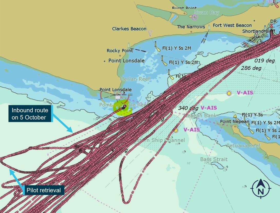
The grounding
For its return to Queenscliff, Corsair initially settled on a heading 067º and then 070º (Figure 2). On this course, Corsair would pass clear of Point Lonsdale Reef.
Figure 2: The heading vector of PV Corsair at 2310 prior to course alteration to port
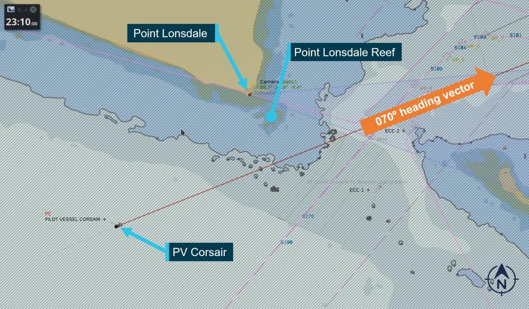
The figure shows the course vector of PV Corsair at 2310 when on a 070º heading and about 2.3 km from Point Lonsdale.
Source: Ports Victoria, annotated by the Office of the Chief Investigator
At about 2310, when about 1.25 NM (2.3 km) south‑west of Point Lonsdale and about 2.2 km from the Point Lonsdale Reef, the coxswain commenced a slow alteration of course to port. This course alteration was intended to bring them to the west of the Outer Western (shipping) Channel and onto the four fingers west[8] small craft approach to the entrance. However, Corsair was considerably further west than the coxswain realised.
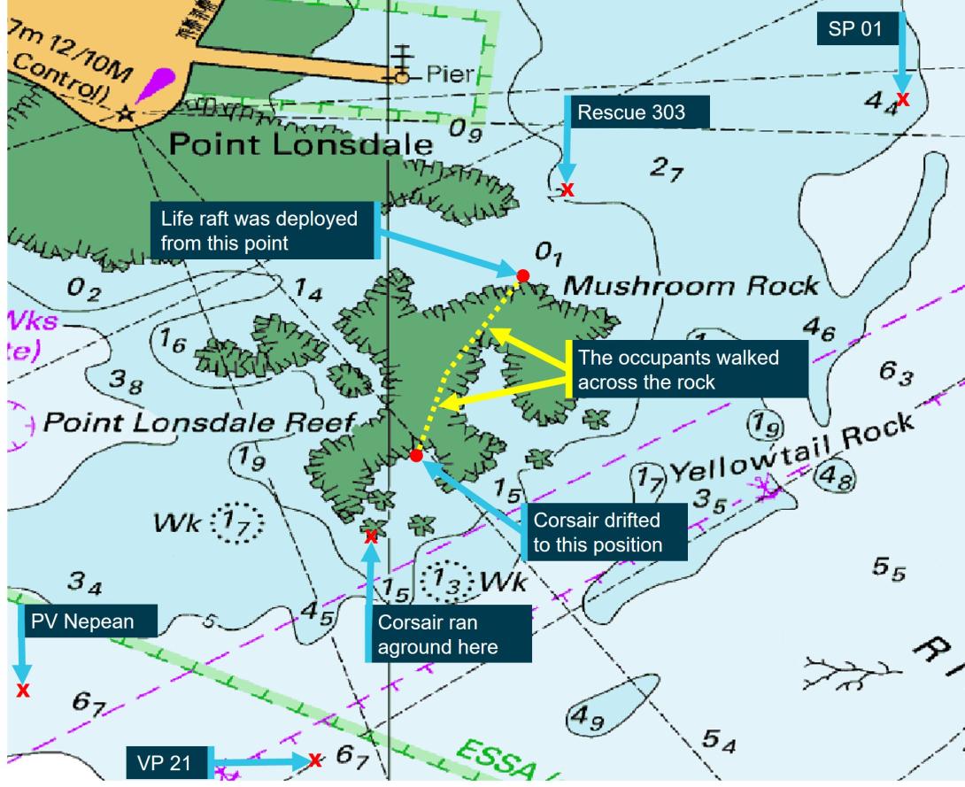
The course alteration to port was completed and the launch steadied on a course of about 052º when Corsair was about 760 m from the reef. At about 2313 Corsair entered the shallowing water and ran aground travelling at about 24 knots (Figure 3).
Figure 3: The track of PV Corsair outbound and then inbound towards the reef
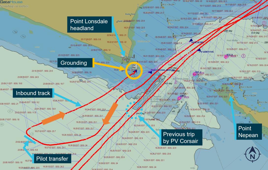
The figure also shows the tracks of PV Corsair through the Heads on its previous trip.
Source: Ports Victoria, annotated by the Office of the Chief Investigator
Rescue operation
After attempts were made by the coxswain to clear Corsair from the reef, the launch became disabled and came to rest in a rock pool about 500 m from Point Lonsdale. On checking the navigational aids, the coxswain realised that they were further west than intended and had run aground on Point Lonsdale Reef.
Several calls were made from Corsair seeking assistance, the first by mobile phone at 2317 to the crew of the sister pilot launch, PV Nepean. A Mayday distress broadcast was then transmitted from Corsair at 2319 on VHF radio Ch 12 directed to Ports Victoria Vessel Traffic Services (VTS) (see Port and waterway management). The caller advised that the launch was taking on water and it was not safe to remain onboard. The 2 crew and the pilot took the life raft and other emergency equipment off the pilot launch and waded onto the reef (cover photo). They inflated the life raft, but sea conditions did not yet allow its launch.
On receipt of the mayday call, the VTS contacted the Victoria Police Search and Rescue Squad (VicPol SAR) at the State Rescue Coordination Centre. VicPol SAR then activated the Australian Volunteer Coast Guard at Queenscliff, the Southern Peninsula Rescue Squad at Blairgowrie, and its own rescue response team. The Mayday call was also heard by PV Griffiths, a pilot launch operated by Auriga Pilots Melbourne and also located at Queenscliff.
PV Nepean was the first to arrive at the scene at about 2350. Four other vessels responded including Coast Guard vessel Rescue 303, the Southern Peninsula vessel SP01, the VicPol SAR vessel VP21. PV Griffiths also responded and was on standby to assist.
The crew and pilot from the PV Corsair made their way to the northern edge of the reef. At around 0130 in improving conditions,[9] they launched the life raft and paddled towards Rescue 303 (Figure 4). At about 0132 Rescue 303 reported that they had taken on board the 2 crew and the pilot and requested that SP01 tow the now empty life raft back to Queenscliff.
Figure 4: Vessels responding to the grounding (PV Griffiths was located further east)
The figure captures the location of responding vessels around the time of rescue, except PV Griffiths which was east of SP01.
Source: Australian Hydrographic Office annotated by the Office of the Chief Investigator
The crew and pilot from Corsair were safely landed at Queenscliff at about 0144. They were assessed by Ambulance Victoria and discharged. There were no reported injuries other than mild hypothermia.
The entrance to Port Phillip was closed to shipping from 0001 to 0210 on 6 October while the rescue was in operation, and again later that morning from 0525 to 1015 while debris from the Corsair was recovered. During the night, the pilot launch had been wrecked by the effect of the sea and reef (Figure 5).
Figure 5: Recovered wheelhouse from PV Corsair
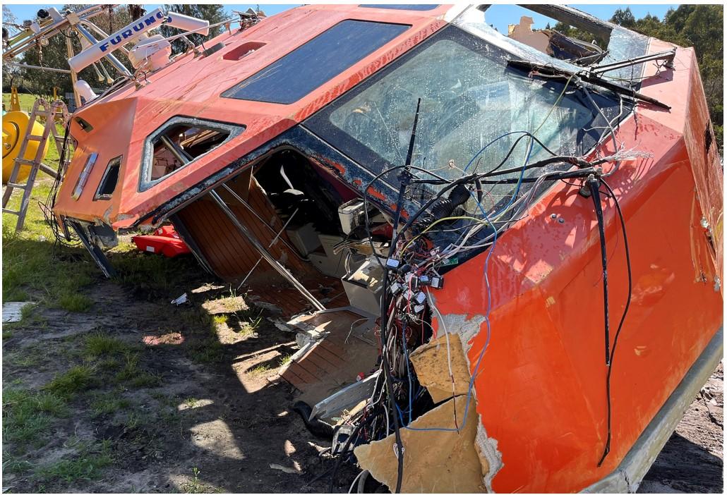
Source: Office of the Chief Investigator
Context
The waterway
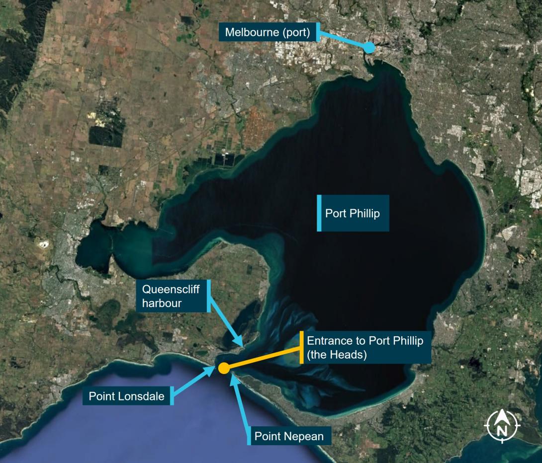
Port Phillip Heads
Port Phillip Heads (the Heads) is the narrow waterway entrance connecting Bass Strait to the bay of Port Phillip. The entrance to Port Phillip is between Point Lonsdale and Point Nepean (Figure 6). The distance between the headlands is about 3.5 km although the outlying reefs significantly reduce the width of navigable water. The width of the entrance between the 5 m depth contour lines is about 1750 m and is about 1000 m between the 10 m contours.
Figure 6: The entrance to Port Phillip
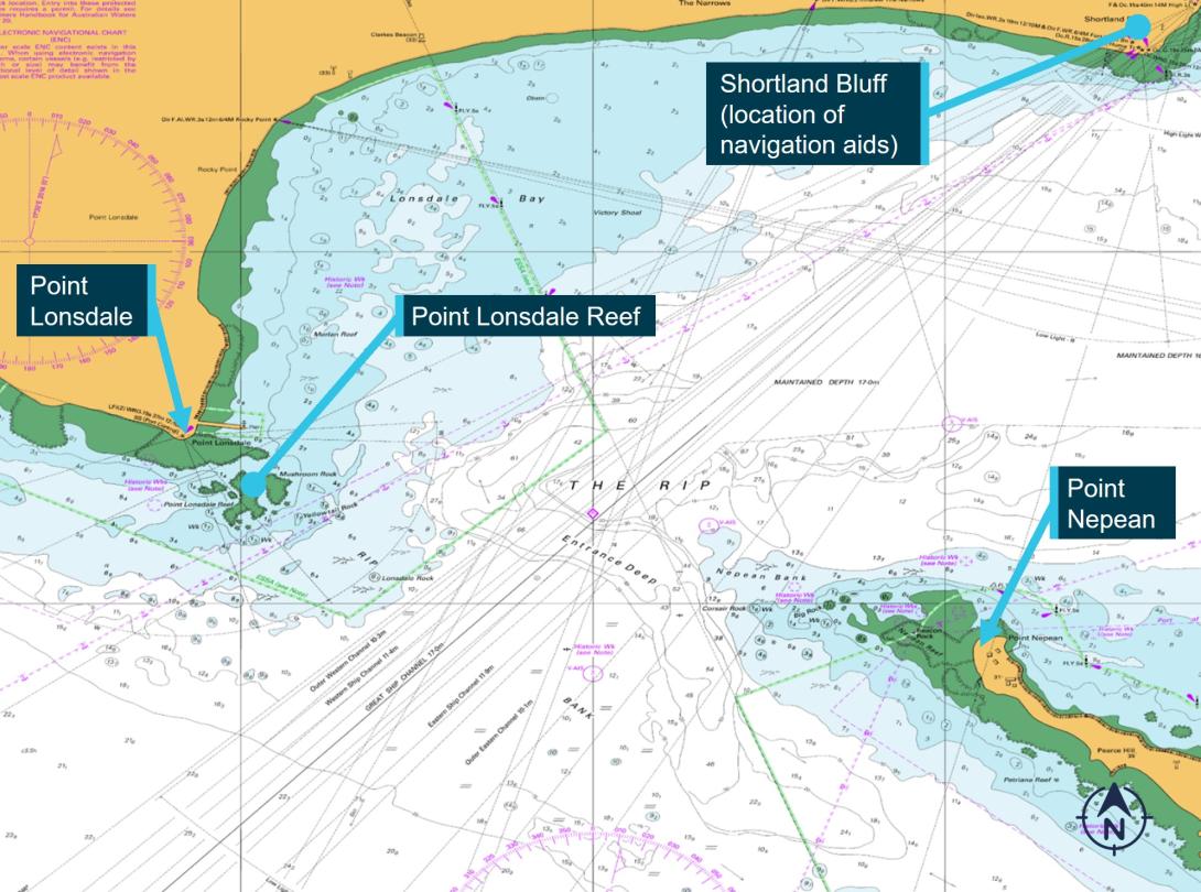
Source: Australian Hydrographic Office, annotated by the Office of the Chief Investigator
Point Lonsdale Reef is an outcrop of flat-topped rock extending about 550 m south-east of the headland of Point Lonsdale. The inner and outer sections of the reef are separated by a narrow channel and both sections are exposed at low tide.
Tidal streams
Due to the narrow entrance and sea floor topography, tidal streams of up to 8 knots can be experienced in the Heads. The strongest tidal streams occur around the time of high water (HW) and low water (LW) at Point Lonsdale. This is due to the lag in the equalisation of the water levels inside and outside the Heads. Slack water occurs around midway between high and low water.
The outgoing stream sets towards the bight between Point Lonsdale and Shortland Bluff (Lonsdale Bay), and thence out through the entrance (Figure 7).
Figure 7: Port Phillip Heads current vector diagram for ebbing tidal flow
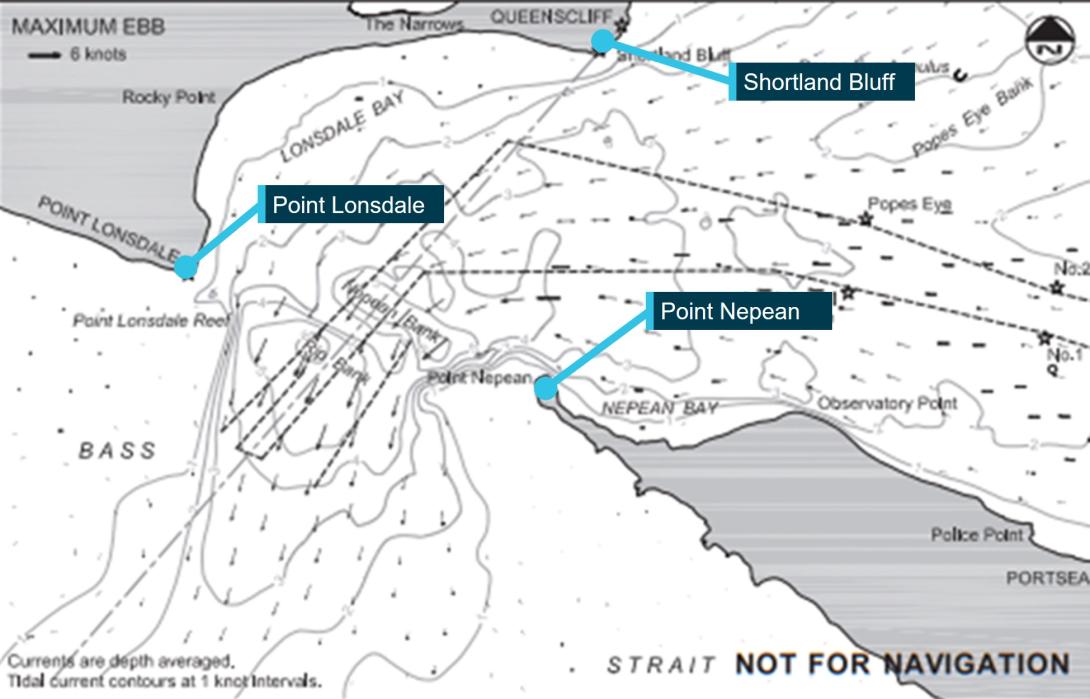
Source: Ports Victoria, annotated by the Office of the Chief Investigator
Strong winds, swell and seas from the south to south‑west sector during an outgoing tidal stream cause higher than usual seas within the Heads and heightened risk to small vessels. Nearer to Point Lonsdale, waters can be comparatively smoother in such conditions. Small craft therefore favour the western side of the entrance to avoid the main tidal flows through the centre and towards the east of the entrance.
Conditions in the entrance at the time of grounding
Corsair was returning to Port Phillip a short time after low water which was at 2249 at the entrance.[10] The height of the tide at the Heads was about 0.6 m above the charted depth and rising. Due to the earlier described lag in water levels equalising inside and outside the Heads, the tidal stream was still running out of the bay (ebbing) at about 5.6 knots. The wind was from the south-south‑west at 22 knots, gusting to 26 knots.[11] The ebbing tide and opposing sea and wind conditions typically produce localised rough seas.[12]
At the time of the grounding, large sections of Point Lonsdale Reef were exposed (Figure 8).
Figure 8: Point Lonsdale Reef with similar conditions to those on 5 October 2023

Source: Office of the Chief Investigator
Navigation through Port Phillip Heads
Aids to navigating through the entrance
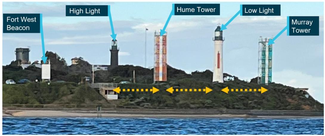
Navigational aids to assist mariners and boaters to navigate through the entrance were located at Shortland Bluff (Figure 9). Point Lonsdale Lighthouse, which is located on the western headland of the entrance, also provided a warning to mariners.[13]
Figure 9: Navigational aids at Shortland Bluff (Queenscliff)
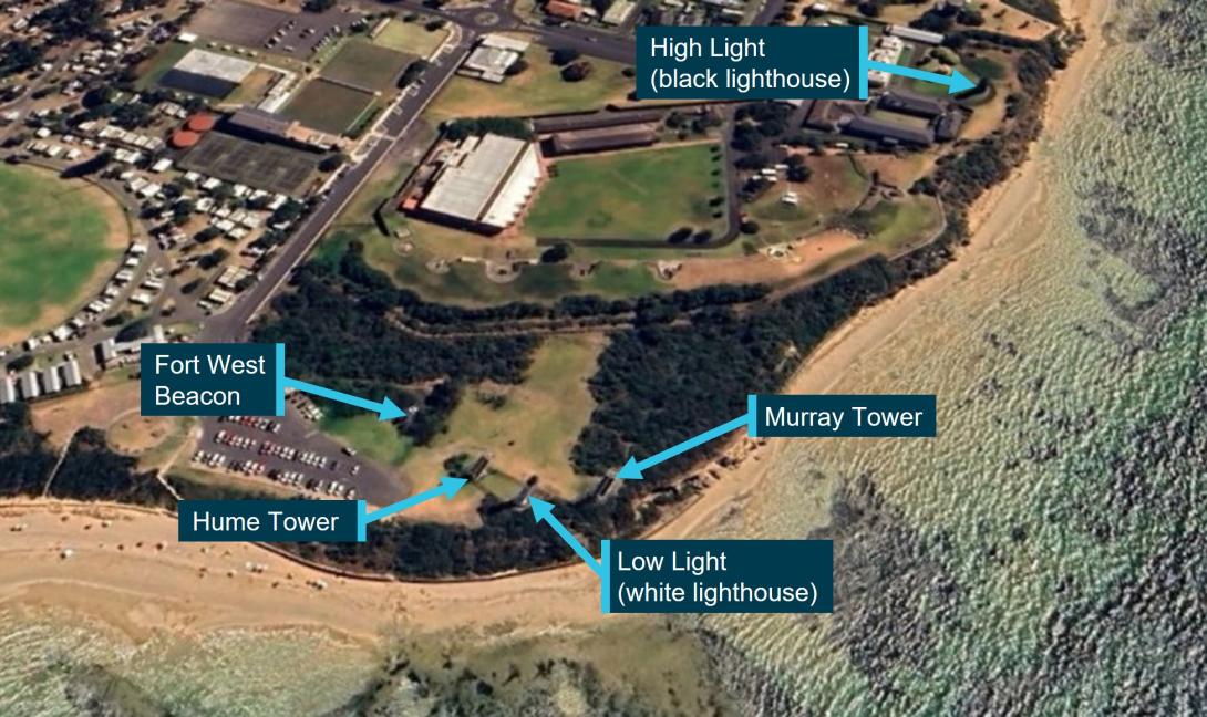
Source: Google Earth © 2024 annotated by the Office of the Chief Investigator
Navigational aids on Shortland Bluff which assist in the navigation of the entrance by small craft are described in Table 1.
Table 1: Navigational aids used to navigate the entrance
| Name | Construction | Approximate height of light(s) above sea level |
| High Light | Black stone tower of 25 m height located about 370 m back from the southern edge of Shortland Bluff. | 40 m |
| Low Light | White stone tower of 25 m height located at Lighthouse Point at the southern end of Shortland Bluff. | 28 m |
| Murray Tower | Green metal framework tower with white vertical stripe, located to the east of the Low Light. | 25 m |
| Hume Tower | Red metal framework tower with white vertical stripe, located to the west of the Low Light. | 28 m |
| Fort West Beacon | Metal framework tower, located further west of Hume Tower. | 19 m (note 1) |
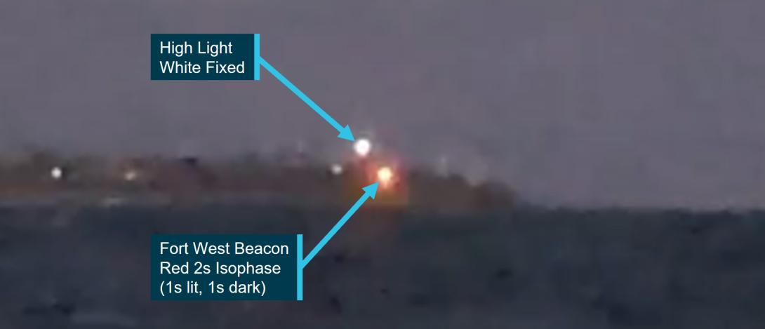
At night, navigational aids are identfied through their location and the characteristics of their lights. When viewed from sea, their relative position and light sectors provide information to masters to assist navigation. The lights on navigational aids located at Shortland Bluff are described in Table 2. All lights had a nominal range exceeding 10 NM except for Murray Tower which had a nominal range of 5 NM.
Table 2: Characteristics of navigational lights to navigate the entrance
| Name | Colour | Sequence | Arc of light visibility (from seaward) |
| High Light (note 1) | white | Fixed | 014° - 059° |
| white | Occulting[14] 15s (12.5s light, 2.5s darkness) | 029° - 053° | |
| Low Light (note 2) | white | Occulting 15s (12.5s light, 2.5s darkness) | 032° - 046° |
| Murray Tower | green | Occulting 15s (12.5s light, 2.5s darkness) | 029° - 049° |
| Hume Tower | red | Occulting 15s (12.5s light, 2.5s darkness) | 036° - 056° |
| Fort West Beacon (note 3) | white | Isophase[15] 2s (1s light, 1s darkness) | 048.7° – 052.7° |
| red | Isophase 2s (1s light, 1s darkness) | 052.7° – 058.7° |
Note 1. The vertical arcs of visibility are different for the fixed and occulting lights. For small craft, the fixed light is dominant.
Note 2. The red and green lights of the Low Light are in sectors not visible to vessels navigating the entrance.
Note 3. Additional lights used by shipping are not included in this table.
Approaches on the west side of the entrance
Introduction
There are several channels designated for the navigation of ships and other vessels through the entrance to Port Phillip. The Outer Western Channel with a declared depth of 10.3 m was the western most designated shipping channel. The Hume Tower in line with the High Light (alignment 046°) marked the western limit of the Outer Western Channel. At night, this presented to small craft as the white High Light over the 15s occulting red light of Hume Tower.
Small craft channels
Smaller craft often used the approaches west of the Outer Western Channel. These shallower approaches included Fisherman’s Channel which ran between the submerged Lonsdale Rock (6.1 m depth) and the submerged Yellowtail Rock (1.7 m depth), and an inner channel with a depth of about 1.4 m running between the inner and outer sections of Lonsdale Reef (Figure 10).
Figure 10: Small craft channels to the west of shipping channels
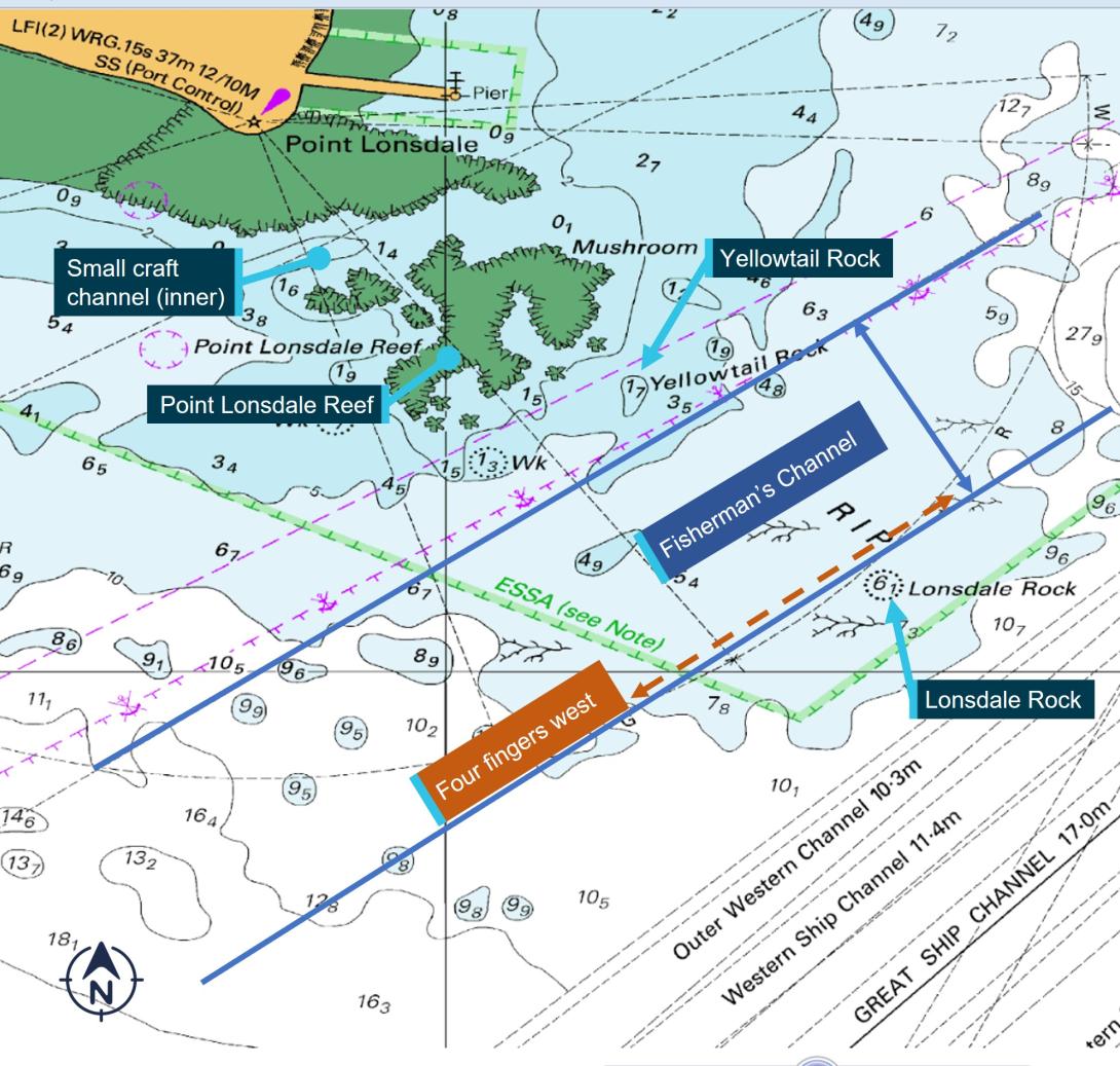
The approximate approach of four fingers west is also marked on this figure (see Four fingers west).
Source: Australian Hydrographic Office annotated by the Office of the Chief Investigator
Navigating Fisherman’s Channel
The sector lights of Fort West Beacon (FWB) were used to navigate within Fisherman’s Channel and to warn operators when they were west of the channel and in unsafe waters. The white sector light (048.7°-052.7°) of FWB indicated the navigable water between Yellowtail Rock and Lonsdale Rock. Its western edge was marked by the limit of its white sector (052.7°).[16] Further west, FWB displayed a red sector light (052.7°-058.7°) indicating an unsafe sector which included the submerged Yellowtail Rock and Point Lonsdale Reef.
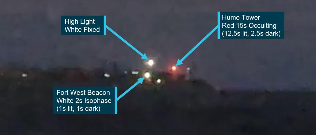
This western limit of Fisherman’s Channel was also indicated by the alignment of Fort West Beacon with the High Light. Safe transit within this small craft channel would therefore be achieved by keeping the High Light to the right of FWB (Figure 11). This approach would keep the High Light between the FWB white isophase light, and the red occulting light of Hume Tower which would also be visible on this approach.
Figure 11: Fisherman’s Channel indicated by the white sector of Fort West Beacon
Source: Office of the Chief Investigator (with contractor)
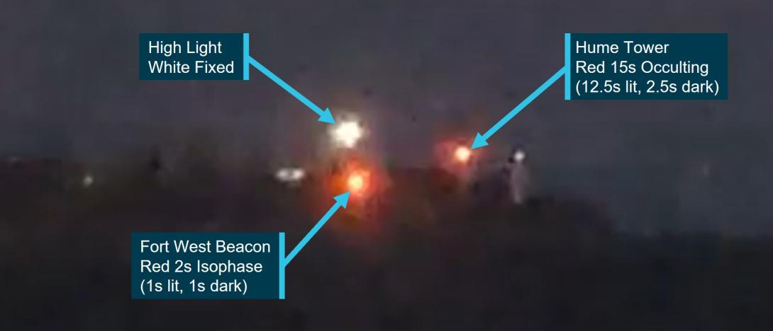
When west of, and outside, Fisherman’s Channel, the High Light would be observed to the left of FWB which would now be in its red sector (Figure 12). Hume Tower would also still be visible in this part of the FWB red sector.
Figure 12: Just west of Fisherman’s Channel in the red sector of Fort West Beason
Source: Office of the Chief Investigator (with contractor)
Four fingers west
Within Fisherman’s Channel, ‘four fingers west’ referred to the approach when maintaining the High Light, Hume Tower, the Low Light and Murray Tower equispaced (Figure 13). West of this approach, the gap between High Light and Hume Tower would widen. Not all lights on these 4 navigational aids were visible from seaward on the four fingers west approach, and therefore this formation was only reliably referenced in daylight.
Figure 13: Four fingers west when High and Low Lights and Towers were equispaced
Source: Office of the Chief Investigator
Approaching the entrance further west of Fisherman’s Channel
Further to the west, the limit of the Hume Tower red occulting light would be reached and no longer seen (Figure 14). Beyond this limit, the navigational aids visible on Shortland Bluff would be the white High Light above, and to the left of, the red sector light of the Fort West Beacon. Corsair was operating around the western limit of the Hume Tower light. Trials suggest that the Hume Tower light was probably not visible to the crew of Corsair during most of its approach.
Figure 14: Further west of Fisherman’s Channel outside the light sector of Hume Tower
Source: Office of the Chief Investigator (with contractor)
Port and waterway management
This occurrence involved ship pilotage services in support of commercial shipping operations. Most of the operations of Corsair were also within the designated port waters of the port of Melbourne. These waters were managed by the statutory authority Ports Victoria.[17]
Ports Victoria had a stated role to provide safe, fair and efficient access to Victoria’s commercial ports through the provision of marine navigation services. Safety management included the engagement of a licensed Harbour Master for each commercial port and the provision of Vessel Traffic Services (VTS) to mariners.
For the southern parts of Port Phillip and designated port waters outside the Heads, traffic services were provided by ‘Lonsdale VTS’ which was co-located with other VTS operations at the Port Operations Centre in Melbourne. Traffic was monitored using electronic charting systems with AIS and radar overlay, and using CCTV installed at Point Lonsdale and Point Nepean.
The pilotage transfer operations of Corsair were part of port operations. In accordance with safety requirements for port waters,[18] the coxswain of Corsair was required to inform Lonsdale VTS of their departure and the nature of their work, which they did. VTS subsequently monitored the movements of the outbound Rio Grande and Corsair during the pilot transfer. Protocol was for pilots to disembark outbound ships 2 to 5 NM to seaward of the entrance and the pilot transfer from Rio Grande to Corsair was consistent with this protocol.
Once Corsair turned away from Rio Grande and started their return trip, there was no requirement for Corsair to report their in-coming trip to VTS and VTS were not aware of the intended passage of Corsair. Corsair subsequently grounded outside designated commercial port waters.
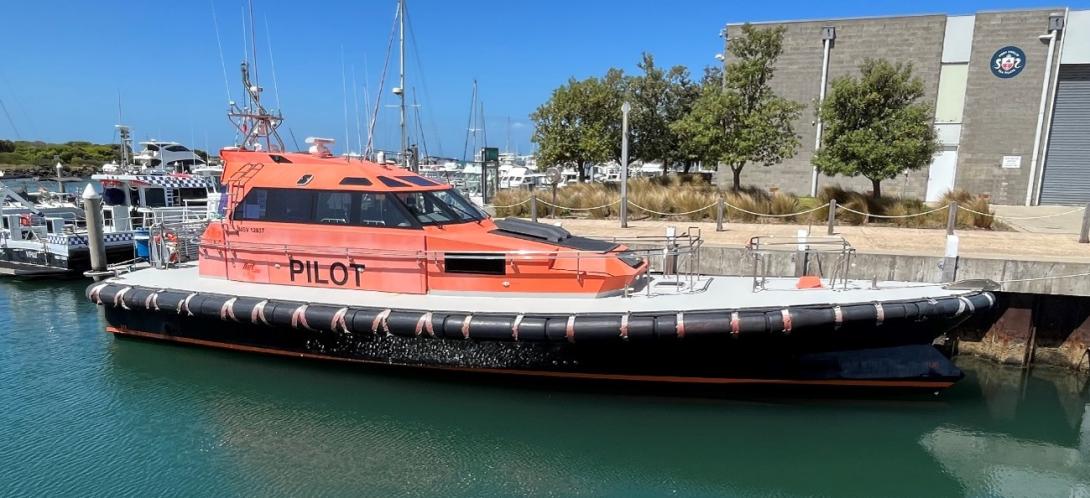
Pilot launch PV Corsair
Overview
PV Corsair was used for transporting marine pilots from the PPSP pilot station at Queenscliff to inbound ships requiring pilotage to enter port waters, and to retrieve pilots who had piloted ships which were departing port waters. Its sister vessel of the same class was the PV Nepean (Figure 15).
Figure 15: PV Nepean of the same design and construction as Corsair
Source: Office of the Chief Investigator
Corsair was constructed in 2014 by Hart Marine in Mornington, Victoria. It was of monohull design with an overall length of 18.6 m, breadth of 5.5 m, depth of 2.3 m and had a draft of about 1.6 m. Propulsion was by two Cummins marine diesel engines for a maximum speed of about 30 knots.
The vessel was constructed to the requirements of Bureau Veritas[19] and the Australian National Standard for Commercial Vessels (NSCV) [20] for a Class 2C[21] vessel.
Corsair was registered with the Australian Maritime Safety Authority (AMSA) as a domestic commercial vessel (DCV). It had a Certificate of Survey valid until 28 May 2025 and a Certificate of Operations valid until 2 September 2024. The AMSA certificates permitted Corsair to operate as a pilot vessel with a crew of 2 and up to 6 special personnel.[22] Corsair’s certification was for a non‑passenger‑carrying vessel.
At the time of the grounding, the operation of the launch was consistent with its certification. The vessel was appropriately crewed and was transporting one special personnel (the pilot). The pilot was not involved with the navigation of the launch and was not required to be involved.
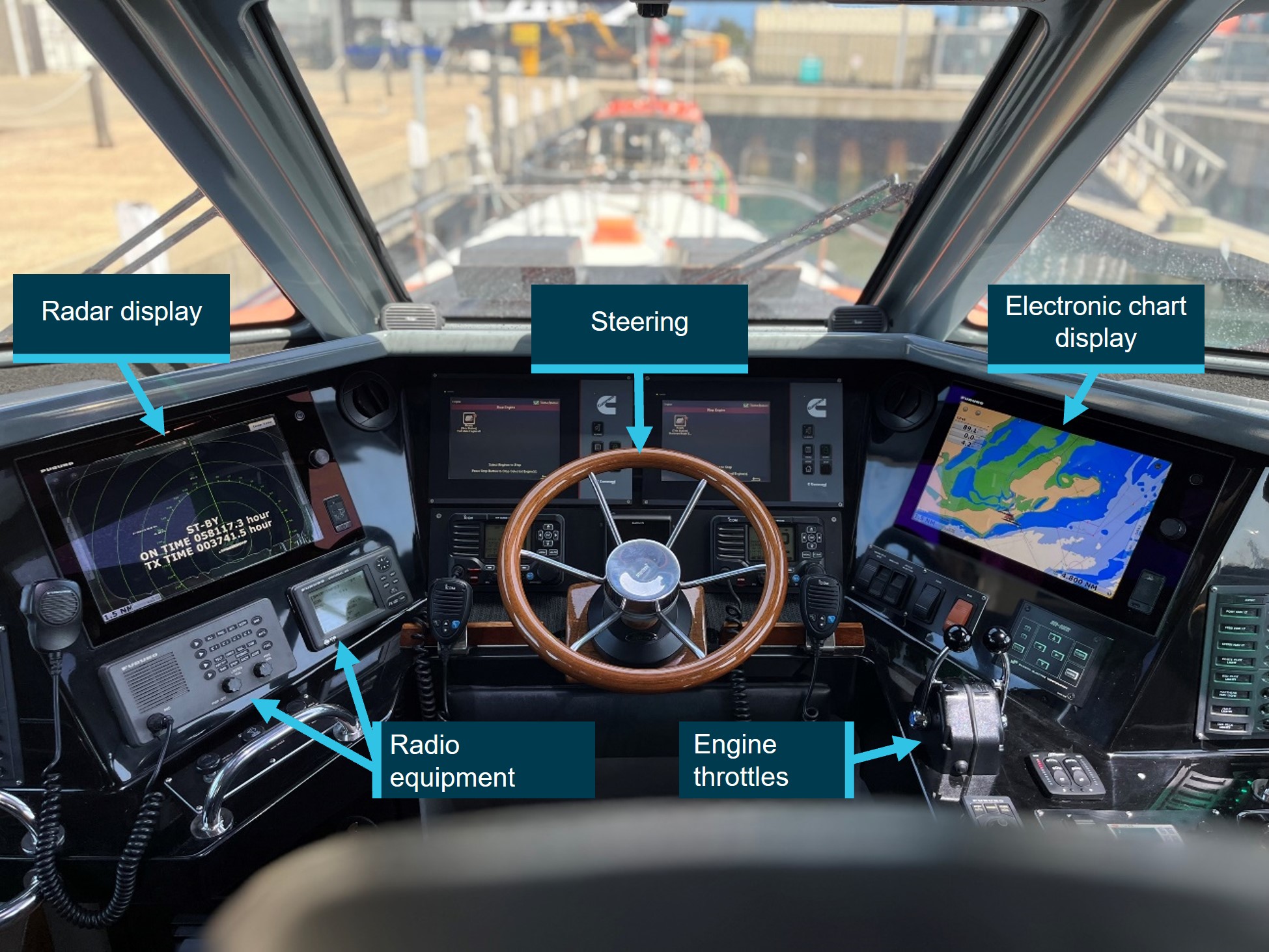
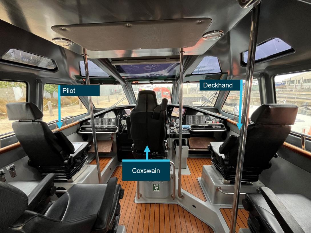
Conning position
The coxswain navigated the launch from the forward position in the wheelhouse. For the return journey of Corsair on the night of the grounding, the deckhand was seated to the right of the coxswain and the returning pilot was seated to the left (Figure 16). The deckhand reported not having a clear view of the navigation displays from their position.
Figure 16: Cabin layout of Corsair and personnel positions (photographed on Nepean)
Source: Office of the Chief Investigator
Navigation equipment
Overview
PV Corsair was fitted with a Furuno Navnet 3D Navigation system incorporating an electronic chart plotter and radar displayed on the 2 multi-function (interchangeable) display units, one on each side of the conning position (Figure 17). The displays on Corsair were configured with the chart plotter to the right, and the radar display to the left of the coxswain’s chair and both were dimmed for night operations on the night of the grounding. A third display unit located to the rear of the cabin could be used to replicate either of the navigational console displays, although it was mainly used to log events and check weather.
A GPS unit, a depth sounder and an Automatic Identification System (AIS)[23] unit with separate display screen was integrated into the Navnet 3D system, allowing position information, sea depth information and AIS targets to be displayed. Communications equipment comprised 2 mounted and 2 portable VHF radios.
Figure 17: Configuration of navigation equipment on Corsair (photographed on Nepean)
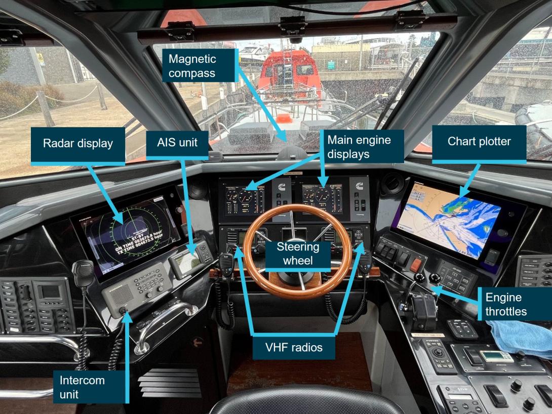
Wheelhouse configuration on PV Nepean, which was similar to the configuration on PV Corsair.
Source: Office of the Chief Investigator
Chart plotter options and configuration
The chart plotter was loaded with electronic charts for the relevant waterways and the integrated GPS unit provided launch position information. The radar image could be overlaid on the chart plotter and information from the AIS unit displayed on the chart screen. The chart plotter was set to 6 NM at the time of the grounding.
The vessel’s heading vector indicating the direction in which the launch was heading was shown on the chart plotter. The length of the vector was determined by a time variable set by the coxswain. The coxswain advised that on Corsair the heading vector had been set to 10 minutes. This equated to a length of 4 NM if travelling at 24 knots, and 3.5 NM if travelling at 21 knots.
Chart plotter features not used on the night of the grounding included:
- storage and display of waypoints[24]
- designation of ‘no-go’ zones (areas dangerous to surface navigation) by enabling depth shading overlays to highlight shallow water areas and contrastingly, safe navigable areas.
Radar display options and configuration
The radar was a conventional X-band marine radar, incorporating ARPA (automatic radar plotting aid). It had a maximum detection range of 24 NM. The GPS and AIS were also integrated into the radar display. AIS targets could be displayed on the radar. The coxswain advised that the radar display was set to 6 NM.
When operating, the ship’s heading marker extended from the centre of the radar plot (the launch’s position) to the edge of the screen. This served to provide visual warning of any objects in the path of the ship.
The radar had an option to set up a variable range marker (VRM).[25] The VRM could be used to maintain a pre-determined distance off a radar target, a navigational practice sometimes used when rounding points of land or navigational marks. The option to set up guard zones[26] was not available.
Radar (transmission and detection) works by direct line of sight between the radar scanner and an object. The radar had a ‘Gain’ control to reduce the clutter[27] from heavy rain and/or rough seas. However, radar clutter can get sufficiently dense to hide low-lying real objects like small boats and low-lying rocks. While the edge of land at Point Lonsdale would have been clearly visibly on the radar display, the outlying Point Lonsdale Reef being at water level may not have been detected by the radar.
On board recordings
Data storage devices for navigation displays were recovered from the wreckage. However, usable data could not be retrieved due to the damage sustained.
Recovered CCTV footage from Corsair was of poor quality with limited forward vision of navigational lights. Footage did confirm operation of the radar on the vessel’s return journey to the entrance.
Crew of Corsair
Coxswain
The coxswain of Corsair had about 10 years on-water marine experience with PPSP, initially as a deckhand before progressing through coxswain training and becoming an unrestricted launch coxswain in March 2021.
The coxswain held the necessary marine certification to master Corsair. They held a Certificate of Competency as Master <24m NC and a Certificate of Competency as Marine Engine Driver Grade 2 NC, both valid to September 2026. Medical certification was valid to December 2023.[28]
The coxswain also held the waterway certification required by regulator Safe Transport Victoria (see Local knowledge regulation for vessel operators). They held a Local Knowledge Certificate for Port Phillip Bay South valid until October 2027. The coxswain did not hold a Certificate of Local Knowledge for Port Phillip Heads and was not required to hold that certificate.
Deckhand
The deckhand had about 26 years maritime experience, commencing as a deckhand on fishing and charter vessels in Queensland, and then continuing in Victoria from about 2004. They joined PPSP in early 2018 and successfully completed their induction training as deckhand in July 2018 and had been working on pilot launches since.
The deckhand also held a Certificate of Competency as Master <24m NC valid to March 2027, a Certificate of Competency as Marine Engine Driver Grade 2 NC valid to October 2026 and a Local Knowledge Certificate for Port Phillip Bay South valid to November 2025. Medical certification was valid to August 2024.
Port Phillip Sea Pilots
Introduction
Corsair was owned and operated by pilotage service provider Port Phillip Sea Pilots (PPSP). PPSP was established in Victoria in 1839 and was licensed to provide pilotage services in the Victorian ports of Melbourne, Geelong, Hastings and Corner Inlet. It also provided relief pilots to the Port of Portland.
The transfer of pilots to inbound ships, and from outbound ships was managed from its Queenscliff base. Local facilities included launch berths and maintenance workshops at Queenscliff harbour, a Pilot Station incorporating the PPSP Operations Centre, and a jetty for the launch to pick-up and drop-off pilots (Figure 18). The coordination of launch and pilot availability was managed by pilot despatch officers working from the Operations Centre.
Figure 18: Location of PPSP pilot station and jetty in Queenscliff
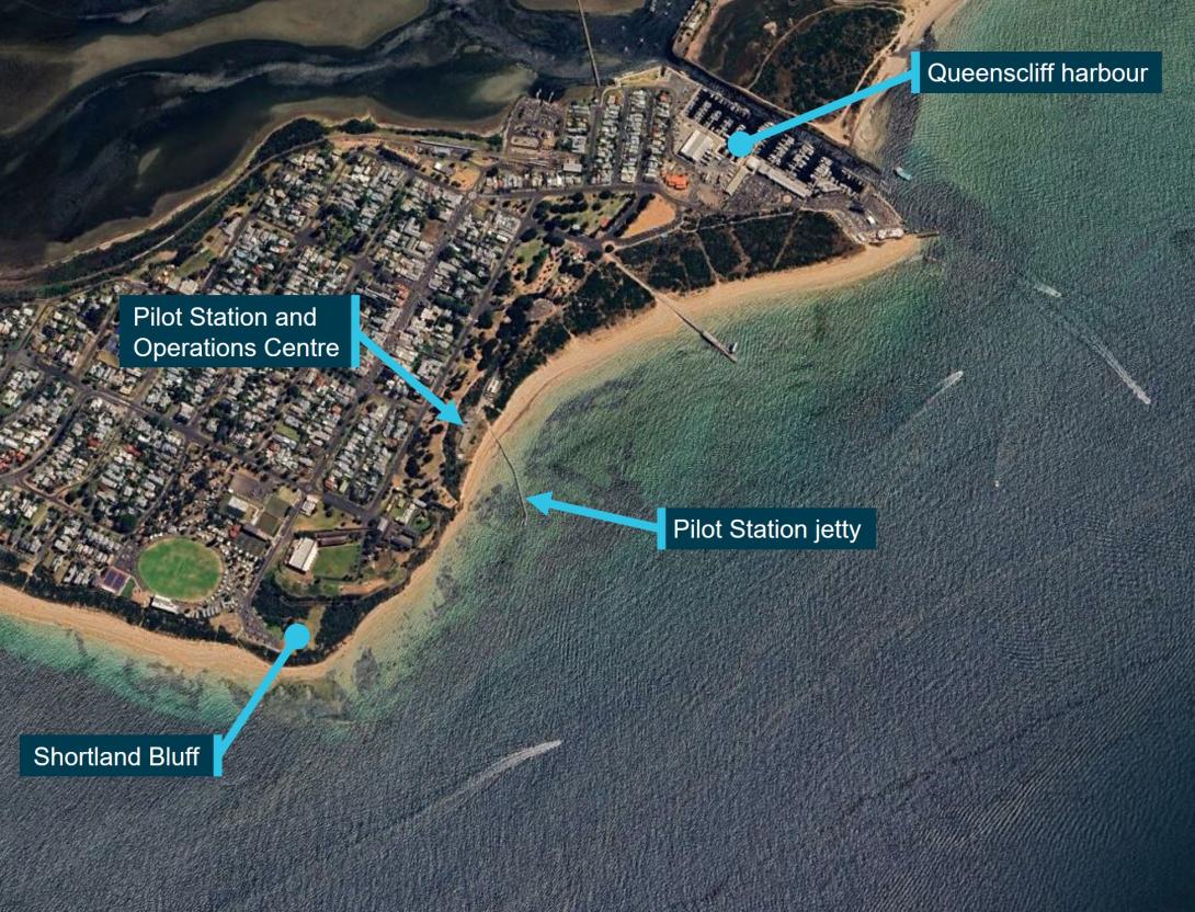
Source: Google Earth © 2024 annotated by the Office of the Chief Investigator
Launch safety management system
Obtaining a vessel Certificate of Operations required the launch to have a Safety Management System (SMS) that complied with AMSA Marine Order 504[29] (MO 504). An SMS provides the structures and guidance to support the safe management of a vessel during routine operations and in the case of emergency.
The scope of the developed vessel SMS manual[30] for the pilot launch was consistent with the scope of MO 504 and included sections on:[31]
- contact details
- risk assessment
- owner’s responsibility and authority statement
- designated person
- coxswain responsibility and authority statement
- resources and personnel (including crewing)
- procedures for onboard operations
- emergency preparedness
- follow-up on hazardous occurrences and non-conformance
- maintenance of vessel and equipment
- documentation
- verification, review and evaluation.
The vessel SMS section on procedures for onboard operations referred to the PPSP integrated management system and document QP07.3 Launch Operations.[32] QP07.3 included a wide range of standard operating procedures covering normal operations (including pilot transfer) and emergency scenarios. The manual did not include guidance on voyage planning for transiting Port Phillip Heads, use of navigational equipment[33] or launch resource management (see Safety analysis, Use of available resources).
The detail of a safety management system is scoped based on an assessment of risks for the vessel’s operations. MO 504 specified that procedures for onboard operations be ‘developed for key onboard operations to address any risks identified by the risk assessment’. The concept of reducing risk so far as is reasonably practicable was also established in the marine order.
PPSP had undertaken risk assessment of its launch operations. Launch grounding and associated controls were identified in 2 scenarios:
- launch runs aground during operations [risk controls included: launch navigation equipment]
- launch grounding due to severe weather [risk controls included: crew operations procedures].
Coxswain training
Overview
Coxswain selection, training and record keeping was described across a number of documents including the vessel SMS, the Launch Operations procedures manual and a detailed training checklist which also included a trip record table and sign-off.
The coxswain training program involved three stages. The program included a range of topics and skills at each stage, although it did not include supporting course notes or training guidelines. The check-off lists included space to record ‘competent’ or ‘not yet competent’ against each competency. The criteria for assessment of competencies were not detailed.
Progression through each stage of training required sign-off by other coxswains. Documentation was inconsistent and specified sign-off by most, a majority or 3 coxswains between each stage of training. Sign-off by 3 senior coxswains was probably the intention. Final approval included sign‑off by the Managing Director (MD) and the boat repair depot (BRD) manager, and in some documentation the service and compliance manager (SCM).
Basic Training (Stage 1)
In relation to navigating through Port Phillip Heads, the trainee received instruction and was required to demonstrate competency in:
- understanding all leading lights for Port Phillip Heads (PPH)
- understanding PPH transit in different weather conditions
- preliminary PPH transit.
Advanced Training (Stage 2)
This stage involved achieving competencies in technical and practical skills. In relation to launch navigation equipment, the trainee was required to demonstrate competency in:
- AIS unit operation
- electronic chart operations
- radar operations.
Stage 2 training also included the coxswain’s demonstration of practical skills in transiting Port Phillip Heads under a variety of weather and tidal conditions, day and night. A pre‑requisite for progression to Stage 3 required the trainee to be declared competent in transiting Port Phillip Heads.
Advanced Training (Stage 3)
This stage required trainees to conduct launch operation independently under the supervision of the duty coxswain, with a minimum of 20 day transfers and 20 night transfers. On successful completion, the trainee was required to complete at least 30 day transfers as relief Coxswain (unsupervised). Approval by the MD and BRD Manager was required prior to the coxswain being permitted to undertake nightshift duties.
Training documentation suggested that final sign-off was typically by the MD, the BRD manager, the mentor coxswain and 2 other coxswains.
Training records for the coxswain of Corsair
The coxswain’s training logs included entries spanning the period from July 2016 to October 2020. Entries were for training under a range of senior coxswains. Review of log sheets identified records of sign-off by 4 coxswains for progression from Stage 1 to Stage 2, and sign-off by 1 coxswain for progression from Stage 2 to Stage 3. Records were not identified from Stage 3 indicating final sign-off by other coxswains or the BRD manager. Sign-off of the coxswain of Corsair was recorded in MD correspondence in March 2021.
Deckhand training and responsibilities
The position description for deckhands specified that deckhands should have broad practical marine skills with experience working on launches. Although not mandatory, formal marine qualifications were considered an advantage.
Procedures described completion of appropriate on-the-job training and referenced the deckhand induction checklist. The induction training consisted of deckhand familiarisation with routine and emergency vessel procedures, the location and use of emergency equipment, and knowledge of company policies. The deckhand of Corsair had completed the induction.
Deckhand responsibilities included keeping a lookout while the launch was underway. Procedures did not detail any specific involvement in navigation or passage planning with the coxswain.
Local knowledge regulation for vessel operators
Introduction
Safe Transport Victoria (STV) is the Victorian transport safety regulator. Its scope includes some coverage of marine operations on Victorian waters. For several designated Victorian waterways, STV specified requirements for operators of domestic commercial vessels to have STV issued local knowledge certification to complement national maritime qualifications. Local knowledge certification did not apply to vessels requiring a pilot or a pilotage exempt master.
Local knowledge areas relevant to Corsair operations
Corsair operated in local knowledge areas 15 (LK15) and 16 (LK16) for its operations between Queenscliff harbour and outside the Heads (Figure 19). LK 15 included the designated hazardous area of Port Phillip Heads and some additional adjoining waters.[34] LK16 extended north from LK15 and was designated Port Phillip Bay South.[35]
Figure 19: Designated local knowledge areas LK15 and LK16
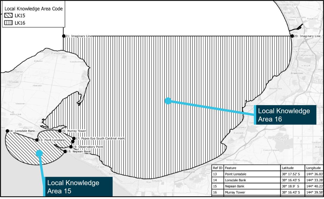
Source: Safe Transport Victoria, annotated by the Office of the Chief Investigator
Certification requirements for masters of vessels in LK16
The master of a trading vessel (passenger and non-passenger) of greater than 12 m in length was required to hold a local knowledge certificate when operating in LK16 waters. This requirement therefore applied to the operation of Corsair and the launch coxswain was suitably certified. Assessment for LK16 did not cover vessel operations and navigation through Port Phillip Heads.[36]
Certification requirements for masters of vessels in LK15
There was no local knowledge certification requirement for masters of non-passenger trading vessels operating in LK15 waters. This differed from LK16 and several other local knowledge areas. Corsair was certified to operate with special personnel only[37] and was therefore a non‑passenger‑carrying vessel. Local knowledge requirements therefore did not apply to the master of Corsair and its coxswain was not required to hold (and did not hold) a certificate of local knowledge when operating Corsair in LK15 waters.
LK15 requirements only applied to masters of passenger-carrying trading vessels of greater than 12 m in length. There was no requirement for local knowledge certification for masters of passenger vessels of 12 m or less.
Training and assessment for a local knowledge certificate for LK15
STV specified the requirements for local knowledge certification for LK15.[38] The candidate was required to complete an approved training course. Marine Training Services (MTS) in Geelong was the (only) trainer accredited by STV for LK15 training. Its course involved theory and practical components which included tidal, weather and sea conditions, vessel handing, emergency procedures and navigation through the entrance. Assessment included written and oral examinations.
Safety analysis
Introduction
On the night of 5 October 2023, the pilot aboard Rio Grande disembarked and transferred to Corsair at a position approximately 2.25 NM (4.2 km) south‑west of Point Lonsdale. Following pilot transfer to the launch, Corsair commenced its return to Queenscliff. On their return, Corsair was navigated to the west of the usual passage through the Heads and grounded on Point Lonsdale Reef.
This analysis discusses:
- the circumstances and factors influencing the navigational error
- the use of available resources to reduce the likelihood of error
- launch safety management system
- crew training
- local knowledge requirements.
The circumstances and factors influencing the navigational error
Local conditions
The operational parameters on the evening of the grounding were not unusual. However, on this night, pilot retrieval and the starting point for the return journey to the entrance was further west than most recent passages (Figure 20). This westerly position and the need to initially navigate east for an extended duration for a more central approach to the entrance may not have been recognised by the launch coxswain.
Figure 20: Passages of Corsair in last 14 days including on the evening of grounding
Source: Port Phillip Sea Pilots, annotated by the Office of the Chief Investigator
The environmental conditions on the evening of the grounding were also not unusual. However, the prevailing winds, seas and opposing ebb tide led to rough conditions which may have influenced the crew’s view towards the navigational aids located on Shortland Bluff.
The error in navigation
The coxswain’s intention was to initially head towards the entrance until they picked up the lead for the western limit of the Outer West Channel (the white High Light over the Hume Tower occulting red light), then slowly alter course to port for an approach within the small craft channels. The coxswain indicated that their intention was to use the four fingers west approach.
The coxswain reported observing a red light below the High Light. It is probable that the coxswain believed themselves to be near the lead for the Outer West Channel during this phase of the approach and altered their course by about 18° to port in this belief. However, the red light of their focus was very likely to have been the red sector isophase light of the Fort West Beacon rather than the Hume Tower occulting red light. It is possible that the rough seas may have affected the coxswain’s observation of lights from the navigational aids on Shortland Bluff.
Retrieval and return of the pilot to Queenscliff was a routine activity that had been performed by the crew of the Corsair many times and in a range of environmental conditions. Repetitive experience can induce a sense of routine, safety, and normality in an otherwise risky environment (Schager 2008). A sense of routine and complacency probably influenced the coxswain’s state of mind, their reliance on visual cues for navigation and their limited use of the available navigation equipment. Schager (2008) describes that:
Complacency is a passive state, not an active one, and no one chooses to be complacent. It creeps into one’s mind imperceptibly. Individuals are therefore unaware of being complacent and would, if asked, reassuringly deny it. Instead, individuals would probably justify their state of mind as rational, realistic, reasonable and in line with situational requirements, as well as a sign of experience.
The coxswain’s misinterpretation of the navigational aid light was probably influenced by expectation and confirmation bias. Grech et al (2008) describes the role of expectation bias in our perception system:
Our senses – seeing, hearing and feeling – constantly give us inputs. These inputs are processed in our perceptual system. The perceptual system has, just like our senses, certain limitations and weaknesses. The fundamental function of the system is to process sensory inputs on the basis of our experience, motivations, and knowledge. This mechanism is very useful because it gives us the ability to perceive more with increasing knowledge and experience. But it also has some important drawbacks: humans suffer from what is called expectation bias. This means that if we expect to recognize a certain object we will do so even if the object has changed and, perhaps, even if it is missing.
Grech et al (2008) also describes the role of confirmation bias:
Confirmation bias is when we perceive only the information that can confirm our assumption and discard any information falsifying that assumption. Confirmation bias can be a serious threat to safety when the assumption is that a vessel is right on track and everything is working well. Important danger signals are neglected simply because they do not fit with the assumption, and observations confirming the assumption will be overemphasized.
The coxswain probably believed they were on a routine and more central approach to the entrance. For such an approach, they would expect to see the white High Light over the red Hume Tower Light to mark the western edge of the Outer West Channel. This experience probably influenced their interpretation of the observed white over red lights (expectation bias) and them not perceiving the isophase characteristics of the Fort West Beacon red light (confirmation bias).
There was no evidence identified to suggest that fatigue or distraction influenced or contributed to the navigational error.
Use of available resources
Introduction
The likelihood of human error can be reduced by using protective systems of technology, crew, and procedure. The documented study and application of resource management to protect against human error was explored in the aviation sector as cockpit (and then crew) resource management (CRM). Available resources for effective CRM included information, equipment and people. The aim of these studies was to reduce human error and improve safety through an understanding of human capabilities, human limitations and the way people interact with their work environment and other people.
Such resource management in maritime transport is referred to as Bridge Resource Management (BRM). BRM in a ship context can be defined as the effective management and utilisation of all resources, human and technical, available to the bridge team to ensure the safe completion of the vessel’s voyage.[39] BRM provides a method of organising the best use of these resources to reduce the level of operational risk. It establishes defences against single-person errors. Although much of the maritime literature refers to ship applications, the principle of using all available resources including information, equipment and people is valid for vessels of any size.
Navigation equipment
Active use of navigation equipment to mitigate the risk of human error
The chart plotter was set to a 6 NM range and the heading vector length set to 10 minutes. This setting provided the coxswain with an estimate of the vessel’s course over the next 3.5 NM (with a speed of 21 knots) to 4 NM (with a speed of 24 knots).
The radar display was also set to a 6 NM range. The radar heading marker extending from the centre of the plot (the vessel’s position) to the edge of the screen would indicate the likely path of the vessel over the next 6 NM.
When on a heading of 070° on their return, Corsair was about 1.25 NM (2.3 km) from Point Lonsdale and on a course to clear the reef. A slow course alteration to port subsequently placed Corsair on a heading towards the reef. It is probable that the coxswain did not effectively observe the navigation displays during or after completion of the alteration of course and instead relied on their visual observations of navigational aids at Shortland Bluff.
|
Contributing factor |
Configuration of navigational equipment
Equipment is considered part of the bridge team (Norris 2014). The way in which users interact with the equipment is known as the human machine interface (HMI). The HMI covers such things as displays, menus, switches, controls and audio signals.
The equipment on Corsair had additional capabilities that may have assisted navigation through the Heads. The following are examples:
- Way points and no-go zones could be stored and displayed on the chart plotter. A single waypoint could be used to mark a safe point in the entrance, and stored no-go zones could demarcate unsafe areas.
- The variable range marker (VRM) on the radar or chart plotter could be used to define a preset range for clearance between Corsair and a point such as Point Lonsdale.
|
Other finding The navigation equipment on Corsair had additional (unused) features that could assist launch navigation through Port Phillip Heads. |
The deckhand as a resource
Resource management to reduce the risk of human error encompasses the utilisation of other crew members, in this case the deckhand. Although the role of the deckhand included acting as a lookout, it was probably not normal practice for launch deckhands to be actively involved in passage planning and navigation. In addition, the layout of the navigational displays did not provide for easy monitoring by the deckhand.
|
Other factor that increased risk It was probably not normal practice for launch deckhands to actively support launch navigation. In addition, the layout of navigation displays on Corsair did not allow for easy referral by the deckhand. |
Launch safety management system
An effective safety management system (SMS) includes operational guidance to manage identified risks. Port Phillip Sea Pilots (PPSP) had established an SMS and launch operations procedures for their pilot launches. However, risk assessments did not clearly identify the potential hazard of coxswain navigational error when transiting the Heads and procedural risk controls did not include:
- guidance on the safe navigation of Port Phillip Heads including the use of small craft channels
- instruction and guidance on the effective use of launch navigational equipment to reduce the likelihood of navigational error
- guidance on the role of the launch deckhand in supporting safe navigation.
|
Other factor that increased risk |
Coxswain training
Launch coxswain training involved a 3-stage program. Training was delivered on-the-job by senior coxswains following a checklist of required technical and practical skills. Although transiting Port Phillip Heads was a central part of coxswain training, training scope in passage planning and the effective use of launch resources to reduce the likelihood of errors was not clearly documented. The absence of formal course materials and assessment criteria increased the potential for inconsistency in training delivery and outcomes in the adoption of standard operating procedures for navigating Port Phillip Heads. In addition, the training program did not include a refresher component for navigational practices.
For the coxswain of Corsair, there were gaps in records for the staged sign-off of the coxswain during training. In the absence of other documented training assessment criteria and records, the procedural requirements for sign-off by senior coxswains was an important part of the assurance process.
|
Other factor that increased risk |
Local knowledge requirements for Port Phillip Heads
Small commercial non-passenger-carrying operations
The coxswain of Corsair was not required to hold a Safe Transport Victoria (STV) issued local knowledge certificate for operations in Port Phillip Heads and did not hold such a certificate. Given the extensive experience of the coxswain in these waters, the absence of this certification is not considered to have influenced this occurrence. However, aspects of the regulatory framework were inconsistent, suggesting opportunities for further review by STV.
In the majority of gazetted local knowledge areas, a certificate of local knowledge was required for non-passenger-carrying trading vessels over 12 m in length. However, in the local knowledge area of Port Phillip Heads, masters of non-passenger-carrying vessels were not required to hold a certificate of local knowledge.
|
Other finding |
Passenger-carrying operations
Local knowledge certification was required for passenger-carrying trading vessels over 12 m in length operating in Port Phillip Heads. This regulatory requirement was in recognition of the heightened risks associated with the designated hazardous area of Port Phillip Heads.[40] Passenger-carrying vessels of 12 m and below were not required to hold such certification.
Small passenger vessels are exposed to significant safety risks when operating in these waters. Considering also the capsize of a 10.5 m commercial fishing charter vessel and resulting passenger fatality in 2010, there was an opportunity to further consider local knowledge certification requirements for passenger‑carrying commercial vessels below the current length threshold.[41]
|
Other finding Regulation did not require local knowledge certification of masters of passenger-carrying domestic commercial vessels (DCV) of 12 m and below operating in the high-risk area of Port Phillip Heads. There was an opportunity for Safe Transport Victoria to review this requirement given the risks associated with smaller passenger-carrying vessels and a previous fatal incident of an under 12 m passenger‑carrying DCV in this area. |
Findings
|
ATSB investigation report findings focus on safety factors (that is, events and conditions that increase risk). Safety factors include ‘contributing factors’ and ‘other factors that increased risk’ (that is, factors that did not meet the definition of a contributing factor for this occurrence but were still considered important to include in the report for the purpose of increasing awareness and enhancing safety). In addition, ‘other findings’ may be included to provide important information about topics other than safety factors. Safety issues are highlighted in bold to emphasise their importance. A safety issue is a safety factor that (a) can reasonably be regarded as having the potential to adversely affect the safety of future operations, and (b) is a characteristic of an organisation or a system, rather than a characteristic of a specific individual, or characteristic of an operating environment at a specific point in time. These findings should not be read as apportioning blame or liability to any organisation or individual. |
The following findings are made with respect to the grounding of pilot launch PV Corsair at Port Phillip Heads (near Point Lonsdale), Victoria on 5 October 2023.
Contributing factors
- The launch coxswain misinterpreted navigational aids marking the entry to Port Phillip and navigated to the west of safe passage through the entrance. The coxswain had transited the Heads many times and their perceptions were probably influenced by the expectations of what they would normally observe.
- The launch coxswain relied on their visual observations of navigational aids and did not make effective use of available on-board navigational equipment for the return of Corsair through the entrance to Port Phillip.
Other factors that increased risk
- It was probably not normal practice for launch deckhands to actively support launch navigation. In addition, the layout of navigation displays on Corsair did not allow for easy referral by the deckhand.
- The safety management system for Corsair did not include detailed guidance and reference material for the safe navigation of Port Phillip Heads, the effective use of launch navigational equipment and the role of the launch deckhand in supporting safe navigation. (Safety issue)
- Documentation supporting the training and competency assessment of launch coxswains was limited in detail and training records were incomplete. (Safety issue)
Other findings
- The navigation equipment on Corsair had additional (unused) features that could assist launch navigation through Port Phillip Heads.
- Regulation did not require local knowledge certification of masters of non‑passenger‑carrying domestic commercial vessels (DCV) operating in the high-risk area of Port Phillip Heads. This differed from the remainder of Port Phillip for which local knowledge certification was required for masters of non-passenger‑carrying DCV with a length of greater than 12 m. There was an opportunity for Safe Transport Victoria to review the requirement for Port Phillip Heads.
- Regulation did not require local knowledge certification of masters of passenger‑carrying domestic commercial vessels (DCV) of 12 m and below operating in the high-risk area of Port Phillip Heads. There was an opportunity for Safe Transport Victoria to review this requirement given the risks associated with smaller passenger‑carrying vessels and a previous fatal incident of an under 12 m passenger-carrying DCV in this area.
Safety issues and actions
|
Depending on the level of risk of a safety issue, the extent of corrective action taken by the relevant organisation(s), or the desirability of directing a broad safety message to the Marine industry, the ATSB may issue a formal safety recommendation or safety advisory notice as part of the final report. Directly involved parties were provided with a draft report and invited to provide submissions. As part of that process, each organisation was asked to communicate what safety actions they had carried out or were planning to carry out in relation to each safety issue relevant to their organisation. The initial public version of these safety issues and actions are provided separately on the ATSB website, to facilitate monitoring by interested parties. Where relevant, the safety issues and actions will be updated on the ATSB website as further information about safety action comes to hand. |
Safety management system guidance documentation
Safety issue number: MO-2023-003-SI-01
Safety issue description: The safety management system for Corsair did not include detailed guidance and reference material for the safe navigation of Port Phillip Heads, the effective use of launch navigational equipment and the role of the launch deckhand in supporting safe navigation.
Training documentation
Safety issue number: MO-2023-003-SI-02
Safety issue description: Documentation supporting the training and competency assessment of launch coxswains was limited in detail and training records were incomplete.
Safety action not associated with an identified safety issue
| The ATSB has been advised of the following additional safety actions not directly associated with the listed safety issues. |
Additional safety action taken by Port Phillip Sea Pilots
Port Phillip Sea Pilots has made significant upgrades to launch navigational equipment. New display set-up includes the establishment of ‘no-go’ areas and guard zones. The replacement vessel for PV Corsair has also been configured with the deckhand located on the port side and with access to the electronic chart screen.
Safety actions taken by Safe Transport Victoria
Safe Transport Victoria has advised that it will commence a review of local knowledge certification requirements in 2025.
Glossary
| AIS | Automatic identification system |
| AMSA | Australian Maritime Safety Authority |
| ARPA | Automatic radar plotting aid |
| ATSB | Australian Transport Safety Bureau |
| BRD | Boat repair depot |
| BRM | Bridge resource management |
| CCTV | Closed-circuit television |
| GPS | Global positioning system |
| HMI | Human-machine interface |
| LK | Local knowledge |
| MD | Managing director |
| MV | Motor Vessel |
| NC | Near Coastal |
| NSCV | National Standard for Commercial Vessels |
| OCI | Office of the Chief Investigator |
| PPH | Port Phillip Heads |
| PPSP | Port Phillip Sea Pilots |
| PV | Pilot vessel |
| SAR | Search and rescue |
| SCM | Service and compliance manager |
| SMS | Safety management system |
| STV | Safe Transport Victoria |
| VHF | Very high frequency |
| VRM | Variable range marker |
| VTS | Vessel Traffic Services |
Sources and submissions
Sources of information
The sources of information during the investigation included:
- the occupants of PV Corsair
- Port Phillip Sea Pilots
- Ports Victoria
- the Australian Volunteer Coast Guard (Queenscliff)
- the Australian Maritime Safety Authority
- Safe Transport Victoria
- Emergency Management Victoria
- Marine Training Services
References
Norris A (2014) ‘Making equipment a part of the team’, The Navigator, The Nautical Institute and Royal Institute of Navigation, 10-2014:10.
Schager B (2008) Human Error in the Maritime Industry – How to understand, detect and cope. Marine Profile, Sweden.
Submissions
Under section 26 of the Transport Safety Investigation Act 2003, the ATSB may provide a draft report, on a confidential basis, to any person whom the ATSB considers appropriate. That section allows a person receiving a draft report to make submissions to the ATSB about the draft report.
A confidential copy of the draft report was provided to involved parties and agencies. The submissions were reviewed and, where considered appropriate, the text of the report was amended accordingly.
Purpose of safety investigationsThe objective of a safety investigation is to enhance transport safety. This is done through:
It is not a function of the ATSB to apportion blame or provide a means for determining liability. At the same time, an investigation report must include factual material of sufficient weight to support the analysis and findings. At all times the ATSB endeavours to balance the use of material that could imply adverse comment with the need to properly explain what happened, and why, in a fair and unbiased manner. The ATSB does not investigate for the purpose of taking administrative, regulatory or criminal action. Rail safety investigations in Victoria Most transport safety investigations into rail accidents and incidents in Victoria and New South Wales (NSW) are conducted in accordance with the Collaboration Agreement for Rail Safety Investigations and Other Matters between the Commonwealth Government of Australia, the State Government of Victoria and the State Government of New South Wales. Under the Collaboration Agreement, rail safety investigations are conducted and resourced in Victoria by the Chief Investigator, Transport Safety (OCI) and in New South Wales by the Office of Transport Safety Investigations (OTSI), on behalf of the ATSB, under the provisions of the Transport Safety Investigation Act 2003. The Chief Investigator, Transport Safety (OCI) is a statutory position established in 2006 to conduct independent, no-blame investigation of transport safety matters in Victoria. OCI has a broad safety remit that includes the investigation of rail (including tram), marine and bus incidents. TerminologyAn explanation of terminology used in ATSB investigation reports is available here. This includes terms such as occurrence, contributing factor, other factor that increased risk, and safety issue. Publishing informationReleased in accordance with section 25 of the Transport Safety Investigation Act 2003 Published by: Australian Transport Safety Bureau © Commonwealth of Australia 2025
Ownership of intellectual property rights in this publication Unless otherwise noted, copyright (and any other intellectual property rights, if any) in this report publication is owned by the Commonwealth of Australia. Creative Commons licence With the exception of the Commonwealth Coat of Arms, ATSB logo, and photos and graphics in which a third party holds copyright, this report is licensed under a Creative Commons Attribution 4.0 International licence. The CC BY 4.0 licence enables you to distribute, remix, adapt, and build upon our material in any medium or format, so long as attribution is given to the Australian Transport Safety Bureau. Copyright in material obtained from other agencies, private individuals or organisations, belongs to those agencies, individuals or organisations. Where you wish to use their material, you will need to contact them directly. |
[1] Consistent with the operator’s terminology, the master of PV Corsair is referred to in this report as its coxswain. This is not a reference to the qualification requirements (see Crew of Corsair).
[2] The ‘entrance’ to Port Phillip is demarcated by an imaginary line drawn between Point Lonsdale and Point Nepean.
[3] 1 nautical mile (NM) is 1,852 m.
[4] Distances from Point Lonsdale are measured from Point Lonsdale Lighthouse.
[5] 24 knots is about 44 km/h.
[6] Moonrise was later that night at 0213 (Bureau of Meteorology).
[7] Reported by Melbourne VTS. This measure is a defined way of reporting the influence of atmospheric conditions.
[8] Four fingers west is a line of approach sometimes used by smaller craft. It is located west of the shipping channels (see Navigation through Port Phillip Heads).
[9] VTS reported an ebb tide of 2.1 knots and height of tide of 1.55 m at 0146.
[10] Ports Victoria’s Vic Tides 2023.
[11] Recorded at Point Lonsdale Lighthouse.
[12] The wave buoy recording wave heights outside the Heads was located about 3.5 NM south-east of the entrance and so was probably not representative of localised seas. That wave buoy recorded a significant wave height of about 2.4 m.
[13] Point Lonsdale lighthouse displays sectored white/red/green lights, each light displaying 2 long flashes every 15s. The white sector is visible up to 12 NM and the red and green sectors are visible up to 10 NM.
[14] Occulting lights have a longerperiod of light than darkness.
[15] Isophase lights have an equal period of light and darkness.
[16] The western edge of the small craft channel white sector was about 55 m from Yellowtail Rock.
[17] Parks Victoria also had waterway management responsibilities for Port Phillip. There was no Parks Victoria role identified which was relevant to this occurrence.
[18] Specified in Harbour Master’s Directions for the designated waters of the Port of Melbourne.
[19] Bureau Veritas is a ship classification organisation to certify that the construction of a vessel complied with relevant standards and to carry out regular surveys in service to ensure continuing compliance with the standards.
[20] The National Standard for Commercial Vessels (NSCV) applied to domestic commercial vessels.
[21] A trading vessel engaged in restricted offshore operations.
[22] Special personnel included persons who were not passengers or members of the crew and who were carried on board in connection with the special purpose of that vessel. A pilot meets the definition of a special personnel.
[23] AIS is a maritime communications device that uses the very high frequency (VHF) radio broadcasting system to transfer identity, positional and navigational data.
[24] A waypoint is a point of reference marked on a chart that can be used for location and navigation.
[25] VRM is an electronic range ring circle that can be expanded or contracted to measure the range to a target.
[26] The purpose of a guard zone is to provide audible and visual warnings of any target that came within a pre-determined distance or sector from the vessel.
[27] Clutter is the unwanted echoes returned of sea waves and rain drops that tends to clutter up the radar screen.
[28] The medical declaration and certification was in accordance PPSP internal guidelines.
[29] Marine Order 504 (Certificates of operation and operation requirements – national law) 2018 made under the Marine Safety (Domestic Commercial Vessel) National Law Act 2012.
[30] PPSP Vessel Safety Management System Version 1, Revision 1.0 (1 January 2022).
[31] Under AMSA’s SMS approval process, Corsair’s operations were categorised as low risk. Consistent with AMSA processes for this risk category, AMSA review of the launch SMS was limited to confirming that the SMS was scoped in accordance with the requirements of MO 504.
[32] PPSP Integrated Management System Manual, Launch Operations, Issue 3.3 (June 2020).
[33] Except to ensure that the radar was operational in heavy weather and poor visibility.
[34] Port Phillip Heads was defined in regulation as the waters between a line drawn between Shortland Bluff and Point Nepean, and the seaward limits of arc of a circle with a radius of 3 NM miles centred on Point Lonsdale. LK15 included an additional area inside the bay to the east of the Port Phillip Heads defined area. In certain conditions, this additional area was prone to rough conditions.
[35] The demarcation between LK15 and LK16 was indicated by an imaginary line drawn from Murray Tower to Popes Eye South Cardinal mark and thence through the Entrance Beacon North Cardinal mark to Observatory Point
[36] Assessment of applicants for a local knowledge certificate for LK16 was conducted for STV by Ports Victoria.
[37] Pilots were defined as ‘special personnel.’
[38] Local Knowledge Certificate: Determination for Masters of Domestic Commercial Vessels
[39] Focus on Bridge Resource Management. Washington State Department of Ecology, 2007.
[40] Section 5 Definitions of Marine Safety Regulations 2023 S.R. No 36/2023.
[41] Office of the Chief Investigator Marine Safety Investigation Report No 2010/14 Capsize of Vessel ‘The Ultimate’ off Point Nepean 12 December 2010