Executive summary
What happened
On the afternoon of 8 October 2023, a Cessna 172N, registered VH-RSB, took off from private property near Merriton, South Australia for a private flight with the pilot and one passenger on board.
At about 1612, when the aircraft arrived back at the property and was heading west in line with a pre-prepared runway, it struck a single‑wire aerial powerline. The aircraft collided with terrain and an intense fuel-fed fire broke out.
Rescuers removed the pilot and passenger from the wreckage, sustaining non‑life‑threatening burns as a result. The passenger had been fatally injured and the pilot later succumbed to injuries. The aircraft was destroyed.
What the ATSB found
The pilot likely lost awareness of and did not see the powerline running across the approach path near the runway’s eastern threshold during approach to land.
The pilot was the owner of the aircraft and the property where it landed. The 700 m runway had been positioned in a paddock such that one end was near an oblique powerline. Positioning the end of the runway close to the powerline increased the risk of a wirestrike. Landing to that end of the runway meant that the powerline was in the path of the approaching aircraft unless aiming to land about halfway down the runway (which was well within the landing distance required for the aircraft).
Powerlines, especially single wires, are difficult to see from the air. The powerline was not marked in a manner sufficient to enhance visibility of the powerline to pilots using the runway, nor was there a requirement to do so. The powerline had been marked previously near the pole adjacent to the runway, however this was to alert pilots flying along it to the presence of another powerline crossing above or below, rather than when on approach to the runway.
Further, when passing a powerline that has been seen, its oblique orientation relative to the runway can also increase the chance of a wirestrike from a pilot misjudging the point where the aircraft would be in conflict with the wire.
Safety message
Aerial powerlines pose an on‑going threat to flying operations, more so when landing and taking off nearby. The location of private runways on rural properties needs to be separated from powerlines, even when the strip is only planned to be used by pilots familiar with the wires.
In Queensland, New South Wales, Victoria, and South Australia, the Look up and live website or app can be used by pilots to plan flying operations in proximity of overhead powerlines.
Additionally, electrical power and telecommunications companies in Australia can mark powerlines that are identified as a hazard for low-level flying operations. The principal electricity distributor in South Australia, SA Power Networks, advised that property owners can request a quote for the installation of powerline markers and, if installed, will be maintained into perpetuity. Some companies, such as those in Queensland and New South Wales, have a safety scheme to reduce the costs to property owners.
In association with the Aerial Application Association of Australia, the ATSB has released an educational booklet, Wirestrikes involving known wires: A manageable aerial agriculture hazard (AR-2011-028). This booklet contains numerous wirestrike accidents and lessons learned from them.
The investigation
| Decisions regarding the scope of an investigation are based on many factors, including the level of safety benefit likely to be obtained from an investigation and the associated resources required. For this occurrence, a limited-scope investigation was conducted in order to produce a short investigation report, and allow for greater industry awareness of findings that affect safety and potential learning opportunities. |
The occurrence
On the afternoon of 8 October 2023, at a time that could not be established precisely, a Cessna 172N, registered VH-RSB, took off from private property near Merriton, South Australia for a private flight with the pilot and one passenger on board. It was reported that the pilot may have intended to fly to Kangaroo Island, about 1.9 flying hours away, but the actual destination(s) or route could not be confirmed.
At about 1612, the aircraft arrived back at the property and was heading west, in line with a pre‑prepared runway, when it struck a single‑wire aerial powerline about 8.5 m (28 ft) above ground level. During the accident sequence the powerline ruptured the fuel tank in the right wing. The aircraft collided with terrain and an intense fuel-fed fire broke out.
A local resident and a nearby driver hurried to the accident site and removed the pilot and passenger from the wreckage. Both rescuers sustained non‑life-threatening burns as a result. The passenger had been fatally injured and the pilot later succumbed to injuries. The aircraft was destroyed.
Context
Pilot information
Around 2020, the pilot commenced flying training with Recreational Aviation Australia (RAAus) before attaining a Civil Aviation Safety Regulation Part 61 recreational pilot licence in May 2023 with a class rating for single engine aeroplanes. The pilot held a valid class 2 civil aviation medical certificate with no restrictions and was not required to wear vision correction when flying.
The pilot had reportedly accumulated about 15 hours flight time in VH-RSB since taking ownership in June 2023. Their exact aeronautical experience could not be established as the logbook was on board the aircraft and was destroyed. The pilot had no reported significant medical conditions, and a toxicology and post-mortem examination report was not available at the time of publication.
Aircraft information
The Cessna 172N is a high‑wing, all-metal, unpressurised aircraft with a fixed landing gear. VH‑RSB had a single, Lycoming O‑320‑H2AD reciprocating piston engine driving a fixed‑pitch propeller. VH-RSB was manufactured in 1980 and was first registered in Australia in the same year.
The aircraft had long periods of inactivity since 2019 and the pilot had been the registration holder since 9 June 2023. In 2019 the aircraft was flown twice, and the previous owner advised the aircraft was run occasionally (without flying) to maintain the engine.
A periodic inspection and minor maintenance tasks were carried out in July 2023. The total hours flown since that time could not be determined accurately as the maintenance release was destroyed in the post-impact fire. Recorded data from OzRunways[1] showed that the aircraft had flown at least 5.9 hours, but this service was not used on all flights (see Recorded data). In conjunction with the OzRunways data and interviews conducted during the investigation, it was estimated the aircraft had flown about 15 hours since its periodic inspection.
Meteorological information
At 1610, about 2 minutes before the accident, a BoM automatic weather station at Port Pirie, 35 km north of the collision location, recorded the surface wind as 12 kt gusting to 16 kt from 236° true, temperature 24°C, and dew point 1°C. There was no detected cloud or reduced visibility at the nearest weather station with that capability (Whyalla Airport, 74 km north‑west of the accident site).
The burn pattern of a small grass fire that ignited at the accident site shortly after the aircraft collided with terrain indicated the local surface wind at the time was likely from the southwest.
Willy‑willies[2] were reported to be common in the area and were observed at the accident site by ATSB investigators in similar weather conditions to the time of the accident on the days following the accident.
Runway information
The runway was a private strip on the aircraft owner’s land and they lived less than 1km away. To prepare the runway, the aircraft owner had slashed crops in a relatively flat section of open farmland (Figure 1). It ran in an east–west direction adjacent to a fence line and was about 700 m in length. There were vehicle track marks running the length of the runway, and it was otherwise unmarked.
Figure 1: Runway looking west

Image source: ATSB.
The extents of the runway were not clearly visible during the post-accident survey, and are illustrated in the following figures as an indication of its approximate location (Figure 1 and Figure 2).
Figure 2: Runway overview
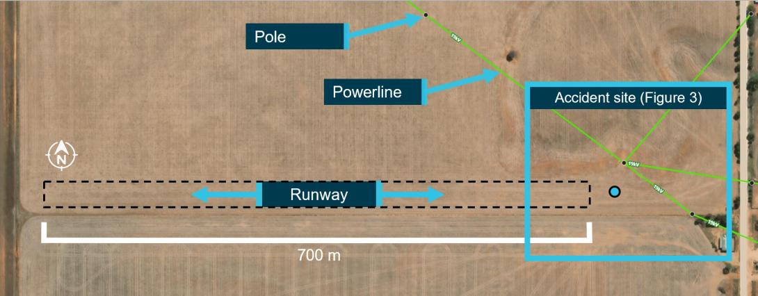
Powerlines are highlighted in green.
Image source: Lookupandlive.com.au, annotated by the ATSB.
The 19 kV powerlines in the vicinity of the eastern threshold of the runway were of the single-wire earth return (SWER) type. The powerline was estimated to be at a height of 8–8.5 m (26–28 ft) at the point of impact.
Civil Aviation Safety Authority (CASA) Advisory Circular AC 91‑02 v1.2 Guidelines for aeroplanes with MTOW not exceeding 5700 kg - suitable places to take off and land (Civil Aviation Safety Authority, 2022) recommends that pilots have a thorough awareness of the obstacles in the approach and climb‑out flight paths. The ATSB estimated that an aircraft heading west with a typical approach angle of 3° would be in conflict with the powerline at any touchdown point less than about 162 m from it. To be at least 15 m (50 ft) clear of the powerline during landing, the touchdown point would need to be at least 453 m from the powerline, leaving about 420 m of runway for the landing roll.
Powerline markers had been fitted to each of the 4 powerlines about 4 m from the pole nearest to the accident site (Figure 3). The markers were marine buoys that had been repurposed as powerline markers. Originally, they would have been bright red, but had faded considerably (Figure 4).
The owner of this infrastructure, SA Power Networks, advised the line markers had been installed in November 2000. They were installed to alert helicopter pilots flying along a powerline for annual pre‑bushfire patrols to the presence of another powerline crossing above or below.
As the runway was not a certified aerodrome or authorised landing area, there was no requirement within the applicable aviation regulations, Australian Standards or elsewhere to mark the powerlines for pilots using the runway.
Figure 3: Accident site and location of powerlines
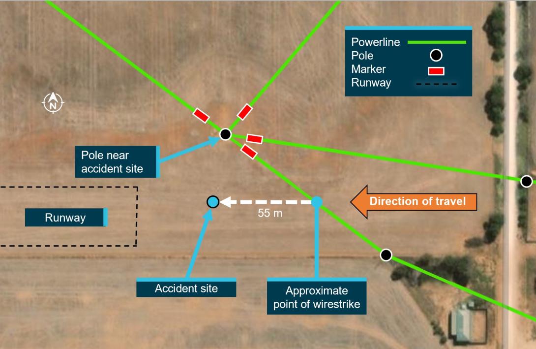
Image source: Lookupandlive.com.au, annotated by the ATSB.
Figure 4: Powerline markers
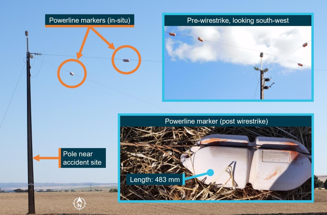
Image source: ATSB, SA Power Networks, annotated by the ATSB.
The pilot was very familiar with the property and the position of the powerlines and had flown from the runway about 4 or 5 times in VH-RSB. In about June 2023, the pilot had previously indicated an intention to use the part of the runway that was opposite to the wires and so was not concerned about the wires.
Recorded data
The pilot intermittently used OzRunways for flight and navigation information. The available data showed a flight in July 2023 from Port Lincoln to a neighbour’s property near the owner’s home (the accident site). In August 2023 the aircraft flew from the same neighbour’s property to Kangaroo Island, South Australia, and returned the following day to the neighbour’s property.
The available data also showed a flight in September 2023 where the aircraft took off and landed 3 times from the owner’s runway (the accident site) and flying in the vicinity (mainly circuits). On these flights, the aircraft always landed heading east. On one occasion it took off to the east, over the powerlines.
There was no OzRunways data for the flight from the neighbour’s property to the owner’s runway, for the accident flight on 8 October 2023, or any other flights.
Wreckage information
The aircraft’s cabin, wings, and fuselage were severely damaged by the intense post‑impact fire, limiting the extent to which pre-impact defects could be identified (Figure 5). However, from the evidence available:
- the wreckage position, damage to the left wing strut, and the marks from the powerline on the propeller, engine cowl, and right wing was consistent with the aircraft striking the oblique powerline heading west
- the aircraft impacted terrain steeply and inverted, probably right wing and engine first
- the propeller had indications that the engine was running at low power at the time of impact
- the flap actuator extension was consistent with a flap setting of 10° (see Cessna 172N flap settings).
Figure 5: VH-RSB at the accident site
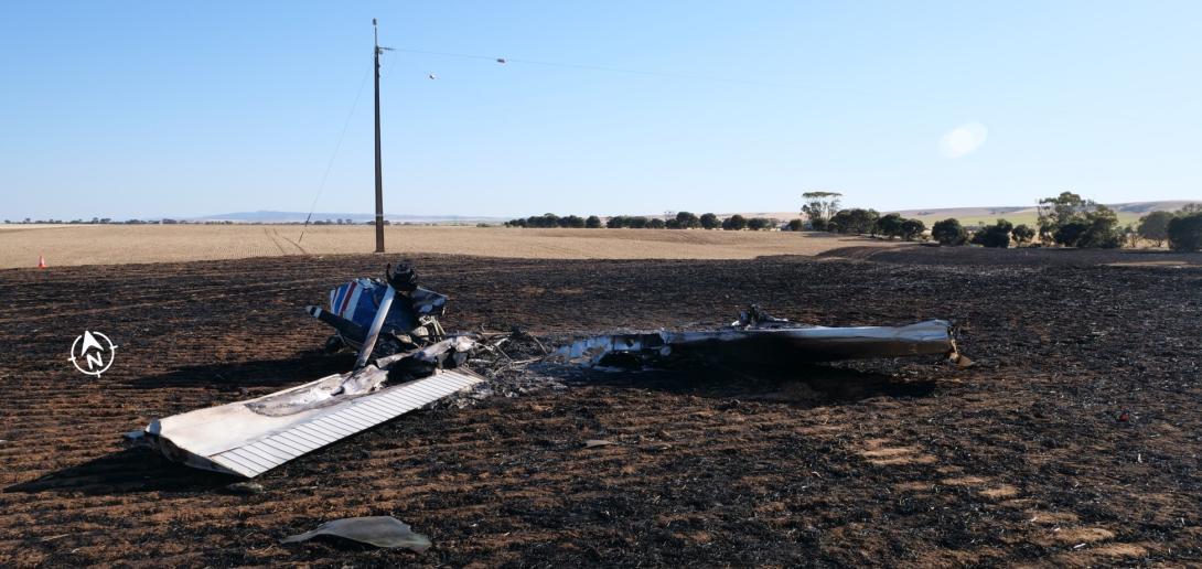
Image source: ATSB.
Survival aspects
When assessing whether an aircraft accident is survivable, a number of aspects are considered, including:
- occupant restraints
- forces imparted on the aircraft occupants
- liveable space inside the aircraft being maintained
- post‑impact fire.
It could not be determined whether the occupants were wearing the aircraft’s upper torso restraints. However, ATSB analysis indicated that the level of deceleration exerted on the occupants of VH-RSB during the collision with terrain was likely to result in serious or fatal injuries. Additionally, the fire significantly reduced the likelihood of the accident being survivable.
Additional information
Cessna 172N flap settings
The Cessna 172N flap system includes a single flap actuator located in the right wing. When a flap setting (0°, 10°, 20°, 30°, or 40°) is selected by the pilot, a jackscrew is driven by an electric motor to that setting.
The normal procedures in the pilot’s operating handbook (POH) for the Cessna 172N state that the flaps should be up (0°) for take‑off, however the approved take‑off range is 0°−10°. For landing, POH states that the flaps can be set as desired and suggests 0°−10° for airspeeds less than 110 kt indicated airspeed (KIAS) and 10°−40° for airspeeds less than 85 KIAS.
Cessna 172N take-off and landing information
Take-off and landing distances for a Cessna 172N vary with a number of factors including the local temperature, wind direction and speed, the elevation of the landing area, and the aircraft’s weight. At sea level, about 290 m can be required for the take-off roll (with additional distance required for obstacle clearance), and the landing roll distance can be around 172 m.
Aerial operations around overhead powerlines
The 2013 ATSB educational publication Avoidable Accidents No. 2: Wirestrikes involving known wires: A manageable aerial agriculture hazard (AR-2011-028) noted that:
…many pilots report that it is almost impossible to see a wire by itself.
Research has shown that it takes between 5.5 and 12.5 seconds for an object to be detected, recognised as a hazard, a decision made on an action, then for that action to be initiated, and the aircraft to respond to that action. Thus, given the inherent difficulty in visually detecting a powerline and the travelling speed of the aircraft, in most cases you will not have enough time to avoid a powerline by the time it can be seen.
The ability of pilots to detect powerlines depends on the physical aspects of the wire, such as the spacing of power poles and the sag of the wire, the orientation of the wire, and the effect of weather (especially visibility). In many cases, the powerline and/or the power pole will blend into the background vegetation or will be obscured by trees etc.
The publication also detailed a number of wirestrikes where aircraft struck a powerline that was known to the pilot. The publication outlines a number of strategies developed by the Aerial Application Association of Australia (AAAA) to help manage the risks associated with aerial operations around overhead powerlines. Regarding aircraft approaching oblique powerlines (as was the case on the accident flight, see Figure 6), the AAAA pilot’s manual states:
Crossing a line of wires at an oblique angle [compared to at a right angle] provides a slower rate of closure with the line as a whole and will allow more time to see it. However, the actual speed of crossing a point directly ahead will of course be the same as if it were crossed at right angles.
The danger here is that the pilot’s preoccupation with this point may lead to a lack of appreciation of the fact that the aircraft’s wing tip will reach the point directly ahead of it slightly earlier. In other words, the pilot may base his [sic] judgement on the wrong section of the wire.
…
A crossing at right angles is to be preferred wherever possible as this reduces the danger area to the thickness of the wire.
Figure 6: Likely approach of VH-RSB to the powerline
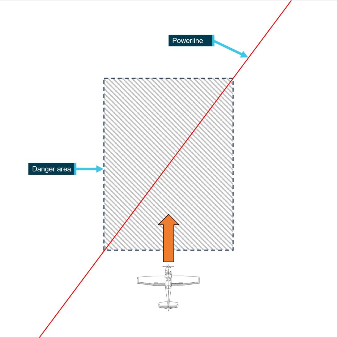
Image source: ATSB, based on a diagram from Aerial Application Association of Australia.
Visual illusions associated with sloping terrain
About 4.5 km to the west of the accident site and runway, the terrain rises up from relatively flat, open farmland to a ridgeline (Figure 7).
As outlined in the US Federal Aviation Administration (FAA) publication AM-400-00/1 – Spatial Disorientation Visual Illusions (Federal Aviation Administration, 2011), runways that are positioned on up- or down‑sloping terrain can produce a visual illusion during the approach to landing. For down‑sloping runways, it can result in the pilot believing their approach is low, pitching up, and inadvertently making a steeper approach. Conversely, for up‑sloping runways, it can result in the pilot believing their approach is high, pitching down, and inadvertently making a shallower approach.
This can be more pronounced if the up‑slope occurs beyond the runway. Pilots may unknowingly move their perception of the horizon toward the top of the rising terrain and create the same visual illusion as an up‑sloping runway, resulting in a shallower approach (Previc and others 2004).
Figure 7: Terrain to the west of the runway
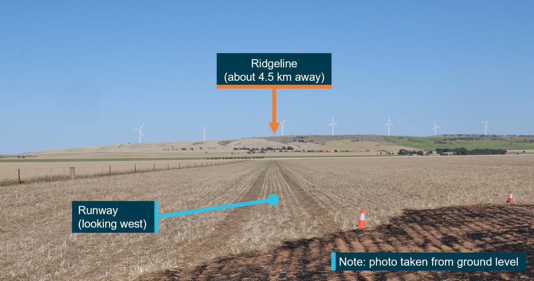
Image source: ATSB.
Safety analysis
Wirestrike
The post‑impact fire limited the extent to which any pre‑impact defects could be identified. However, the available evidence indicates the aircraft was very likely heading west on approach to land when it came into contact with the powerline. Evidence supporting this included:
- the wind direction (as evidenced by the burn direction of the post‑accident fire in the paddock) favoured a landing in that direction
- the indications that the engine was running at a low power setting as would be expected for a final approach to land
- the flaps were extended to a landing setting
- the height of the aircraft when it struck the powerline, which was likely too low for an effective visual inspection of the runway
- the position of the wreckage.
While it could not be established if the pilot had landed on the runway in a westerly direction in the past, the pilot was familiar with the property, the runway and the position of the powerline. Powerlines, especially single wires, are difficult to see from the air, and the pilot likely lost awareness of the powerline and then did not see it when on final approach.
The visual illusions associated with sloping terrain can also occur with up‑sloping terrain in the distance. In this case, the rising terrain beyond the runway could produce this visual illusion. Had this occurred, the pilot may have mistakenly corrected to a shallower approach, putting the aircraft in conflict with the powerline.
Willy-willies were reportedly common in the area and may have been present on the day of the accident. While they can pose a threat to light aircraft and helicopters during low-level operations (such as take‑off and landing), there was no way to determine if a willy-willy was a factor in the accident. In any case, however, the aircraft’s approach path would not have been a sufficient distance from the powerline to assure separation in the event of even a small deviation.
Runway position and powerline marking
The runway was about 700 m long, more than twice the take-off and landing distances required for a Cessna 172N. Moving the runway’s eastern threshold away from the powerline would have reduced the chance of conflict. Even with the existing threshold location, using the end furthest from the powerline for take-off and landing would have reduced the risk of potential conflict.
Recorded data from a day in the month before the accident indicated that the pilot may have intended to reduce the risk of wirestrike when operating from the runway: on that day, 5 of the 6 landings and take-offs used the runway end opposite the wire (and the only exception was a take‑off, which typically provides more clearance over a hazard than a landing the opposite way). However, pilots can forget about hazards, and the thresholds of the runway were not marked, so a pilot could inadvertently revert their aim point for a landing to the east to the start of the runway, putting the aircraft in potential conflict with the powerline.
While there were no powerline markers in line with the runway, the markers adjacent to the nearby pole could alert or remind a pilot to the presence of the powerline. However, their original purpose was to alert pilots flying along a powerline to the presence of another powerline crossing above or below, rather than for a pilot using the runway, and their visibility and location was not optimal for landing on the runway in their locations.
Further, the powerline’s oblique orientation relative to the runway can also increase the chance of a pilot misjudging the point where the aircraft was in conflict, increasing the risk of a wirestrike.
Findings
|
ATSB investigation report findings focus on safety factors (that is, events and conditions that increase risk). Safety factors include ‘contributing factors’ and ‘other factors that increased risk’ (that is, factors that did not meet the definition of a contributing factor for this occurrence but were still considered important to include in the report for the purpose of increasing awareness and enhancing safety). In addition ‘other findings’ may be included to provide important information about topics other than safety factors. These findings should not be read as apportioning blame or liability to any particular organisation or individual. |
From the evidence available, the following findings are made with respect to the wirestrike and collision with terrain involving Cessna 172N, VH-RSB, near Merriton, South Australia on 8 October 2023.
Contributing factors
- The pilot likely lost awareness of and did not see the aerial powerline during approach to land.
- The runway was positioned near an oblique powerline, and the powerline was not marked in a manner sufficient to enhance visibility of the wire to pilots using the runway.
Sources and submissions
Sources of information
The sources of information during the investigation included:
- Aerial Application Association of Australia
- Airservices Australia
- Civil Aviation Safety Authority
- SA Power Networks
- South Australia Police
- maintenance organisation for VH-RSB
- accident witnesses
- recorded data from OzRunways.
References
Aerial Agriculture Association of Australia 2011, Aerial Application Pilots Manual (3rd edition).
Civil Aviation Safety Authority 2022, AC 91‑02 v1.2 – Guidelines for aeroplanes with MTOW not exceeding 5700 kg - suitable places to take off and land.
Federal Aviation Administration AM‑400‑00/1 Spatial Disorientation Visual Illusions, rev. 2/11. Washington DC: U.S. Department of Transportation Federal Aviation Administration.
Previc FH 2004 ‘Visual illusions in flight’, in FH Previc & R Ercoline (Eds) Spatial disorientation in aviation, American Institute of Aeronautics and Astronautics, Reston VA.
Submissions
Under section 26 of the Transport Safety Investigation Act 2003, the ATSB may provide a draft report, on a confidential basis, to any person whom the ATSB considers appropriate. That section allows a person receiving a draft report to make submissions to the ATSB about the draft report.
A draft of this report was provided to the following directly involved parties:
- SA Power Networks
- Civil Aviation Safety Authority.
There were no submissions received.
Purpose of safety investigationsThe objective of a safety investigation is to enhance transport safety. This is done through:
It is not a function of the ATSB to apportion blame or provide a means for determining liability. At the same time, an investigation report must include factual material of sufficient weight to support the analysis and findings. At all times the ATSB endeavours to balance the use of material that could imply adverse comment with the need to properly explain what happened, and why, in a fair and unbiased manner. The ATSB does not investigate for the purpose of taking administrative, regulatory or criminal action. TerminologyAn explanation of terminology used in ATSB investigation reports is available here. This includes terms such as occurrence, contributing factor, other factor that increased risk, and safety issue. Publishing informationReleased in accordance with section 25 of the Transport Safety Investigation Act 2003 Published by: Australian Transport Safety Bureau © Commonwealth of Australia 2024
Ownership of intellectual property rights in this publication Unless otherwise noted, copyright (and any other intellectual property rights, if any) in this report publication is owned by the Commonwealth of Australia. Creative Commons licence With the exception of the Coat of Arms, ATSB logo, and photos and graphics in which a third party holds copyright, this publication is licensed under a Creative Commons Attribution 3.0 Australia licence. Creative Commons Attribution 3.0 Australia Licence is a standard form licence agreement that allows you to copy, distribute, transmit and adapt this publication provided that you attribute the work. The ATSB’s preference is that you attribute this publication (and any material sourced from it) using the following wording: Source: Australian Transport Safety Bureau Copyright in material obtained from other agencies, private individuals or organisations, belongs to those agencies, individuals or organisations. Where you wish to use their material, you will need to contact them directly. |
[1] OzRunways: An electronic flight bag application providing subscriber flight information and navigation service.
[2] Willy-willies (also known as dust devils) are revolving masses of air resulting from local atmospheric instability, such as that caused by intense heating of the air mass adjacent to the ground by the sun on a hot day. They can be 3–100 m in diameter and up to 300 m high. Wind speeds inside the vortex reach a maximum of 100 km/h.


