The Australian Transport Safety Bureau (ATSB) is leading a seabed mapping and underwater search for missing Malaysia Airlines flight 370 in the southern Indian Ocean. Geoscience Australia is providing advice, expertise and support to the ATSB.
There are two planned phases of the search. Phase one, a bathymetric survey providing a detailed map of the seafloor topography of the search area and phase two, a deep ocean search using scanning equipment or submersible vehicles. The information gained in phase one will be used to build a map of the sea floor in the search area, which will aid navigation during phase two.
Multibeam Sonar
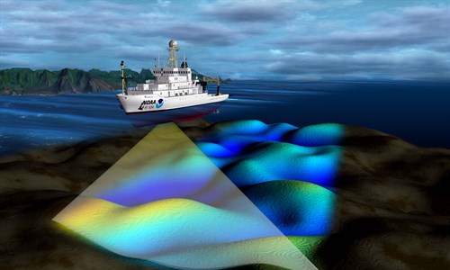
Multibeam sonar is a widely used tool for mapping the sea floor. It measures the amount of time taken for a sound wave to travel between a ship and the sea floor to calculate the depth (bathymetry). Multibeam sonar uses multiple beams to measure a swath of the seabed under the ship, in contrast to single beam sonar which only maps a point below the ship.
In the search area, the water is up to 6000 metres deep, so the survey relies on acquisition of bathymetry using a multibeam system that can detect the sea floor at great depths.
Figure 1:

Source: National Oceanic and Atmospheric Administration, US Dept. of Commerce. (Image is for illustrative purposes only. NOAA vessels are not involved in the search).
To acquire the multibeam data needed for the bathymetric survey, a multibeam sonar is mounted on the hull of the survey vessel. The sonar system sends out a pulse of sound, which reflects off the sea floor and returns to the multibeam sonar device. The time of return provides an indication of how deep the water is.
Water salinity, temperature and depth (pressure) impact on how fast sound travels—and noting that these change throughout a water column, signals are corrected for these changes. Different frequencies are used to map different water depths, with higher frequencies (>100kHz) used for shallow water and low frequencies (<30 kHz) for deeper water.
The survey vessel traverses the area of interest at set distances and the multibeam sonar continuously measures both the water depth and sea floor hardness data concurrently.
More information
Information on multibeam sonar can be found on the Geoscience Australia website.
The MH370: Bathymetric Survey Fact Sheet provides information on bathymetry and its requirement in the search for MH370.
Information about the search for MH370 can be found on:
- the ATSB’s website at www.atsb.gov.au and
the Joint Agency Coordination Centre website at www.jacc.gov.au


